National Register of Historic Places listings in Roberts County, South Dakota

This is a list of the National Register of Historic Places listings in Roberts County, South Dakota.
This is intended to be a complete list of the properties and districts on the National Register of Historic Places in Roberts County, South Dakota, United States. The locations of National Register properties and districts for which the latitude and longitude coordinates are included below, may be seen in a map.[1]
There are 15 properties and districts listed on the National Register in the county.
This National Park Service list is complete through NPS recent listings posted June 7, 2024.[2]
Map all coordinates using OpenStreetMap
Download coordinates as:
- KML
- GPX (all coordinates)
- GPX (primary coordinates)
- GPX (secondary coordinates)
Current listings
| [3] | Name on the Register[4] | Image | Date listed[5] | Location | City or town | Description |
|---|---|---|---|---|---|---|
| 1 | Brown's Post | Upload image | May 27, 1988 (#88000583) | Address Restricted | Sisseton | |
| 2 | Hart School No. 3 |  | August 16, 2000 (#00000994) | Route 1 45°45′14″N 96°53′47″W / 45.7538°N 96.8963°W / 45.7538; -96.8963 (Hart School No. 3) | Sisseton | |
| 3 | Knapp Ranch | 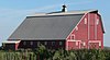 | April 14, 2005 (#05000282) | 13168 450th Avenue 45°28′33″N 97°12′18″W / 45.4758°N 97.2049°W / 45.4758; -97.2049 (Knapp Ranch) | Ortley | |
| 4 | New Effington Hospital |  | July 13, 1989 (#89000829) | Oddin Avenue 45°51′14″N 96°55′05″W / 45.8539°N 96.9181°W / 45.8539; -96.9181 (New Effington Hospital) | New Effington | |
| 5 | New Effington Rest Stop Tipi |  | January 14, 2015 (#14001189) | Mile 250.8 on I-29 45°54′28″N 96°51′51″W / 45.9079°N 96.8642°W / 45.9079; -96.8642 (New Effington Rest Stop Tipi) | New Effington | |
| 6 | Louis Nigg Barn | Upload image | March 1, 2021 (#100006065) | 46356 125th St. 45°34′17″N 97°02′48″W / 45.5713°N 97.0467°W / 45.5713; -97.0467 (Louis Nigg Barn) | Sisseton | |
| 7 | Robar Trading Post | Upload image | May 27, 1988 (#88000582) | Hartford Beach State Park 45°24′09″N 96°39′13″W / 45.4025°N 96.6536°W / 45.4025; -96.6536 (Robar Trading Post) | Wilmot | |
| 8 | Roberts County Courthouse | 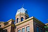 | December 12, 1976 (#76001755) | 411 Second Avenue East[6] 45°39′47″N 97°02′41″W / 45.6631°N 97.0447°W / 45.6631; -97.0447 (Roberts County Courthouse) | Sisseton | |
| 9 | Sisseton Agency Headquarters & Wacipi Grounds | Upload image | February 1, 2022 (#100007395) | 45744 BIA Hwy. 706 45°33′45″N 97°04′17″W / 45.5625°N 97.0713°W / 45.5625; -97.0713 (Sisseton Agency Headquarters & Wacipi Grounds) | Agency Village | |
| 10 | Sisseton Carnegie Library | 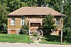 | October 24, 1996 (#96001227) | 215 Oak Street, East 45°39′54″N 97°02′51″W / 45.6649°N 97.0474°W / 45.6649; -97.0474 (Sisseton Carnegie Library) | Sisseton | |
| 11 | Sisseton School | Upload image | November 23, 2020 (#100005818) | 302 East Maple St. 45°39′49″N 97°02′50″W / 45.6637°N 97.0471°W / 45.6637; -97.0471 (Sisseton School) | Sisseton | |
| 12 | Site 39RO71 | Upload image | June 8, 2005 (#05000588) | Address Restricted | Sisseton | Also known as Thunderbird Rock |
| 13 | South Dakota Department of Transportation Bridge No. 55-030-418 |  | December 9, 1999 (#99001437) | State railroad tracks over a local road 45°19′49″N 97°09′55″W / 45.3302°N 97.1652°W / 45.3302; -97.1652 (South Dakota Department of Transportation Bridge No. 55-030-418) | Ortley | |
| 14 | Andrew and Mary Stavig House |  | November 7, 1997 (#97001392) | 112 First Avenue, West 45°39′41″N 97°03′09″W / 45.6615°N 97.0526°W / 45.6615; -97.0526 (Andrew and Mary Stavig House) | Sisseton | |
| 15 | Walla Lutheran Church |  | May 19, 2004 (#04000470) | 46532 105th Street 45°51′56″N 96°53′22″W / 45.8656°N 96.8894°W / 45.8656; -96.8894 (Walla Lutheran Church) | New Effington |
See also
Wikimedia Commons has media related to National Register of Historic Places in Roberts County, South Dakota.
- List of National Historic Landmarks in South Dakota
- National Register of Historic Places listings in South Dakota
References
- ^ The latitude and longitude information provided in this table was derived originally from the National Register Information System, which has been found to be fairly accurate for about 99% of listings. Some locations in this table may have been corrected to current GPS standards.
- ^ National Park Service, United States Department of the Interior, "National Register of Historic Places: Weekly List Actions", retrieved June 7, 2024.
- ^ Numbers represent an alphabetical ordering by significant words. Various colorings, defined here, differentiate National Historic Landmarks and historic districts from other NRHP buildings, structures, sites or objects.
- ^ "National Register Information System". National Register of Historic Places. National Park Service. April 24, 2008.
- ^ The eight-digit number below each date is the number assigned to each location in the National Register Information System database, which can be viewed by clicking the number.
- ^ "Roberts County". South Dakota Unified Judicial System. Retrieved September 15, 2017.
- v
- t
- e

county
- Aurora
- Beadle
- Bennett
- Bon Homme
- Brookings
- Brown
- Brule
- Buffalo
- Butte
- Campbell
- Charles Mix
- Clark
- Clay
- Codington
- Corson
- Custer
- Davison
- Day
- Deuel
- Dewey
- Douglas
- Edmunds
- Fall River
- Faulk
- Grant
- Gregory
- Haakon
- Hamlin
- Hand
- Hanson
- Harding
- Hughes
- Hutchinson
- Hyde
- Jackson
- Jerauld
- Jones
- Kingsbury
- Lake
- Lawrence
- Lincoln
- Lyman
- Marshall
- McCook
- McPherson
- Meade
- Mellette
- Miner
- Minnehaha
- Moody
- Oglala Lakota
- Pennington
- Perkins
- Potter
- Roberts
- Sanborn
- Spink
- Stanley
- Sully
- Todd
- Tripp
- Turner
- Union
- Walworth
- Yankton
- Ziebach
 Category
 List
List National Register of Historic Places Portal


Municipalities and communities of Roberts County, South Dakota, United States | ||
|---|---|---|
County seat: Sisseton | ||
| Cities |  | |
| Towns | ||
| CDPs | ||
| Other communities | ||
| Townships | ||
| Indian reservation | ||
| Footnotes | ‡This populated place also has portions in an adjacent county or counties | |
| ||


