Mare Acidalium quadrangle
Map of Mars
47°30′N 30°00′W / 47.5°N 30°W / 47.5; -30 
The Mare Acidalium quadrangle is one of a series of 30 quadrangle maps of Mars used by the United States Geological Survey (USGS) Astrogeology Research Program. The quadrangle is located in the northeastern portion of Mars' western hemisphere and covers 300° to 360° east longitude (0° to 60° west longitude) and 30° to 65° north latitude. The quadrangle uses a Lambert conformal conic projection at a nominal scale of 1:5,000,000 (1:5M). The Mare Acidalium quadrangle is also referred to as MC-4 (Mars Chart-4).[1]
The southern and northern borders of the quadrangle are approximately 3,065 km and 1,500 km wide, respectively. The north to south distance is about 2,050 km (slightly less than the length of Greenland).[2] The quadrangle covers an approximate area of 4.9 million square km, or a little over 3% of Mars' surface area.[3] Most of the region called Acidalia Planitia is found in Acidalium quadrangle. Parts of Tempe Terra, Arabia Terra, and Chryse Planitia are also in this quadrangle.
This area contains many bright spots on a dark background that may be mud volcanoes. There are also some gullies that are believed to have formed by relatively recent flows of liquid water.[4]
Origin of name
Mare Acidalium (Acidalian Sea) is the name of a telescopic albedo feature located at 45° N and 330° E on Mars. The feature was named for a well or fountain in Boeotia, Greece. According to classical tradition, it is a location where Venus and the Graces bathed.[5] The name was approved by the International Astronomical Union (IAU) in 1958.[6]
Physiography and geology
The quadrangle contains many interesting features, including gullies and possible shorelines of an ancient northern ocean. Some areas are densely layered. The boundary between the southern highlands and the northern lowlands lies in Mare Acidalium.[7] The "Face on Mars", of great interest to the general public, is located near 40.8 degrees north and 9.6 degrees west, in an area called Cydonia. When Mars Global Surveyor examined it with high resolution, the face turned out to just be an eroded mesa.[8] Mare Acidalium contains the Kasei Valles system of canyons. This huge system is 300 miles wide in some places—Earth's Grand Canyon is only 18 miles wide.[9]
Gullies
The HiRISE image below of Acidalia Colles shows gullies in the northern hemisphere. Gullies occur on steep slopes, especially craters. Gullies are believed to be relatively young because they have few, if any craters, and they lie on top of sand dunes which are themselves young. Usually, each gully has an alcove, channel, and apron. Although many ideas have been put forward to explain them, the most popular involve liquid water either coming from an aquifer or left over from old glaciers.[4]
-
 Gullies on crater wall The bright apron is a bit unusual.
 -
 Gully on crater wall The bright apron is a bit unusual.


-
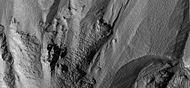
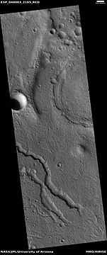
 Acidalia Colles Gullies and other features, as seen by HiRISE. The scale bar is 1,000 meters long.
 -
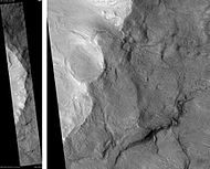
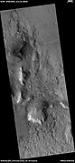
 Context for next image of Bamberg crater. Box shows where the next image came from. This is a CTX image from Mars Reconnaissance Orbiter.
 -
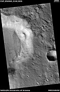
 Gullies and massive flow of material, as seen by HiRISE under HiWish program. Gullies are enlarged in next two images. Location is Bamberg crater.
 -
 Close up view of some gullies, as seen by HiRISE under the HiWish program
 -
 Close up view of another gully in same HiRISE picture. Picture taken under HiWish program.
 -
 Gullies, as seen by HiRISE under HiWish program
 -
 Gullies in a crater, as seen by HiRISE under HiWish program
 -
 Close-up of gullies in a crater from previous image. Image taken by HiRISE under HiWish program.
 -
 Gullies on wall of crater, as seen by HiRISE under HiWish program. Location is the Mare Acidalium quadrangle.
 -
 Close-up of gully channels, as seen by HiRISE under HiWish program. This image shows many streamlined forms and some benches along a channel. These features suggest formation by running water. Benches are usually formed when the water level goes down a bit and stays at that level for a time. Picture was taken with HiRISE under HiWish program. Location is the Mare Acidalium quadrangle. Note this is an enlargement of a previous image.
 -
 Gullies, as seen by HiRISE under HiWish program
 -
 Gullies, as seen by HiRISE under HiWish program


There is evidence for both theories. Most of the gully alcove heads occur at the same level, just as one would expect of an aquifer. Various measurements and calculations show that liquid water could exist in an aquifer at the usual depths where the gullies begin.[10] One variation of this model is that rising hot magma could have melted ice in the ground and caused water to flow in aquifers. Aquifers are layers that allow water to flow. They may consist of porous sandstone. This layer would be perched on top of another layer that prevents water from going down (in geological terms it would be called impermeable). The only direction the trapped water can flow is horizontally. The water could then flow out onto the surface when the aquifer reaches a break, like a crater wall. Aquifers are quite common on Earth. A good example is "Weeping Rock" in Zion National Park Utah.[11]
On the other hand, there is evidence for the alternative theory because much of the surface of Mars is covered by a thick smooth mantle that is thought to be a mixture of ice and dust. This ice-rich mantle, a few yards thick, smooths the land, but in places it has a bumpy texture, resembling the surface of a basketball. Under certain conditions the ice could melt and flow down the slopes to create gullies. Since there are few craters on this mantle, the mantle is relatively young. An excellent view of this mantle is in the picture of the Ptolemaeus Crater Rim, as seen by HiRISE.
Changes in Mars' orbit and tilt cause significant changes in the distribution of water ice from polar regions down to latitudes equivalent to Texas. During certain climate periods water vapor leaves polar ice and enters the atmosphere. The water comes back to ground at lower latitudes as deposits of frost or snow mixed generously with dust. The atmosphere of Mars contains a great deal of fine dust particles. Water vapor condenses on the particles, then the heavier particles with the water coating fall and pile up on the ground. When ice at the top of the mantling layer goes back into the atmosphere, it leaves behind dust, which insulates the remaining ice.[12]
Polygonal patterned ground
Polygonal, patterned ground is quite common in some regions of Mars.[13][14][15][16][17][18][19] It is commonly believed to be caused by the sublimation of ice from the ground. Sublimation is the direct change of solid ice to a gas. This is similar to what happens to dry ice on the Earth. Places on Mars that display polygonal ground may indicate where future colonists can find water ice. Patterned ground forms in a mantle layer, called latitude dependent mantle, that fell from the sky when the climate was different.[20][21][22][23]
- Close-up of gullies in a crater showing plygons that have been called "gullygons" Image taken by HiRISE under HiWish program.
-
 Close-up of gully alcove showing "gullygons" (polygonal patterned ground near gullies), as seen by HiRISE under HiWish program Note this is an enlargement of a previous image.
 -
 Close-up of gully alcove showing "gullygons" (polygonal patterned ground near gullies), as seen by HiRISE under HiWish program Note this is an enlargement of a previous image.


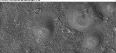
Craters
Impact craters generally have a rim with ejecta around them, in contrast volcanic craters usually do not have a rim or ejecta deposits.[24] Sometimes craters display layers. Since the collision that produces a crater is like a powerful explosion, rocks from deep underground are tossed unto the surface. Hence, craters can show us what lies deep under the surface.
-
 Kunowsky Crater Floor, as seen by HiRISE. The scale bar is 500 meters long.
 -
 Bonestell Crater, as seen by HiRISE. Scale bar is 1000 meters long.
 -
 Arandas Crater, as seen by HiRISE. Click on image for a better view of North and South Walls, as well as central hills. Scale bar is 1000 meters long.
 -
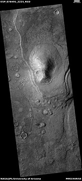
 Exhumed Crater in Mare Acidalium, as seen by Mars Global Surveyor
 -
 Group of craters that may have struck the surface at the same time after an asteroid broke up. If the craters were formed at different times, they would have wiped away parts of the others. Picture was taken by HiRISE, under HiWish program. Image located in Terra Cimmeria.
 -
 Crater with ejecta, as seen by HiRISE under HiWish program. The box shows area enlarged in next image.
 -
 Enlarged view of crater ejecta showing channel with a deposit at the end, as seen by HiRISE under HiWish program
 -
 Close-up of surface near ejecta of crater, as seen by HiRISE under HiWish program. Melted ice from ground water may have formed small channel.
 -
 Crater wall covered with a smooth mantle, as seen by HiRISE under HiWish program
 -
 Crater with pits on floor, as seen by HiRISE under HiWish program


Mud volcanoes
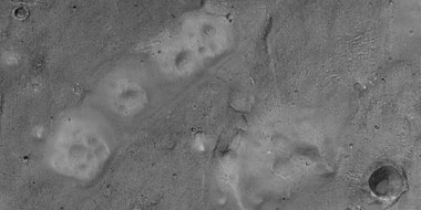
Large areas of Mare Acidalium display bright spots on a dark background. It has been suggested that the spots are mud volcanoes.[25][26][27] More than 18,000 of these features, which have an average diameter of about 800 meters, have been mapped.[28] Mare Acidalium would have received large quantities of mud and fluids form outflow channels, so much mud may have accumulated there. The bright mounds have been found to contain crystalline ferric oxides. Mud volcanism here may be highly significant because long lived conduits for upwelling groundwater could have been produced. These could have been habitats for micro organisms.[29] Mud volcanoes could have brought up samples from deep zones that could therefore be sampled by robots.[30] An article in Icarus reports on a study of these possible mud volcanoes. The authors compare these Martian features to mud volcanoes found on the Earth. There study using HiRISE images and CRISM data support the idea that these features are indeed mud volcanoes. Nanophase ferric minerals and hydrated minerals found with Compact Reconnaissance Imaging Spectrometer for Mars (CRISM) show that water was involved with the formation of these possible Martian mud volcanoes.[31]
-
 Craters with white centers in Mare Acidalium. Sand dunes are visible in low areas in image. Some of the features may be mud volcanoes. Picture taken by Mars Global Surveyor under the MOC Public Targeting Program.
 -
 Mud volcanoes near the edge of the ejecta of a nearby crater, as seen by HiRISE under the HiWish program
 -
 Large field of cones that may be mud volcanoes, as seen by HiRISE under HiWish program
 -
 Close-up of possible mud volcanoes, as seen by HiRISE under HiWish program. Note: this is an enlargement of the previous image.
 -
 Possible mud volcano, as seen by HiRISE under HiWish program
 -
 Line of possible mud volcanoes, as seen by HiRISE under HiWish program
 -
 Mud volcanoes, as seen by HiRISE under HiWish program


-
 Wide view of field of mud volcanoes, as seen by HiRISE under HiWish program
 -
 Close view of mud volcanoes, as seen by HiRISE under HiWish program
 -
 Close view of mud volcanoes and boulders, as seen by HiRISE under HiWish program
 -
 Close view of boulders near mud volcanoes, as seen by HiRISE under HiWish program. The boulders may be from an upper layer. Mud from a mud volcano does not contain boulders, only fine-grain material.
 -
 Wide view of mud volcanoes, as seen by HiRISE under HiWish program
 -
 Close view of mud volcanoes, as seen by HiRISE
 -
 Close view of mud volcanoes, as seen by HiRISE. Low area around the volcanoes contains transverse aeolian ridges (TAR's). Only part of picture is in color because HiRISE only takes a color strip in middle of image.


-
 Close view of mud volcanoes on Earth. Location is Gobustan, Azerbaijan.

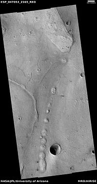
Channels in Idaeus Fossae region
There is a 300 km long river system in Idaeus Fossae. It is carved into the highlands of Idaeus Fossae, and it originated from the melting of ice in the ground after asteroid impacts. Dating has determined that the water activity came after most of the water activity ended at the boundary between the Noachian and Hesperian periods. Lakes and fan-shaped deposits were formed by running water in this system as it drained eastward into Liberta Crater and formed a delta deposit. Part of the drainage path is the Moa Valley.[32][33]
-
 Stream meander and cutoff, as seen by HiRISE under HiWish program. This is part of a major drainage system in the Idaeus Fossae region.
 -
 Hanging valley, as seen by HiRISE under HiWish program. This may have been a waterfall at one time.
 -
 Hanging valley that once may have been a waterfall, as seen by HiRISE under HiWish program


Channels
There is enormous evidence that water once flowed in river valleys on Mars.[34][35] Images of curved channels have been seen in images from Mars spacecraft dating back to the early 1970s with the Mariner 9 orbiter.[36][37][38][39] Indeed, a study published in June 2017, calculated that the volume of water needed to carve all the channels on Mars was even larger than the proposed ocean that the planet may have had. Water was probably recycled many times from the ocean to rainfall around Mars.[40][41]
-
 Sklodowska (Martian crater), as seen by CTX camera (on Mars Reconnaissance Orbiter). Small channels are visible along the eroded, southern rim.
 -
 Channels in Sklodowska Crater, as seen by CTX camera (on Mars Reconnaissance Orbiter). Note: this is an enlargement of the previous image.
 -
 Channels in Sklodowska Crater, as seen by HiRISE under the HiWish program
 -
 Channels, as seen by HiRISE under HiWish program
 -
 Channels, as seen by HiRISE under HiWish program
 -
 Channels, as seen by HiRISE under HiWish program
 -
 Channel network, as seen by HiRISE under HiWish program
 -
 Meandering stream showing early and later loops
 -
 Meander. Cutoff was formed, which made a shortcut for the water.


Ocean
Many researchers have suggested that Mars once had a great ocean in the north.[42][43][44][45][46][47][48] Much evidence for this ocean has been gathered over several decades. New evidence was published in May 2016. A large team of scientists described how some of the surface in Ismenius Lacus quadrangle was altered by two Tsunamis. The tsunamis were caused by asteroids striking the ocean. Both were thought to have been strong enough to create 30 km diameter craters. The first tsunami picked up and carried boulders the size of cars or small houses. The backwash from the wave formed channels by rearranging the boulders. The second came in when the ocean was 300 m lower. The second carried a great deal of ice which was dropped in valleys. Calculations show that the average height of the waves would have been 50 m, but the heights would vary from 10 m to 120 m. Numerical simulations show that in this particular part of the ocean two impact craters of the size of 30 km in diameter would form every 30 million years. The implication here is that a great northern ocean may have existed for millions of years. One argument against an ocean has been the lack of shoreline features. These features may have been washed away by these tsunami events. The parts of Mars studied in this research are Chryse Planitia and northwestern Arabia Terra. These tsunamis affected some surfaces in the Ismenius Lacus quadrangle and in the Mare Acidalium quadrangle.[49][50][51][52]
Pingos
Pingos are believed to be present on Mars. They are mounds that contain cracks. These particular fractures were evidently produced by something emerging from below the brittle surface of Mars. Ice lenses, resulting from the accumulation of ice beneath the surface, possibly created these mounds with fractures. Ice is less dense than rock, so the buried ice rose and pushed upwards on the surface and generated these cracks. An analogous process creates similar sized mounds in arctic tundra on Earth that are known as pingos, an Inuit word.[53] They contain pure water ice, so they would be a great source of water for future colonists on Mars.
-
 Arrows point to possible pingos, as seen by HiRISE under HiWish program. Pingos contain a core of pure ice.

Fractured ground
-
 Fractures, as seen by HiRISE under HiWish program. These fractures are believed to eventually turn into canyons because ice in the ground will disappear into the thin Martian atmosphere and the remaining dust will be blown away.
 -
 Wide view of fractured ground, as seen by HiRISE under HiWish program. Cracks form on the Martian surface, and then they turn into large fractures.
 -
 Close view of fractures from the previous image, as seen by HiRISE under HiWish program
 -
 Cracks on crater floor, as seen by HiRISE under HiWish program
 -
 Close view of cracks on crater floor, as seen by HiRISE under HiWish program
 -
 Group of cracks, as seen by HiRISE under HiWish program
 -
 Close view of cracks of various sizes, as seen by HiRISE under HiWish program. Ice disappears along crack surfaces and makes crack larger. Note that small craters do not have very big rims; they may be just pits.
 -
 Close view of cracks of various sizes, as seen by HiRISE under HiWish program. Ice disappears along crack surfaces and makes crack larger.
 -
 Cracks around crater, as seen by HiRISE under HiWish program


Layers
Rock can be formed into layers in a variety of ways. Volcanoes, wind, or water can produce layers.[54] Layers can be hardened by the action of groundwater. Martian ground water probably moved hundreds of kilometers, and in the process it dissolved many minerals from the rock it passed through. When ground water surfaces in low areas containing sediments, water evaporates in the thin atmosphere and leaves behind minerals as deposits and/or cementing agents. Consequently, layers of dust could not later easily erode away since they were cemented together.
,
-
 Layers in mesa, as seen by HiRISE under HiWish program
 -
 Close view of layers in mesa, as seen by HiRISE under HiWish program
 -
 Layers and small craters, as seen by HiRISE under HiWish program. Layers are enlarged in next image.
 -
 Layers, as seen by HiRISE under HiWish program
 -
 Close view of layers in a trough, as seen by HiRISE under HiWish program
 -
 Layered mesa, as seen by HiRISE under HiWish program


Other landscape features
-
 Cliff in Kasei Valles system, as seen by HiRISE
 -
 Enlargement of cliff in Kasei Valles system in previous image showing boulders and their tracks, as seen by HiRISE. Click on image to see a boulder only 2.2 yards across (smaller than a bedroom).
 -
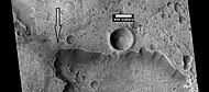
 CTX image showing the context for the next image of a fault
 -
 Close-up of a possible fault in Mare Acidalium, as seen by HiRISE under the HiWish program. A circle is drawn around crater to show that it may be off round because of movement of the fault. Many other faults are in the region.
 -
 Fan with channels on its surface, as seen by HiRISE under HiWish program
 -
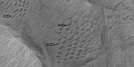 Sample of oval pits in this location of unknown origin, as seen by HiRISE under HiWish program
 -
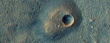
 Crater with very small rim, as seen by HiRISE under HiWish program
 -
 Field of small pits, as seen by HiRISE under HiWish program
 -
 Fan This fan is formed on the edge of a crater. Dirt and rocks mixed with water, flowed down a slope and were deposited in crater. The fan has layers which means that this was done at different intervals, not all at once.


Other Mars quadrangles

0°N 180°W / 0°N 180°W / 0; -180
0°N 0°W / 0°N -0°E / 0; -0
90°N 0°W / 90°N -0°E / 90; -0
MC-04
Mare Acidalium
()
- view
- talk
Interactive Mars map

(See also: Mars Rovers map and Mars Memorial map) (view • discuss)
See also
References
- ^ Davies, M.E.; Batson, R.M.; Wu, S.S.C. "Geodesy and Cartography" in Kieffer, H.H.; Jakosky, B.M.; Snyder, C.W.; Matthews, M.S., Eds. Mars. University of Arizona Press: Tucson, 1992.
- ^ Distances calculated using NASA World Wind measuring tool. http://worldwind.arc.nasa.gov/.
- ^ Approximated by integrating latitudinal strips with area of R^2 (L1-L2)(cos(A)dA) from 30° to 65° latitude; where R = 3889 km, A is latitude, and angles expressed in radians. See: https://stackoverflow.com/questions/1340223/calculating-area-enclosed-by-arbitrary-polygon-on-earths-surface.
- ^ a b Heldmann, J.; Mellon, M. (2004). "Observations of martian gullies and constraints on potential formation mechanisms. 2004". Icarus. 168 (2): 285–304. Bibcode:2004Icar..168..285H. doi:10.1016/j.icarus.2003.11.024.
- ^ Blunck, J. 1982. Mars and its Satellites. Exposition Press. Smithtown, N.Y.
- ^ USGS Gazetteer of Planetary Nomenclature. Mars. http://planetarynames.wr.usgs.gov/.
- ^ "HiRISE | A Complex Crater in Arabia Terra (PSP_010354_2165)".
- ^ "Mars Global Surveyor MOC2-283 Release".
- ^ "HiRISE | (Almost) Silent Rolling Stones in Kasei Valles". Archived from the original on 2016-10-01. Retrieved 2009-02-19.
- ^ Heldmann, J.; Mellon, M. (2004). "Observations of martian gullies and constraints on potential formation mechanisms". Icarus. 168 (2): 285–304. Bibcode:2004Icar..168..285H. doi:10.1016/j.icarus.2003.11.024.
- ^ Harris, A and E. Tuttle. 1990. Geology of National Parks. Kendall/Hunt Publishing Company. Dubuque, Iowa
- ^ MLA NASA/Jet Propulsion Laboratory (2003, December 18). Mars May Be Emerging From An Ice Age. ScienceDaily. Retrieved February 19, 2009, from https://www.sciencedaily.com/releases/2003/12/031218075443.htmAds by GoogleAdvertise
- ^ "Refubium - Search" (PDF).
- ^ Kostama, V.-P.; Kreslavsky, Head (2006). "Recent high-latitude icy mantle in the northern plains of Mars: Characteristics and ages of emplacement". Geophys. Res. Lett. 33 (11): L11201. Bibcode:2006GeoRL..3311201K. doi:10.1029/2006GL025946. S2CID 17229252.
- ^ Malin, M.; Edgett, K. (2001). "Mars Global Surveyor Mars Orbiter Camera: Interplanetary cruise through primary mission". J. Geophys. Res. 106 (E10): 23429–23540. Bibcode:2001JGR...10623429M. doi:10.1029/2000je001455.
- ^ Milliken, R.; et al. (2003). "Viscous flow features on the surface of Mars: Observations from high-resolution Mars Orbiter Camera (MOC) images". J. Geophys. Res. 108 (E6): 5057. Bibcode:2003JGRE..108.5057M. doi:10.1029/2002JE002005.
- ^ Mangold, N (2005). "High latitude patterned grounds on Mars: Classification, distribution and climatic control". Icarus. 174 (2): 336–359. Bibcode:2005Icar..174..336M. doi:10.1016/j.icarus.2004.07.030.
- ^ Kreslavsky, M., Head, J. 2000. Kilometer-scale roughness on Mars: Results from MOLA data analysis. J. Geophys. Res. 105 (E11), 26695–26712.
- ^ Seibert, N.; Kargel, J. (2001). "Small-scale martian polygonal terrain: Implications for liquid surface water". Geophys. Res. Lett. 28 (5): 899–902. Bibcode:2001GeoRL..28..899S. doi:10.1029/2000gl012093.
- ^ Hecht, M (2002). "Metastability of water on Mars". Icarus. 156 (2): 373–386. Bibcode:2002Icar..156..373H. doi:10.1006/icar.2001.6794.
- ^ Mustard, J.; et al. (2001). "Evidence for recent climate change on Mars from the identification of youthful near-surface ground ice". Nature. 412 (6845): 411–414. Bibcode:2001Natur.412..411M. doi:10.1038/35086515. PMID 11473309. S2CID 4409161.
- ^ Kreslavsky, M.A., Head, J.W., 2002. High-latitude Recent Surface Mantle on Mars: New Results from MOLA and MOC. European Geophysical Society XXVII, Nice.
- ^ Head, J.W.; Mustard, J.F.; Kreslavsky, M.A.; Milliken, R.E.; Marchant, D.R. (2003). "Recent ice ages on Mars". Nature. 426 (6968): 797–802. Bibcode:2003Natur.426..797H. doi:10.1038/nature02114. PMID 14685228. S2CID 2355534.
- ^ Hugh H. Kieffer (1992). Mars. University of Arizona Press. ISBN 978-0-8165-1257-7. Retrieved 7 March 2011.
- ^ Farrand, W.; et al. (2005). "Pitted cones and domes on Mars: observations in Acidalia Planitia and Cydonia Mensae using MOC, THEMIS, and TES data". J. Geophys. Res. 110 (E5): 14. Bibcode:2005JGRE..110.5005F. doi:10.1029/2004JE002297.
- ^ Tanaka, K.; et al. (2003). "Resurfacing history of the northern plains of Mars based on geologic mapping of Mars Global Surveyor data". J. Geophys. Res. 108 (E4): 8043. Bibcode:2003JGRE..108.8043T. doi:10.1029/2002JE001908.
- ^ Grotzinger, J. and R. Milliken (eds.) 2012. Sedimentary Geology of Mars. SEPM
- ^ Oehler, D. and C. Allen. 2010. Evidence for pervasive mud volcanism in Acidalia Planitia, Mars. Icarus: 208. 636-657.
- ^ Komatsu, G., et al. 2014. ASTROBIOLOGICAL POTENTIAL OF MUD VOLCANISM ON MARS. 45th Lunar and Planetary Science Conference (2014). 1085.pdf
- ^ Oehler, D; Allen, C. (2011). "Evidence for pervasive mud volcanism in Acidalia Planitia, Mars". Icarus. 208 (2): 636–657. Bibcode:2010Icar..208..636O. doi:10.1016/j.icarus.2010.03.031.
- ^ Komatsu, G., et al. 2016. Small edifice features in Chryse Planitia, Mars: Assessment of a mud volcano hypothesis. Icarus: 268, 56-75.
- ^ Salese, F.; Di Achille, F.; et al. (2016). "Hydrological and sedimentary analyses of well-preserved paleo fluvial- paleolacustrine systems at Moa Valles, Mars". J. Geophys. Res. Planets. 121 (2): 194–232. Bibcode:2016JGRE..121..194S. doi:10.1002/2015JE004891. S2CID 130651090.
- ^ Salese, F., G. Di Achille, G. Ori. 2015. SEDIMENTOLOGY OF A RIVER SYSTEM WITH A SERIES OF DAM-BREACH PALEOLAKES AT IDAEUS FOSSAE, MARS. 46th Lunar and Planetary Science Conference 2296.pdf
- ^ Baker, V.; et al. (2015). "Fluvial geomorphology on Earth-like planetary surfaces: a review". Geomorphology. 245: 149–182. doi:10.1016/j.geomorph.2015.05.002. PMC 5701759. PMID 29176917.
- ^ Carr, M. 1996. in Water on Mars. Oxford Univ. Press.
- ^ Baker, V. 1982. The Channels of Mars. Univ. of Tex. Press, Austin, TX
- ^ Baker, V.; Strom, R.; Gulick, V.; Kargel, J.; Komatsu, G.; Kale, V. (1991). "Ancient oceans, ice sheets and the hydrological cycle on Mars". Nature. 352 (6336): 589–594. Bibcode:1991Natur.352..589B. doi:10.1038/352589a0. S2CID 4321529.
- ^ Carr, M (1979). "Formation of Martian flood features by release of water from confined aquifers". J. Geophys. Res. 84: 2995–300. Bibcode:1979JGR....84.2995C. doi:10.1029/jb084ib06p02995.
- ^ Komar, P (1979). "Comparisons of the hydraulics of water flows in Martian outflow channels with flows of similar scale on Earth". Icarus. 37 (1): 156–181. Bibcode:1979Icar...37..156K. doi:10.1016/0019-1035(79)90123-4.
- ^ "How Much Water Was Needed to Carve Valleys on Mars? - SpaceRef". 5 June 2017.
- ^ Luo, W.; et al. (2017). "New Martian valley network volume estimate consistent with ancient ocean and warm and wet climate". Nature Communications. 8: 15766. Bibcode:2017NatCo...815766L. doi:10.1038/ncomms15766. PMC 5465386. PMID 28580943.
- ^ Parker, Timothy J.; Gorsline, Donn S.; Saunders, R. Stephen; Pieri, David C.; Schneeberger, Dale M. (1993). "Coastal geomorphology of the Martian northern plains". Journal of Geophysical Research. 98 (E6): 11061. Bibcode:1993JGR....9811061P. doi:10.1029/93je00618.
- ^ Fairén, Alberto G.; Dohm, James M.; Baker, Victor R.; De Pablo, Miguel A.; Ruiz, Javier; Ferris, Justin C.; Anderson, Robert C. (2003). "Episodic flood inundations of the northern plains of Mars" (PDF). Icarus. 165 (1): 53–67. Bibcode:2003Icar..165...53F. doi:10.1016/s0019-1035(03)00144-1.
- ^ Head Iii, J. W. (1999). "Possible Ancient Oceans on Mars: Evidence from Mars Orbiter Laser Altimeter Data". Science. 286 (5447): 2134–2137. Bibcode:1999Sci...286.2134H. doi:10.1126/science.286.5447.2134. PMID 10591640.
- ^ Parker, Timothy J.; Stephen Saunders, R.; Schneeberger, Dale M. (1989). "Transitional morphology in West Deuteronilus Mensae, Mars: Implications for modification of the lowland/upland boundary". Icarus. 82 (1): 111–145. Bibcode:1989Icar...82..111P. doi:10.1016/0019-1035(89)90027-4.
- ^ Carr, Michael H. (2003). "Oceans on Mars: An assessment of the observational evidence and possible fate". Journal of Geophysical Research. 108 (E5): 5042. Bibcode:2003JGRE..108.5042C. doi:10.1029/2002JE001963.
- ^ Kreslavsky, Mikhail A.; Head, James W. (2002). "Fate of outflow channel effluents in the northern lowlands of Mars: The Vastitas Borealis Formation as a sublimation residue from frozen ponded bodies of water". Journal of Geophysical Research: Planets. 107 (E12): 4–1–4–25. Bibcode:2002JGRE..107.5121K. doi:10.1029/2001JE001831.
- ^ Clifford, S. (2001). "The Evolution of the Martian Hydrosphere: Implications for the Fate of a Primordial Ocean and the Current State of the Northern Plains". Icarus. 154 (1): 40–79. Bibcode:2001Icar..154...40C. doi:10.1006/icar.2001.6671.
- ^ "Ancient Tsunami Evidence on Mars Reveals Life Potential" (Press release). May 20, 2016.
- ^ Rodriguez, J. Alexis P.; Fairén, Alberto G.; Tanaka, Kenneth L.; Zarroca, Mario; Linares, Rogelio; Platz, Thomas; Komatsu, Goro; Miyamoto, Hideaki; Kargel, Jeffrey S.; Yan, Jianguo; Gulick, Virginia; Higuchi, Kana; Baker, Victor R.; Glines, Natalie (2016). "Tsunami waves extensively resurfaced the shorelines of an early Martian ocean". Scientific Reports. 6: 25106. Bibcode:2016NatSR...625106R. doi:10.1038/srep25106. PMC 4872529. PMID 27196957.
- ^ Rodriguez, J. Alexis P.; Fairén, Alberto G.; Tanaka, Kenneth L.; Zarroca, Mario; Linares, Rogelio; Platz, Thomas; Komatsu, Goro; Miyamoto, Hideaki; Kargel, Jeffrey S.; Yan, Jianguo; Gulick, Virginia; Higuchi, Kana; Baker, Victor R.; Glines, Natalie (2016). "Tsunami waves extensively resurfaced the shorelines of an early Martian ocean". Scientific Reports. 6: 25106. Bibcode:2016NatSR...625106R. doi:10.1038/srep25106. PMC 4872529. PMID 27196957.
- ^ "Ancient tsunami evidence on Mars reveals life potential". May 19, 2016.
- ^ "HiRISE | Spider Webs (ESP_046359_1250)".
- ^ "Home". hirise.lpl.arizona.edu?PSP_008437_1750.
- ^ Morton, Oliver (2002). Mapping Mars: Science, Imagination, and the Birth of a World. New York: Picador USA. p. 98. ISBN 0-312-24551-3.
- ^ "Online Atlas of Mars". Ralphaeschliman.com. Retrieved December 16, 2012.
- ^ "PIA03467: The MGS MOC Wide Angle Map of Mars". Photojournal. NASA / Jet Propulsion Laboratory. February 16, 2002. Retrieved December 16, 2012.
Wikimedia Commons has media related to Mare Acidalium quadrangle.


Portal:
 Solar System

| Authority control databases: National |
|
|---|


