HiWish program
NASA program for public suggestions for MRO images
HiWish is a program created by NASA so that anyone can suggest a place for the HiRISE camera on the Mars Reconnaissance Orbiter to photograph.[1][2][3] It was started in January 2010. In the first few months of the program 3000 people signed up to use HiRISE.[4][5] The first images were released in April 2010.[6] Over 12,000 suggestions were made by the public; suggestions were made for targets in each of the 30 quadrangles of Mars. Selected images released were used for three talks at the 16th Annual International Mars Society Convention. Below are some of the over 4,224 images that have been released from the HiWish program as of March 2016.[7]
Glacial features
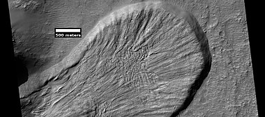
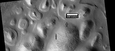
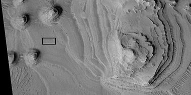
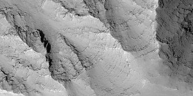
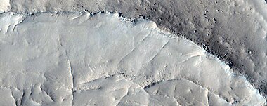
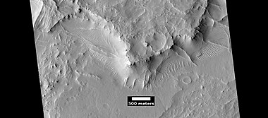
Some landscapes look just like glaciers moving out of mountain valleys on Earth. Some have a hollowed-out appearance, looking like a glacier after almost all the ice has disappeared. What is left are the moraines—the dirt and debris carried by the glacier. The center is hollowed out because the ice is mostly gone.[8] These supposed alpine glaciers have been called glacier-like forms (GLF) or glacier-like flows (GLF).[9] Glacier-like forms are a later and maybe more accurate term because we cannot be sure the structure is currently moving.[10]

-
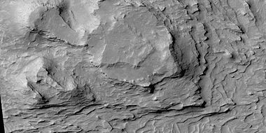
 Possible glacier flowing down a valley and spreading out on a plain. Rectangle shows a portion that is enlarged in the next image.
 -
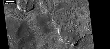
 Enlargement of the area in the rectangle in the previous image. This area would be called a moraine in an alpine glacier on Earth.
 -
 Well-developed hollows of concentric crater fill, as seen by HiRISE under the HiWish program
 -
 Glacier on a crater floor, as seen by HiRISE under HiWish program. The cracks in the glacier may be crevasses. There is also a gully system on the crater wall.
 -
 Glacier coming out of valley, as seen by HiRISE under HiWish program. Location is rim of Moreux Crater. Location is Ismenius Lacus quadrangle.


-
 Wide view of tongue-shaped flows, as seen by HiRISE under the HiWish program
 -
 Close view of tongue-shaped flows, as seen by HiRISE under the HiWish program


Possible pingos
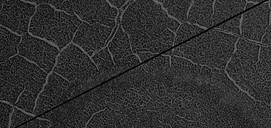
The radial and concentric cracks visible here are common when forces penetrate a brittle layer, such as a rock thrown through a glass window. These particular fractures were probably created by something emerging from below the brittle Martian surface. Ice may have accumulated under the surface in a lens shape; thus making these cracked mounds. Ice being less dense than rock, pushed upwards on the surface and generated these spider web-like patterns. A similar process creates similar sized mounds in arctic tundra on Earth. Such features are called "pingos", an Inuit word.[11] Pingos would contain pure water ice; thus they could be sources of water for future colonists of Mars. Many features that look like the pingos on the Earth are found in Utopia Planitia (~35-50° N; ~80-115° E).[12]
-
 Possible pingos with scale, as seen by HiRISE under HiWish program
 -
 Close view of possible pingo with scale, as seen by HiRISE under HiWish program


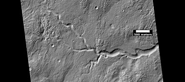
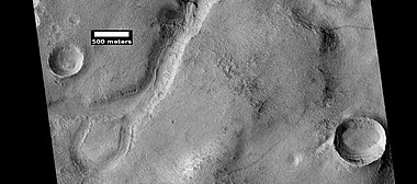
Ancient rivers and streams
There is great deal of evidence that water once flowed in river valleys on Mars. Pictures from orbit show winding valleys, branched valleys, and even meanders with oxbow lakes.[13] Some are visible in the pictures below.
-
 Channel on floor of Newton Crater, as seen by HiRISE under HiWish program
 -
 Branched channel, as seen by HiRISE under HiWish program
 -
 Channel, as seen by HiRISE under HiWish program
 -
 Branched channel, as seen by HiRISE under HiWish program
 -
 Oxbow lake, as seen by HiRISE under HiWish program
 -
 Valleys as seen by HiRISE under HiWish program
 -
 Channel in Arabia, as seen by HiRISE under HiWish program
 -
 Channel system that travels through part of a crater, as seen by HiRISE under HiWish program
 -
 Channels, as seen by HiRISE under HiWish program. Stream appears to have eroded through a hill.
 -
 Channel showing an old oxbow and a cutoff, as seen by HiRISE under HiWish program. Location is Memnonia quadrangle.
 -
 Channel on floor of valley, as seen by HiRISE under HiWish program. Location is Eridania quadrangle.
 -
 Close view of channel in Ismenius Lacus quadrangle, as seen by HiRISE under HiWish program
 -
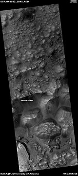
 Channel with hanging valley in Ismenius Lacus quadrangle, as seen by HiRISE under HiWish program
 -
 Hanging valleys in Aram Chaos, as seen by HiRISE under HiWish program
 -
 Wide view of channels in Ismenius Lacus quadrangle, as seen by HiRISE under HiWish program


Streamlined shapes
Streamlined shapes represent more evidence of past flowing water on Mars. Water shaped features into streamlined shapes.
-
 Streamlined feature, as seen by HiRISE under HiWish program. Location is Memnonia quadrangle.
 -
 Channel, as seen by HiRISE under HiWish program. Streamlined shapes are indicated with arrows. Location is the Phaethontis quadrangle.


-
 Wide view of streamlined shapes in Amenthes quadrangle, as seen by HiRISE under HiWish program
 -
 Close view of streamlined shapes, as seen by HiRISE under HiWish program. Arrow indicates the direction of past flowing water.
 -
 Close view of streamlined shapes, as seen by HiRISE under HiWish program
 -
 Close view of streamlined shapes, as seen by HiRISE under HiWish program
 -
 Close view of streamlined shapes, as seen by HiRISE under HiWish program
 -
 Close view of streamlined shape, as seen by HiRISE under HiWish program
 -
 Streamlined shapes, as seen by HiRISE under HiWish program. Location is the Elysium quadrangle.


New crater
-
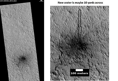 HiRISE images showing discovery of a new crater with HiWish program
 -
 New crater, as seen by HiRISE under HiWish program. The new crater indicated with the white arrow is about 10 yards across and was probably created by the collision with an object the size of a large watermelon. This crater did not appear in earlier images of the same region.


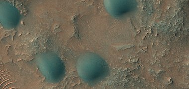
Sand dunes
Many locations on Mars have sand dunes. The dunes are covered by a seasonal carbon dioxide frost that forms in early autumn and remains until late spring. Many martian dunes strongly resemble terrestrial dunes but images acquired by the High-Resolution Imaging Science Experiment on the Mars Reconnaissance Orbiter have shown that martian dunes in the north polar region are subject to modification via grainflow triggered by seasonal CO2 sublimation, a process not seen on Earth. Many dunes are black because they are derived from the dark volcanic rock basalt. Extraterrestrial sand seas such as those found on Mars are referred to as "undae" from the Latin for waves.
-
 Dunes in two craters, as seen by HiRISE under the HiWish program
 -
 Dunes among craters, as seen by HiRISE under HiWish program. Some of these are barchans.
 -
 Dunes on a crater floor, as seen by HiRISE under HiWish program. Most of these are barchans. Box shows location of next image. Location is the Eridania quadrangle.
 -
 Dunes on a crater floor, as seen by HiRISE under HiWish program. Most of these are barchans. Note: this is an enlargement of the center of the previous image.
 -
 Dunes, as seen by HiRISE under HiWish program. Location is Eridania quadrangle.
 -
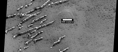 Defrosting dunes and ice in troughs of polygons, as seen by HiRISE under HiWish program
 -
 Color view of defrosting dunes and ice in troughs of polygons, as seen by HiRISE under HiWish program
 -
 Defrosting surface, as seen by HiRISE under HiWish program. Frost is disappearing in patches from a dune. The trough boundaries around the polygon shapes still contain frost; hence they are white. Note: the north side (side near top) has not defrosted because the sun is coming from the other side.
 -
 Wide view of dunes in Moreux Crater, as seen by HiRISE under HiWish program
 -
 Dunes in Mare Tyrrhenum quadrangle, as seen by HiRISE under HiWish program
 -
 Close view of dunes in Mare Tyrrhenum quadrangle, as seen by HiRISE under HiWish program
 -
 Close, color view of dunes in Mare Tyrrhenum quadrangle, as seen by HiRISE under HiWish program. Ripples are visible on dune surface.
 -
 Close, color view of dome sand dunes, as seen by HiRISE under HiWish program


Landing site
Some of the targets suggested became possible sites for a Rover Mission in 2020. The targets were in Firsoff (crater) and Holden Crater. These locations were picked as two of 26 locations considered for a mission that will look for signs of life and gather samples for a later return to Earth.[14][15][16]
-
 Layers in Firsoff Crater, as seen by HiRISE under HiWish program. Note: this image field can be found in the previous image of the layers in Firsoff Crater, as seen by CTX camera (on Mars Reconnaissance Orbiter).
 -
 Close-up of layers in Firsoff Crater, as seen by HiRISE. Note: this is an enlargement of the previous image of Firsoff Crater.
 -
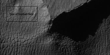
 Layers in Firsoff crater with a box showing the size of a football field. Picture taken by HiRISE under HiWish program.
 -
 Layers and faults in Firsoff Crater, as seen by HiRISE under HiWish program. Arrows show one large fault, but there are other smaller ones in the picture.
 -
![Part of delta in Holden Crater, as seen by HiRISE under HiWish program. Holden crater is a possible landing site for a Mars Rover scheduled for 2020.[17]](//upload.wikimedia.org/wikipedia/commons/thumb/e/e9/ESP_026126_1530delta.jpg/160px-ESP_026126_1530delta.jpg) Part of delta in Holden Crater, as seen by HiRISE under HiWish program. Holden crater is a possible landing site for a Mars Rover scheduled for 2020.[17]
Part of delta in Holden Crater, as seen by HiRISE under HiWish program. Holden crater is a possible landing site for a Mars Rover scheduled for 2020.[17] -
 Close view of previous image showing layers, as seen by HiRISE under HiWish program and enlarged with HiView


![Part of delta in Holden Crater, as seen by HiRISE under HiWish program. Holden crater is a possible landing site for a Mars Rover scheduled for 2020.[17]](http://upload.wikimedia.org/wikipedia/commons/thumb/e/e9/ESP_026126_1530delta.jpg/160px-ESP_026126_1530delta.jpg)

Landscape features
-
 Troughs to the East of Albor Tholus, as seen by HiRISE under the HiWish program
 -
 Portion of a trough (Fossae) in Elysium Planitia, as seen by HiRISE under the HiWish program. Blue indicates possible seasonal frost.
 -
 Landslide in a crater, as seen by HiRISE under HiWish program. Image from Iapygia quadrangle.
 -
 Wide view of Buttes and Mesas, as seen by HiRISE under HiWish program. Location is Elysium quadrangle.
 -
 Buttes and mesas, as seen by HiRISE under HiWish program. Note: this is an enlargement of the previous image.
 -
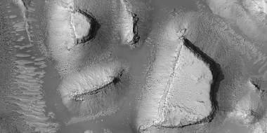 Mesas, as seen by HiRISE under HiWish program. Note: this is an enlargement of a previous image.


Dark slope streaks
-
 Layers and dark slope streaks, as seen by HiRISE under HiWish program
 -
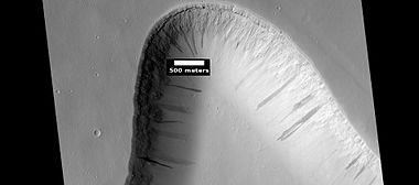
 Dark slope streaks on mesa, as seen by HiRISE under HiWish program. Location is Amazonis quadrangle.
 -
 Close-up of some layers under cap rock of a pedestal crater and a dark slope streak, as seen by HiRISE under HiWish program
 -
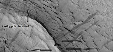 Dark slope streaks and layers near a pedestal crater, as seen by HiRISE under the HiWish program. Arrows show the small starting points for the streaks.
 -
 Dark slope streaks on mound in Lycus Sulci in Diacria quadrangle, as seen by HiRISE under HiWish program
 -
 Layers in trough and dark slope streaks, as seen by HiRISE under HiWish program. Location is Amazonis quadrangle.


Recurrent slope lineae
Recurrent slope lineae are small dark streaks on slopes that elongate in warm seasons. They may be evidence of liquid water.[18][19][20] However, there remains debate about whether water or much water is needed.[21][22][23]
-
 Wide view of part of Valles Marineris, as seen by HiRISE under HiWish program. Box shows location of recurrent slope lineae that are enlarged in next image.
 -
![Close, color view of recurrent slope lineae, as seen by HiRISE under HiWish program. Arrows point to some of the recurrent slope lineae [24]](//upload.wikimedia.org/wikipedia/commons/thumb/9/94/49955_1665rslcolorarrows.jpg/380px-49955_1665rslcolorarrows.jpg) Close, color view of recurrent slope lineae, as seen by HiRISE under HiWish program. Arrows point to some of the recurrent slope lineae [24]
Close, color view of recurrent slope lineae, as seen by HiRISE under HiWish program. Arrows point to some of the recurrent slope lineae [24]

![Close, color view of recurrent slope lineae, as seen by HiRISE under HiWish program. Arrows point to some of the recurrent slope lineae [24]](http://upload.wikimedia.org/wikipedia/commons/thumb/9/94/49955_1665rslcolorarrows.jpg/380px-49955_1665rslcolorarrows.jpg)
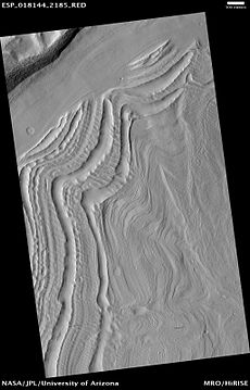
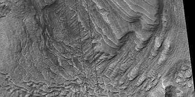
Layers
Many places on Mars show rocks arranged in layers. Rock can form layers in a variety of ways. Volcanoes, wind, or water can produce layers.[25] Layers can be hardened by the action of groundwater.
-
 Layers exposed at the base of a group of buttes in Mangala Valles in Memnonia quadrangle, as seen by HiRISE under HiWish program. Arrows point to boulders sitting in pits. The pits may have formed by winds, heat from the boulders melting ground ice, or some other process.
 -
 Buttes, as seen by HiRISE under HiWish program. Buttes have layered rocks with a hard resistant cap rock on the top which protects the underlying rocks from erosion.
 -
 Butte in Crommelin Crater, as seen by HiRISE under HiWish program. Location is Oxia Palus quadrangle.
 -
 Layers in Crommelin Crater, as seen by HiRISE under HiWish program. Location is Oxia Palus quadrangle.


-
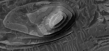
 Layered mound on floor of Danielson Crater, as seen by HiRISE under HiWish program
 -
 Close, color view of layers and dark dust on floor of Danielson Crater, as seen by HiRISE under HiWish program
 -
 Close, color view of layers and dark dust on floor of Danielson Crater, as seen by HiRISE under HiWish program. Boulders are visible in the image.
 -
 Close, color view of layers and dark dust on floor of Danielson Crater, as seen by HiRISE under HiWish program. Faults are indicated with arrows.
 -
 Close view of layers on floor of Danielson Crater, as seen by HiRISE under HiWish program. Some faults are visible in image.


-
 Light toned butte on floor of crater, as seen by HiRISE under HiWish program. Arrows show outcrops of light toned material. Light toned material is probably sulfate-rich and similar to material examined by Spirit Rover, and it once probably covered the whole floor. Other images below show enlargements of the butte. Location is Margaritifer Sinus quadrangle.
 -
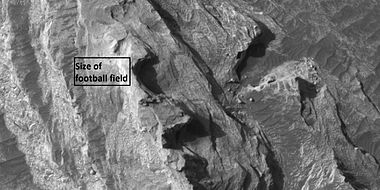
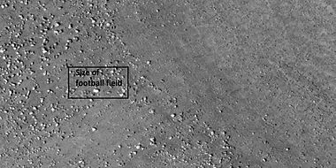
 Enlargement of white butte, as seen by HiRISE under HiWish program. Box shows size of a football field.
 -
 Closer view towards top of white butte, as seen by HiRISE under HiWish program. Box shows size of a football field.
 -
 Top of white butte, as seen by HiRISE under HiWish program. Box shows size of a football field.


-
 Layered terrain in Aeolis quadrangle, as seen by HiRISE under HiWish program.
 -
 Wide view of layered terrain, as seen by HiRISE under HiWish program. Location is northeast of Gale Crater in Aeolis quadrangle.
 -
 Close view of mound with layers, as seen by HiRISE under HiWish program. Note: this is an enlargement from the previous image.
 -
 Close view of mound with layers, as seen by HiRISE under HiWish program. Note: this is an enlargement from a previous image.
 -
 Layers in Arabia, as seen by HiRISE under HiWish program.
 -
 Wide view of part of Danielson Crater, as seen by HiRISE under HiWish program
 -
 Enlargement of previous image of Danielson Crater, as seen by HiRISE under HiWish program. The box represents the size of a football field.
 -
 Close-up of layers in Danielson Crater, as seen by HiRISE under HiWish program—boulders are visible, as well as dark sand
 -
 Close-up of layers in trough south of Ius Chasma, as seen by HiRISE under HiWish program
 -
 Close-up of layers in Lotto Crater, as seen by HiRISE under HiWish program
 -
 Layers, as seen by HiRISE under HiWish program. Location is Tempe Terra.
 -
 Layers, as seen by HiRISE under HiWish program. Location is Tempe Terra Note: this is an enlargement of the previous image.


-
 Close view of layers, as seen by HiRISE under HiWish program. At least one layer is light-toned which may indicated hydrated minerals.
 -
 Close view of layers, as seen by HiRISE under HiWish program


This group of layers that are found in a crater all come from the Arabia quadrangle.
-
 Wide view of layers in crater, as seen by HiRISE under HiWish program. Parts of this image are enlarged in other images that follow.
 -
 Close view of layers, as seen by HiRISE under HiWish program. Box shows the size of a football field.
 -
 Close view of layers, as seen by HiRISE under HiWish program. Box shows the size of a football field.
 -
 Close view of layers, as seen by HiRISE under HiWish program. Box shows the size of a football field.
 -
 Close view of layers, as seen by HiRISE under HiWish program
 -
 Close view of layers, as seen by HiRISE under HiWish program
 -
 Close view of layers, as seen by HiRISE under HiWish program
 -
 Close view of layers, as seen by HiRISE under HiWish program
 -
 Close view of layers, as seen by HiRISE under HiWish program


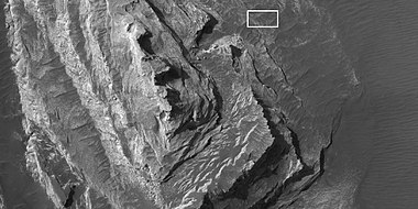
This next group of layered terrain comes from the Louros Valles in the Coprates quadrangle.
-
 Wide view of layers in Louros Valles, as seen by HiRISE under HiWish program
 -
 Close view of layers in Louros Valles, as seen by HiRISE under HiWish program. Note this is an enlargement of a previous image.
 -
 Close view of layers in Louros Valles, as seen by HiRISE under HiWish program. Note this is an enlargement of a previous image.
 -
 Close view of layers in Louros Valles, as seen by HiRISE under HiWish program. Note this is an enlargement of a previous image.
 -
 Close view of layers in Louros Valles, as seen by HiRISE under HiWish program. Note this is an enlargement of a previous image.


Layers in ice cap
-
 Layers in northern ice cap with an angular unconformity, as seen by HiRISE under HiWish program
 -
 Close view of layers in northern ice cap, as seen by HiRISE under HiWish program. Arrows point to an angular unconformity.
 -
 Close, color view of layers in northern ice cap, as seen by HiRISE under HiWish program
 -
 Layers exposed in northern ice cap, as seen by HiRISE under HiWish program
 -
 Close view of layers exposed in northern ice cap, as seen by HiRISE under HiWish program


Gullies
Martian gullies are small, incised networks of narrow channels and their associated downslope sediment deposits, found on the planet of Mars. They are named for their resemblance to terrestrial gullies. First discovered on images from Mars Global Surveyor, they occur on steep slopes, especially on the walls of craters. Usually, each gully has a dendritic alcove at its head, a fan-shaped apron at its base, and a single thread of incised channel linking the two, giving the whole gully an hourglass shape.[26] They are believed to be relatively young because they have few, if any craters. On the basis of their form, aspects, positions, and location amongst and apparent interaction with features thought to be rich in water ice, many researchers believed that the processes carving the gullies involve liquid water. However, this remains a topic of active research.

-
 Close-up of gully aprons showing they are free of craters; hence very young. Location is Phaethontis quadrangle. Picture was taken by HiRISE under HiWish program.
 -
 Gullies on wall of crater, as seen by HiRISE under HiWish program. Location is the Mare Acidalium quadrangle.
 -
 Close-up of gully channels, as seen by HiRISE under HiWish program. This image shows many streamlined forms and some benches along a channel. These features suggest formation by running water. Benches are usually formed when the water level goes down a bit and stays at that level for a time. Picture was taken with HiRISE under HiWish program. Location is the Mare Acidalium quadrangle. Note this is an enlargement of a previous image.
 -
 Gullies in crater in Phaethontis quadrangle, as seen by HiRISE under HiWish program
 -
 Gullies along mesa wall in North Tempe Terra, as seen by HiRISE under HiWish program
 -
 Close view of gully apron, as seen by HiRISE under HiWish program. Note this is an enlargement of the previous image.
 -
 Close view of gully alcove, as seen by HiRISE under HiWish program. Note this is an enlargement of a previous image.


-
 Gullies in crater, as seen by HiRISE under HiWish program
 -
 Close view of gullies from previous image The channels are quite curved. Because channels of gullies often form curves, it was thought that they were made by flowing water. Today, it is thought that they could be produced with chunks of dry ice. The image is from HiRISE under HiWish program.


Latitude dependent mantle
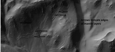
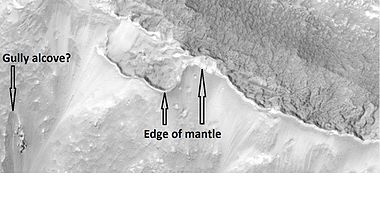
Much of the Martian surface is covered with a thick ice-rich, mantle layer that has fallen from the sky a number of times in the past.[27][28][29] In some places a number of layers are visible in the mantle.[30]
-
 Surface showing appearance with and without mantle covering, as seen by HiRISE, under the HiWish program. Location is Terra Sirenum in Phaethontis quadrangle.
 -
 Mantle layers, as seen by HiRISE under HiWish program. Location is Eridania quadrangle
 -
 Close up view of mantle, as seen by HiRISE under the HiWish program. Mantle may be composed of ice and dust that fell from the sky during past climatic conditions. Location is Cebrenia quadrangle.
 -
 Close view of mantle, as seen by HiRISE under HiWish program. Arrows show craters along edge which highlight the thickness of mantle. Location is Ismenius Lacus quadrangle.
 -
 Close view that displays the thickness of the mantle, as seen by HiRISE under HiWish program. Location is Ismenius Lacus quadrangle.


-
 Wide view of surface with spots displaying mantle, as seen by HiRISE under HiWish program. Location is the Arcadia quadrangle.
 -
 Close view of mantle, as seen by HiRISE under HiWish program
 -
 Close view of mantle, as seen by HiRISE under HiWish program


It fell as snow and ice-coated dust. There is good evidence that this mantle is ice-rich. The shapes of the polygons common on many surfaces suggest ice-rich soil. High levels of hydrogen (probably from water) have been found with Mars Odyssey.[31][32][33][34][35] Thermal measurements from orbit suggest ice.[36][37] The Phoenix (spacecraft) discovered water ice with made direct observations since it landed in a field of polygons.[38][39] In fact, its landing rockets exposed pure ice. Theory had predicted that ice would be found under a few cm of soil. This mantle layer is called "latitude dependent mantle" because its occurrence is related to the latitude. It is this mantle that cracks and then forms polygonal ground. This cracking of ice-rich ground is predicted based on physical processes.[40][41][42][43][44][45][46]
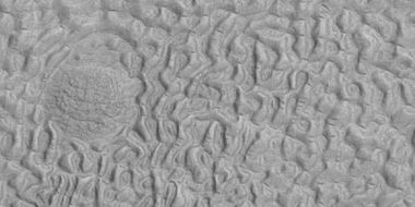
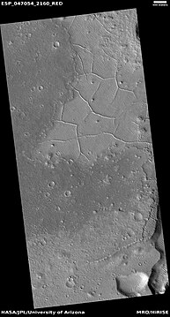
Polygonal patterned ground
Polygonal, patterned ground is quite common in some regions of Mars.[47][48][49][50][45][51][52] It is commonly believed to be caused by the sublimation of ice from the ground. Sublimation is the direct change of solid ice to a gas. This is similar to what happens to dry ice on the Earth. Places on Mars that display polygonal ground may indicate where future colonists can find water ice. Patterned ground forms in a mantle layer, called latitude dependent mantle, that fell from the sky when the climate was different.[27][28][53][54]
-
 Wide view of crater containing polygons with frost in the low parts, as seen by HiRISE under the HiWish program
 -
 Closer view of polygons with frost in the low parts, as seen by HiRISE under the HiWish program
 -
 Still closer view of polygons, as seen by HiRISE under the HiWish program
 -
 Close view of polygons with frost in the low parts, as seen by HiRISE under the HiWish program. Circular shapes are also visible.


-
 High center polygons, shown with arrows, as seen by HiRISE under HiWish program. Location is Casius quadrangle. Image enlarged with HiView.
 -
 Scalloped terrain labeled with both low center polygons and high center polygons, as seen by HiRISE under HiWish program. Location is Casius quadrangle. Image enlarged with HiView.
 -
 High and low center polygons, as seen by HiRISE under HiWish program. Location is Casius quadrangle. Image enlarged with HiView.
 -
 Close-up of high center polygons seen by HiRISE under HiWish program. Troughs between polygons are easily visible in this view. Location is Ismenius Lacus quadrangle.
 -
 Low center polygons, as seen by HiRISE under HiWish program. Location is Casius quadrangle. Image enlarged with HiView. Location is Casius quadrangle.
 -
 Close view of snout of glacier, as seen by HiRISE under the HiWish program. High center polygons are visible. Box shows size of football field.
 -
 Close view of high center polygons near glacier, as seen by HiRISE under the HiWish program. Box shows size of football field.
 -
 Close view of high center polygons near glacier, as seen by HiRISE under the HiWish program


-
 Wide view of a group of channels, as seen by HiRISE under HiWish project Some parts of the surface show patterned ground when enlarged.
 -
 Patterned ground, as seen by HiRISE under HiWish program. This is a close up from previous image.
 -
 Ridges, as seen by HiRISE under HiWish program. This is a close up from a previous image.
 -
 Color view of surface in a previous image, as seen by HiRISE under HiWish program
 -
 Color image of patterned ground, enlarged from a previous image, as seen by HiRISE under HiWish program


Complex polygonal patterned ground
-
 Wide view of polygons, as seen by HiRISE under HiWish program. Parts of this image are enlarged in following images. The location is the Noachis quadrangle.
 -
 Polygons, as seen by HiRISE under HiWish program
 -
 Close view of polygons, as seen by HiRISE under HiWish program. Arrow point to boulders that sit inside of small craters.
 -
 Close view of polygons, as seen by HiRISE under HiWish program
 -
 Close view of polygons, as seen by HiRISE under HiWish program


Exposed ice sheets
HiRISE images taken under the HiWish program found triangular shaped depressions in Milankovic Crater that researchers found contain vast amounts of ice that are found under only 1–2 meters of soil. These depressions contain water ice in the straight wall that faces the pole, according to the study published in the journal Science. Eight sites were found with Milankovic Crater being the only one in the northern hemisphere. Research was conducted with instruments on board the Mars Reconnaissance Orbiter (MRO).[55][56][57][58][59]
The following images are ones referred to in this study of subsurface ice sheets.[60]
-
 Wide view of part of Milankovic Crater, as seen by HiRISE under HiWish program. Many depressions here contain ice in their walls.
 -
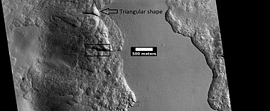 Close view from a previous image, as seen by HiRISE under HiWish program. The triangular shape of some depressions are noted. The area in the box is enlarged in following images.
 -
 Close view of depression, as seen by HiRISE under HiWish program. Arrows indicate where there is a very thin, 1–2 meter covering on what is believed to be ice.


These triangular depressions are similar to those in scalloped terrain. However scalloped terrain, displays a gentle equator-facing slope and is rounded. Scarps discussed here have a steep pole-facing side and have been found between 55 and 59 degrees north and south latitude[60] Scalloped topography is common in the mid-latitudes of Mars, between 45° and 60° north and south.
Scalloped topography
Scalloped topography is common in the mid-latitudes of Mars, between 45° and 60° north and south. It is particularly prominent in the region of Utopia Planitia[61][62] in the northern hemisphere and in the region of Peneus and Amphitrites Patera[63][64] in the southern hemisphere. Such topography consists of shallow, rimless depressions with scalloped edges, commonly referred to as "scalloped depressions" or simply "scallops". Scalloped depressions can be isolated or clustered and sometimes seem to coalesce. A typical scalloped depression displays a gentle equator-facing slope and a steeper pole-facing scarp. This topographic asymmetry is probably due to differences in insolation. Scalloped depressions are believed to form from the removal of subsurface material, possibly interstitial ice, by sublimation. This process may still be happening at present.[65]
On November 22, 2016, NASA reported finding a large amount of underground ice in the Utopia Planitia region of Mars.[66] The volume of water detected has been estimated to be equivalent to the volume of water in Lake Superior.[67][68] The volume of water ice in the region were based on measurements from the ground-penetrating radar instrument on Mars Reconnaissance Orbiter, called SHARAD. From the data obtained from SHARAD, "dielectric permittivity", or the dielectric constant was determined. The dielectric constant value was consistent with a large concentration of water ice.[69][70][71]
-
 Scalloped ground, as seen by HiRISE under HiWish program
 -
 Close-up of scalloped ground, as seen by HiRISE under HiWish program. Surface is divided into polygons; these forms are common where ground freezes and thaws. Note: this is an enlargement of a previous image.
 -
 Scalloped ground, as seen by HiRISE under HiWish program
 -
 Close-up of scalloped ground, as seen by HiRISE under HiWish program. Surface is divided into polygons; these forms are common where ground freezes and thaws. Note: this is an enlargement of a previous image.
 -
 Low center polygons, shown with arrows, as seen by HiRISE under HiWish program. Image was enlarged with HiView.
 -
 Scalloped terrain, as seen by HiRISE under HiWish program. The location is the Casius quadrangle.
 -
 Scalloped terrain, as seen by HiRISE under HiWish program. The location is the Casius quadrangle.


Pedestal craters
A pedestal crater is a crater with its ejecta sitting above the surrounding terrain and thereby forming a raised platform (like a pedestal). They form when an impact crater ejects material which forms an erosion-resistant layer, thus causing the immediate area to erode more slowly than the rest of the region. Some pedestals have been accurately measured to be hundreds of meters above the surrounding area. This means that hundreds of meters of material were eroded away. The result is that both the crater and its ejecta blanket stand above the surroundings. Pedestal craters were first observed during the Mariner missions.[72][73][74][75]
-
 Pedestal crater, as seen by HiRISE under HiWish program. Top layer has protected the lower material from being eroded. The location is Casius quadrangle.
 -
 Pedestal crater, as seen by HiRISE under HiWish program. Location is Hellas quadrangle.
 -
 Pedestal crater, as seen by HiRISE under HiWish program. Location is Casius quadrangle.
 -
 Pedestal crater, as seen by HiRISE under HiWish program. Location is Cebrenia quadrangle.


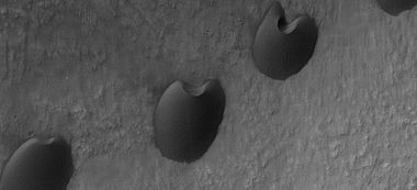
Ring mold craters
Ring mold craters are believed to be formed from asteroid impacts into ground that has an underlying layer of ice. The impact produces an rebound of the ice layer to form a "ring-mold" shape.
Another, later idea, for their formation suggests that the impacting body goes through layers of different densities. Later, erosion could have helped shape them. It was thought that ring-mold craters could only exist in areas with large amounts of ground ice. However, with more extensive analysis of larger areas, it was found the ring mold craters are sometimes formed where there is not as much ice underground.[76] [77]
-
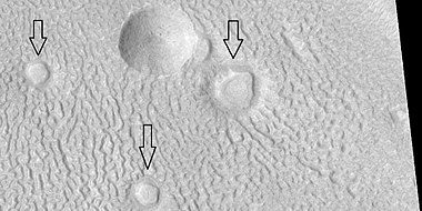
 Ring mold craters of various sizes on floor of a crater, as seen by HiRISE under HiWish program. Location is Ismenius Lacus quadrangle.
 -
 Wide view of a field of ring mold craters, as seen by HiRISE under HiWish program
 -
 Close view of ring mold crater, as seen by HiRISE under HiWish program. Note: this is an enlargement of the previous image of a field of ring mold craters.


-
 Wide view of ring-mold craters on floor of larger crater, as seen by HiRISE under HiWish program
 -
 Ring-mold craters, as seen by HiRISE under HiWish program
 -
 Close view of ring-mold craters and brain terrain, as seen by HiRISE under HiWish program


Halo craters
-
![Pedestal crater with boulders along rim. Such craters are called "halo craters".[78] Picture taken with HiRISE under HiWish program.](//upload.wikimedia.org/wikipedia/commons/thumb/7/78/ESP_044939_2390pedestalhalocrater.jpg/380px-ESP_044939_2390pedestalhalocrater.jpg) Pedestal crater with boulders along rim. Such craters are called "halo craters".[78] Picture taken with HiRISE under HiWish program.
Pedestal crater with boulders along rim. Such craters are called "halo craters".[78] Picture taken with HiRISE under HiWish program. -
 Close view of boulders on lower left of crater rim Box is the size of a football field, so boulders are roughly the size of cars or small houses. Picture taken with HiRISE under HiWish program.
 -
 Close view of boulders along crater rim Boulders are roughly the size of cars or small houses. Picture taken with HiRISE under HiWish program.
![Pedestal crater with boulders along rim. Such craters are called "halo craters".[78] Picture taken with HiRISE under HiWish program.](http://upload.wikimedia.org/wikipedia/commons/thumb/7/78/ESP_044939_2390pedestalhalocrater.jpg/380px-ESP_044939_2390pedestalhalocrater.jpg)


Boulders
-
 Boulders, as seen by HiRISE under HiWish program. Location is Ismenius Lacus quadrangle.
 -
 Boulder and boulder tracks, as seen by HiRISE under HiWish program. The arrow shows a boulder that has made a track in the sand as it rolled down dune. Location is Mare Boreum quadrangle.
 -
 Boulders and tracks, as seen by HiRISE under HiWish program. The arrows show a boulders that have produced a track by rolling down dune. Location is Mare Boreum quadrangle.
 -
 Boulders and their tracks from rolling down a slope, as seen by HiRISE under HiWish program. Arrows show two boulders at the end of their tracks. Location is Arabia quadrangle.


Dust devil tracks
Dust devil tracks can be very pretty. They are caused by giant dust devils removing bright colored dust from the Martian surface; thereby exposing a dark layer. Dust devils on Mars have been photographed both from the ground and high overhead from orbit. They have even blown dust off the solar panels of two Rovers on Mars, thereby greatly extending their useful lifetime.[79] The pattern of the tracks has been shown to change every few months.[80] A study that combined data from the High Resolution Stereo Camera (HRSC) and the Mars Orbiter Camera (MOC) found that some large dust devils on Mars have a diameter of 700 metres (2,300 ft) and last at least 26 minutes.[81]
-
 Dust devil tracks, as seen by HiRISE under HiWish program
 -
 Dust devil tracks, as seen by HiRISE under HiWish program
 -
 Layers in Danielson Crater with dust devil tracks at the top of the picture, as seen by HiRISE under HiWish program. Location is Oxia Palus quadrangle.
 -
 Wide view of dust devil tracks, as seen by HiRISE under HiWish program. Location is the Phaethontis quadrangle.


Yardangs
Yardangs are common in some regions on Mars, especially in what is called the "Medusae Fossae Formation". This formation is found in the Amazonis quadrangle and near the equator.[82] They are formed by the action of wind on sand sized particles; hence they often point in the direction that the winds were blowing when they were formed.[83] Because they exhibit very few impact craters they are believed to be relatively young.[84]
-
 Yardangs, as seen by HiRISE under HiWish program. Location is near Gordii Dorsum in the Amazonis quadrangle. These yardangs are in the upper member of the Medusae Fossae Formation.
 -
 Yardangs, as seen by HiRISE under HiWish program. Location is near Gordii Dorsum in the Amazonis quadrangle. Note: this is an enlargement of previous image.
 -
 Yardangs, as seen by HiRISE under HiWish program. Location is near Gordii Dorsum in the Amazonis quadrangle. Note: this is an enlargement of previous image.


-
 Yardangs formed in light-toned material and surrounded by dark, volcanic basalt sand, as seen by HiRISE under HiWish program. Loacation is Margaritifer Sinus quadrangle.
 -
 Close-up image of yardangs, as seen by HiRISE under HiWish program. Arrows point to transverse aeolian ridges (TARs), a type of dune. Note this is an enlargement of the previous image from HiRISE.


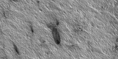
Plumes and spiders
At certain times in the Martian, dark eruptions of gas and dust occur. Wind often blows the material into a fan or a tail-like shape. During the winter, much frost accumulates. It freezes out directly onto the surface of the permanent polar cap, which is made of water ice covered with layers of dust and sand. The deposit begins as a layer of dusty CO2 frost. Over the winter, it recrystallizes and becomes denser. The dust and sand particles caught in the frost slowly sink. By the time temperatures rise in the spring, the frost layer has become a slab of semi-transparent ice about 3 feet thick, lying on a substrate of dark sand and dust. This dark material absorbs light and causes the ice to sublimate (turn directly into a gas). Eventually much gas accumulates and becomes pressurized. When it finds a weak spot, the gas escapes and blows out the dust. Speeds can reach 100 miles per hour.[85] Calculations show that the plumes are 20–80 meters high.[86][87] Dark channels can sometimes be seen; they are called "spiders".[88][89][90] The surface appears covered with dark spots when this process is occurring.[85][91]
Many ideas have been advanced to explain these features.[92][93][94][95][96][97] These features can be seen in some of the pictures below.
-
 Wide view of plumes, as seen by HiRISE under HiWish program. Many of the plumes show spiders when enlarged.
 -
 Plumes, as seen by HiRISE under HiWish program. Arrow shows a double plume. This may have been because of shifting winds.
 -
 Long plume, as seen by HiRISE under HiWish program
 -
 Spiders, as seen by HiRISE under HiWish program
 -
 Plumes and spiders, as seen by HiRISE under HiWish program
 -
 Plumes and spiders, as seen by HiRISE under HiWish program
 -
 Plumes and spiders, as seen by HiRISE under HiWish program
 -
 Wide view of plumes and spiders, as seen by HiRISE under HiWish program
 -
 Plumes and spiders, as seen by HiRISE under HiWish program


Upper plains unit
Remnants of a 50–100 meter thick mantling, called the upper plains unit, has been discovered in the mid-latitudes of Mars. First investigated in the Deuteronilus Mensae (Ismenius Lacus quadrangle) region, but it occurs in other places as well. The remnants consist of sets of dipping layers in craters and along mesas.[98] Sets of dipping layers may be of various sizes and shapes—some look like Aztec pyramids from Central America. Dipping layers are common in some regions of Mars. They may be the remains of mantle layers. Another idea for their origin was presented at 55th LPSC (2024) by an international team of researchers. They suggest that the layers are from past ice sheets.[99]
-
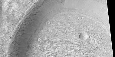
 Layered structure in crater that is probably what is left of a layered unit that once covered a much larger area. Material for this unit fell from the sky as ice-coated dust. The picture was taken by HiRISE, under the HiWish program. Picture is from Hellas quadrangle.

-
 Tilted layers, as seen by HiRISE under HiWish program. Location is Hellas quadrangle.
 -
 Tilted layers, as seen by HiRISE under HiWish program. Location is Hellas quadrangle.
 -
 Tilted layers, as seen by HiRISE under HiWish program. Location is Hellas quadrangle.


-
 Dipping layers, as seen by HiRISE under HiWish program
 -
 Layered features in crater, as seen by HiRISE under HiWish program
 -
 Layered structures, as seen by HiRISE under HiWish program
 -
 Close view of dipping layers along a mesa wall, as seen by HiRISE under HiWish program. Location is Ismenius Lacus quadrangle.
 -
 Close view of dipping layers in Ismenius Lacus quadrangle, as seen by HiRISE under HiWish program
 -
 Wide view of dipping layers in Ismenius Lacus quadrangle, as seen by HiRISE under HiWish program. Gullies are also visible at the bottom of the image.


This unit also degrades into brain terrain. Brain terrain is a region of maze-like ridges 3–5 meters high. Some ridges may consist of an ice core, so they may be sources of water for future colonists.
-
 Brain terrain, as seen by HiRISE under HiWish program. Location is Ismenius Lacus quadrangle.
 -
 Layered features and brain terrain, as seen by HiRISE under HiWish program. The upper plains unit often changes into brain terrain.
 -
 Brain terrain is forming from the breakdown of upper plains unit, as seen by HiRISE under HiWish program. Arrow points to a place where fractures are forming that will turn into brain terrain.
 -
 Brain terrain is forming from the breakdown of upper plains unit, as seen by HiRISE under HiWish program. Arrow points to a place where fractures are forming that will turn into brain terrain.


-
 Wide view of brain terrain being formed, as seen by HiRISE under HiWish program
 -
 Brain terrain being formed, as seen by HiRISE under HiWish program. Note: this is an enlargement of the previous image using HiView. Arrows indicate spots where brain terrain is beginning to form.
 -
 Brain terrain being formed, as seen by HiRISE under HiWish program. Note: this is an enlargement of a previous image using HiView. Arrows indicate spots where brain terrain is beginning to form.
 -
 Brain terrain being formed, as seen by HiRISE under HiWish program. Note: this is an enlargement of a previous image using HiView.
 -
 Brain terrain being formed, as seen by HiRISE under HiWish program. Note: this is an enlargement of a previous image using HiView.
 -
 Open and closed brain terrain with labels, as seen by HiRISE under HiWish program. Location is Ismenius Lacus quadrangle.
 -
 Brain terrain being formed, as seen by HiRISE under HiWish program. Location is Ismenius Lacus quadrangle.


-
 Wide view of brain terrain being formed, as seen by HiRISE under HiWish program
 -
 Brain terrain being formed, as seen by HiRISE under HiWish program. Note: this is an enlargement of the previous image using HiView.
 -
 Brain terrain being formed, as seen by HiRISE under HiWish program. Note: this is an enlargement of a previous image using HiView.


Some regions of the upper plains unit display large fractures and troughs with raised rims; such regions are called ribbed upper plains. Fractures are believed to have started with small cracks from stresses. Stress is suggested to initiate the fracture process since ribbed upper plains are common when debris aprons come together or near the edge of debris aprons—such sites would generate compressional stresses. Cracks exposed more surfaces, and consequently more ice in the material sublimates into the planet's thin atmosphere. Eventually, small cracks become large canyons or troughs.
-
 Well developed ribbed upper plains material. These start with small cracks that expand as ice sublimates from the surfaces of the crack. Picture was taken with HiRISE under HiWish program.
 -
 Dipping layers, as seen by HiRISE under HiWish program. Also, Ribbed Upper plains material is visible in the upper right of the picture. It is forming from the upper plains unit, and in turn is being eroded into brain terrain.


-
 Wide view showing ribbed terrain and brain terrain, as seen by HiRISE under HiWish program
 -
 Ribbed terrain being formed from upper plains unit, as seen by HiRISE under HiWish program. Formation begins with cracks that enhance sublimation. Box shows the size of football field.


Small cracks often contain small pits and chains of pits; these are thought to be from sublimation of ice in the ground.[100][101] Large areas of the Martian surface are loaded with ice that is protected by a meters thick layer of dust and other material. However, if cracks appear, a fresh surface will expose ice to the thin atmosphere.[102][103] In a short time, the ice will disappear into the cold, thin atmosphere in a process called sublimation. Dry ice behaves in a similar fashion on the Earth. On Mars sublimation has been observed when the Phoenix lander uncovered chunks of ice that disappeared in a few days.[38][104] In addition, HiRISE has seen fresh craters with ice at the bottom. After a time, HiRISE saw the ice deposit disappear.[105]
The upper plains unit is thought to have fallen from the sky. It drapes various surfaces, as if it fell evenly. As is the case for other mantle deposits, the upper plains unit has layers, is fine-grained, and is ice-rich. It is widespread; it does not seem to have a point source. The surface appearance of some regions of Mars is due to how this unit has degraded. It is a major cause of the surface appearance of lobate debris aprons.[101] The layering of the upper plains mantling unit and other mantling units are believed to be caused by major changes in the planet's climate. Models predict that the obliquity or tilt of the rotational axis has varied from its present 25 degrees to maybe over 80 degrees over geological time. Periods of high tilt will cause the ice in the polar caps to be redistributed and change the amount of dust in the atmosphere.[106][107][108]
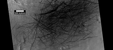
Linear ridge networks
Linear ridge networks are found in various places on Mars in and around craters.[109] Ridges often appear as mostly straight segments that intersect in a lattice-like manner. They are hundreds of meters long, tens of meters high, and several meters wide. It is thought that impacts created fractures in the surface, these fractures later acted as channels for fluids. Fluids cemented the structures. With the passage of time, surrounding material was eroded away, thereby leaving hard ridges behind. Since the ridges occur in locations with clay, these formations could serve as a marker for clay which requires water for its formation. Water here could have supported life.[110][111][112]
-
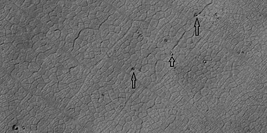
 Network of ridges, as seen by HiRISE under HiWish program. Ridges may be formed in various ways.
 -
 Color, close-up of ridges seen in previous image, as seen by HiRISE under HiWish program
 -
 Close-up and color image of linear ridge network, as seen by HiRISE under HiWish program
 -
 More linear ridge networks from same location as previous image, as seen by HiRISE under HiWish program
 -
 Linear ridge networks, as seen by HiRISE under HiWish program. Location is Amazonis quadrangle.
 -
 Linear ridge network, as seen by HiRISE under HiWish program. Location is Mare Tyrrhenum quadrangle.
 -
 Linear ridge network, as seen by HiRISE under HiWish program. Location is Casius quadrangle.
 -
 Wide view of ridge network, as seen by HiRISE under HiWish program. Location is Arcadia quadrangle.
 -
 Close view of ridge networks, as seen by HiRISE under HiWish program. Arrow points to small, straight ridge. Location is Arcadia quadrangle.


-
 Wide view of network of ridges, as seen by HiRISE under HiWish program. Portions of this image are enlarged in following images.
 -
 Close view of network of ridges, as seen by HiRISE under HiWish program. This is an enlargement of a previous image.
 -
 Close view of network of ridges, as seen by HiRISE under HiWish program. This is an enlargement of a previous image. Box shows the size of a football field.
 -
 Close view of network of ridges, as seen by HiRISE under HiWish program. This is an enlargement of a previous image.
 -
 Close view of ridges, as seen by HiRISE under HiWish program. This is an enlargement of a previous image. A small mesa in the image displays layers.
 -
 Close, color view of network of ridges, as seen by HiRISE under HiWish program. This is an enlargement of a previous image.


-
 Wide view of large ridge network, as seen by HiRISE under HiWish program
 -
 Close view of ridge network, as seen by HiRISE under HiWish program. Box shows size of football field.
 -
 Close, color view of ridges, as seen by HiRISE under HiWish program


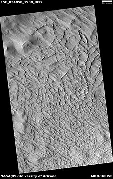
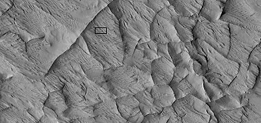
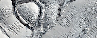
Fractured ground
Some places on Mars break up with large fractures that created a terrain with mesas and valleys. Some of these can be quite pretty.
-
 Wide view of fractured ground, as seen by HiRISE under HiWish program
 -
 Close view of fractured ground, as seen by HiRISE under HiWish program
 -
 Close view of fractured ground, as seen by HiRISE under HiWish program. Box shows size of football field. The boulders are the size of houses.
 -
 Close, color view of fractured ground, as seen by HiRISE under HiWish program


Mesas
-
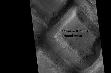 Mesa, as seen by HiRISE under HiWish program. This may make for a good race around a mesa someday in the far future.

-
 Mesa with layers, as seen by HiRISE under HiWish program. Location is Mare Acidalium quadrangle.
 -
 Close view of layers in mesa, as seen by HiRISE under HiWish program


-
 Wide view of layered buttes and small mesas, as seen by HiRISE under HiWish program. Some dark slope streaks are visible. Location is Aeolis quadrangle. Parts of this image are enlarged in next three pictures.
 -
 Layered mesa and mounds with dark slope streaks, as seen by HiRISE under HiWish program
 -
 Close view of layered small mesa with dark slope streak, as seen by HiRISE under HiWish program. Box shows the size of a football field.
 -
 Very close view of individual blocks breaking off layer in a butte, as seen by HiRISE under HiWish program. Blocks have angular shapes. Box shows size of football field.
 -
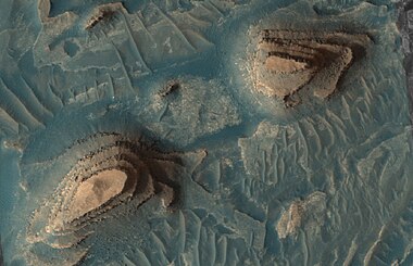 Layered mesa, as seen by HiRISE under HiWish program
 -
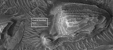 Layered mesa, as seen by HiRISE under HiWish program Box is the size of a football field.


Mesas formed by ground collapse
-
 Group of mesas, as seen by HiRISE under HiWish program. Oval box contains mesas that may have moved apart.
 -
 Enlarged view of a group of mesas, as seen by HiRISE under HiWish program. One surface is forming square shapes.
 -
 Mesas breaking up forming straight edges, as seen by HiRISE under HiWish program


Volcanoes under ice
There is evidence that volcanoes sometimes erupt under ice, as they do on Earth at times. What seems to happen it that much ice melts, the water escapes, and then the surface cracks and collapses. These exhibit concentric fractures and large pieces of ground that seemed to have been pulled apart.[113] Sites like this may have recently had held liquid water, hence they may be fruitful places to search for evidence of life.[114][115]
-
![Large group of concentric cracks, as seen by HiRISE, under HiWish program. Location is Ismenius Lacus quadrangle. Cracks were formed by a volcano under ice.[114]](//upload.wikimedia.org/wikipedia/commons/thumb/9/93/25755concentriccracks.jpg/380px-25755concentriccracks.jpg) Large group of concentric cracks, as seen by HiRISE, under HiWish program. Location is Ismenius Lacus quadrangle. Cracks were formed by a volcano under ice.[114]
Large group of concentric cracks, as seen by HiRISE, under HiWish program. Location is Ismenius Lacus quadrangle. Cracks were formed by a volcano under ice.[114] -
 Tilted layers formed when ground collapsed, as seen by HiRISE, under HiWish program
 -
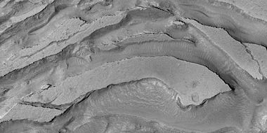 Tilted layers formed from ground collapse, as seen by HiRISE, under HiWish program
 -
 Mesas breaking up into blocks, as seen by HiRISE, under HiWish program
![Large group of concentric cracks, as seen by HiRISE, under HiWish program. Location is Ismenius Lacus quadrangle. Cracks were formed by a volcano under ice.[114]](http://upload.wikimedia.org/wikipedia/commons/thumb/9/93/25755concentriccracks.jpg/380px-25755concentriccracks.jpg)


Fractures forming blocks
In places large fractures break up surfaces. Sometimes straight edges are formed and large cubes are created by the fractures.
-
 Wide view of mesas that are forming fractures, as seen by HiRISE under HiWish program
 -
 Enlarged view of a part of previous image, as seen by HiRISE under HiWish program. The rectangle represents the size of a football field.
 -
 Close-up of blocks being formed, as seen by HiRISE under HiWish program
 -
 Close-up of blocks being formed, as seen by HiRISE under HiWish program. The rectangle represents the size of a football field, so blocks are the size of buildings.
 -
 Close-up of blocks being formed, as seen by HiRISE under HiWish program. Many long fractures are visible on the surface.
 -
 Surface breaking up, as seen by HiRISE under HiWish program. Near the top the surface is eroding into brain terrain.
 -
 Wide view showing light-toned feature that is breaking into blocks, as seen by HiRISE under HiWish program
 -
 Close view showing blocks being formed, as seen by HiRISE under HiWish program. Note: this is an enlargement of the previous image. Box represents size of football field.


Lava flows
-
 Lava flow in Tharsis quadrangle, as seen by HiRISE under HiWish program
 -
 Close-up of lava flow with labels, as seen by HiRISE under HiWish program. Note: this is an enlargement of the previous image of lava flows.
 -
 Lava flows with older and younger flows labeled, as seen by HiRISE under HiWish program
 -
 Edge of lava flow, as seen by HiRISE under HiWish program. Location is Solis Planum in Phoenicis Lacus quadrangle.
 -
 Wide view of streamlined shape and rafts of lava, as seen by HiRISE under HiWish program
 -
 Close view of lava rafts from previous image, as seen by HiRISE under HiWish program


Rootless cones
So-called "rootless cones" are caused by explosions of lava with ground ice under the flow.[116][117] The ice melts and turns into a vapor that expands in an explosion that produces a cone or ring. Featureslike these are found in Iceland, when lavas cover water-saturated substrates.[118][116][119]
-
 Wide view of field of rootless cones, as seen by HiRISE under HiWish program. Location is Elysium quadrangle.
 -
 Close view of rootless cones with tails that suggest lava was moving toward the Southwest over ice-rich ground, as seen by HiRISE under HiWish program
 -
 Close view of cones with the size of a football field shown, as seen by HiRISE under HiWish program
 -
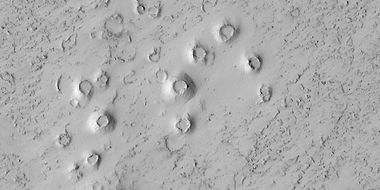 Close view of cones, as seen by HiRISE under HiWish program. These cones probably formed when hot lava flowed over ice-rich ground. The location is the Elysium quadrangle.
 -
 Rootless Cones, as seen by HiRISE under HiWish program. These group of rings or cones are believed to be caused by lava flowing over water ice or ground containing water ice. The ice quickly changes to steam which blows out a ring or cone. Here the kink in the chain may have been caused by the lava changing direction. Some of the forms do not have the shape of rings or cones because maybe the lava moved too quickly; thereby not allowing a complete cone shape to form. The location is the Elysium quadrangle.


Mud volcanoes
Some features look like volcanoes. Some of them may be mud volcanoes where pressurized mud is forced upward forming cones. These features may be places to look for life as they bring to the surface possible life that has been protected from radiation.
-
 Large field of cones that may be mud volcanoes, as seen by HiRISE under HiWish program. Location is Mare Acidalium quadrangle.
 -
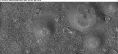 Close-up of possible mud volcanoes, as seen by HiRISE under HiWish program. Note: this is an enlargement of the previous image.


-
 Mud volcanoes, as seen by HiRISE under HiWish program. The location is Mare Acidalium quadrangle. There are many mud volcanoes in Mare Acidalium quadrangle.
 -
 Possible mud volcano, as seen by HiRISE under HiWish program. The location is Mare Acidalium quadrangle.


-
 Wide view of field of mud volcanoes, as seen by HiRISE under HiWish program
 -
 Close view of mud volcanoes, as seen by HiRISE under HiWish program
 -
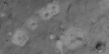 Close view of mud volcanoes and boulders, as seen by HiRISE under HiWish program


Hellas floor features
Strange terrain was discovered on parts of the floor of Hellas Planitia. Scientists are not sure of how it formed.
-
 Twisted bands on the floor of Hellas Planitia, as seen by HiRISE under HiWish program
 -
 Floor features in Hellas Planitia, as seen by HiRISE under HiWish program
 -
 Floor features in Hellas Planitia, as seen by HiRISE under HiWish program
 -
 Close view of groups of ridges on Hellas floor, as seen by HiRISE under HiWish program


Exhumed craters
Exhumed craters seem to be in the process of being uncovered.[120] It is believed that they formed, were covered over, and now are being exhumed as material is being eroded. When a crater forms, it will destroy what is under it. In the example below, only part of the crater is visible. if the crater came after the layered feature, it would have removed part of the feature and we would see the entire crater.
-
 Wide view of exhumed craters, as seen by HiRISE under HiWish program
 -
 Close view of exhumed crater, as seen by HiRISE under HiWish program. This crater is and was under a set of dipping layers.


How to suggest image
To suggest a location for HiRISE to image visit the site at http://www.uahirise.org/hiwish
In the sign up process you will need to come up with an ID and a password. When you choose a target to be imaged, you have to pick an exact location on a map and write about why the image should be taken. If your suggestion is accepted, it may take 3 months or more to see your image. You will be sent an email telling you about your images. The emails usually arrive on the first Wednesday of the month in the late afternoon.
See also
- Climate of Mars
- Common surface features of Mars
- Geology of Mars
- Glaciers
- Glaciers on Mars
- Barchan
- Groundwater on Mars
- Martian gullies
- Mud volcano
- Linear ridge networks
- Water on Mars
- Yardangs on Mars
References
- ^ "Public Invited To Pick Pixels On Mars". Mars Daily. January 22, 2010. Retrieved January 10, 2011.
- ^ "Take control of a Mars orbiter". 28 August 2018.
- ^ "HiWishing for 3D Mars images, part II".
- ^ Interview with Alfred McEwen on Planetary Radio, 3/15/2010
- ^ "Your Personal Photoshoot on Mars?". www.planetary.org. Retrieved 20 November 2018.
- ^ "NASA releases first eight "HiWish" selections of people's choice Mars images". TopNews. April 2, 2010. Archived from the original on March 12, 2012. Retrieved January 10, 2011.
- ^ McEwen, A. et al. 2016. THE FIRST DECADE OF HIRISE AT MARS. 47th Lunar and Planetary Science Conference (2016) 1372.pdf
- ^ Milliken, R.; Mustard, J.; Goldsby, D. (2003). "Viscous flow features on the surface of Mars: Observations from high-resolution Mars Orbiter Camera (MOC) images". J. Geophys. Res. 108 (E6): 5057. Bibcode:2003JGRE..108.5057M. doi:10.1029/2002JE002005.
- ^ Arfstrom, J; Hartmann, W. (2005). "Martian flow features, moraine-like ridges, and gullies: Terrestrial analogs and interrelationships". Icarus. 174 (2): 321–335. Bibcode:2005Icar..174..321A. doi:10.1016/j.icarus.2004.05.026.
- ^ Hubbard, B.; Milliken, R.; Kargel, J.; Limaye, A.; Souness, C. (2011). "Geomorphological characterisation and interpretation of a mid-latitude glacier-like form: Hellas Planitia, Mars". Icarus. 211 (1): 330–346. Bibcode:2011Icar..211..330H. doi:10.1016/j.icarus.2010.10.021.
- ^ "HiRISE - Spider Webs (ESP_046359_1250)". www.uahirise.org. Retrieved 20 November 2018.
- ^ Soare, E., et al. 2019. Possible (closed system) pingo and ice-wedge/thermokarst complexes at the mid latitudes of Utopia Planitia, Mars. Icarus. https://doi.org/10.1016/j.icarus.2019.03.010
- ^ Baker, V. 1982. The Channels of Mars. Univ. of Tex. Press, Austin, TX
- ^ NASA.gov
- ^ "HiRISE - Candidate Landing Site for 2020 Mission in Firsoff Crater (ESP_039404_1820)". hirise.lpl.arizona.edu. Retrieved 20 November 2018.
- ^ Pondrelli, M., A. Rossi, L. Deit, S. van Gasselt, F. Fueten, E. Hauber, B. Cavalazzi, M. Glamoclija, and F. Franchi. 2014. A PROPOSED LANDING SITE FOR THE 2020 MARS MISSION: FIRSOFF CRATER. http://marsnext.jpl.nasa.gov/workshops/2014_05/33_Pondrelli_Firsoff_LS2020.pdf
- ^ Golombek, J. et al. 2016. Downselection of landing Sites for the Mars 2020 Rover Mission. 47th Lunar and Planetary Science Conference (2016). 2324.pdf
- ^ McEwen, A.; et al. (2014). "Recurring slope lineae in equatorial regions of Mars". Nature Geoscience. 7 (1): 53–58. Bibcode:2014NatGe...7...53M. doi:10.1038/ngeo2014.
- ^ McEwen, A.; et al. (2011). "Seasonal Flows on Warm Martian Slopes". Science. 333 (6043): 740–743. Bibcode:2011Sci...333..740M. doi:10.1126/science.1204816. PMID 21817049. S2CID 10460581.
- ^ "recurring slope lineae - Red Planet Report". redplanet.asu.edu. Retrieved 20 November 2018.
- ^ Bishop, J. L.; Yeşilbaş, M.; Hinman, N. W.; Burton, Z. F. M.; Englert, P. A. J.; Toner, J. D.; McEwen, A. S.; Gulick, V. C.; Gibson, E. K.; Koeberl, C. (2021). "Martian subsurface cryosalt expansion and collapse as trigger for landslides". Science Advances. 7 (6). Bibcode:2021SciA....7.4459B. doi:10.1126/sciadv.abe4459. PMC 7857681. PMID 33536216. S2CID 231805052.
- ^ Bishop, J., et al. 2021. Martian subsurface cryosalt expansion and collapse as trigger for landslides. Science Advances. Vol. 7, no. 6, eabe4459 DOI: 10.1126/sciadv.abe4459
- ^ "Lines on Mars could be created by salty water triggering landslides".
- ^ Stillman, D., et al. 2017. Characteristics of the numerous and widespread recurring slope lineae (RSL) in Valles Marineris, Mars. Icarus. Volume 285. Pages 195-210
- ^ "HiRISE | High Resolution Imaging Science Experiment". Hirise.lpl.arizona.edu?psp_008437_1750. Retrieved 2012-08-04.
- ^ Malin, M.; Edgett, K. (2000). "Evidence for recent groundwater seepage and surface runoff on Mars". Science. 288 (5475): 2330–2335. Bibcode:2000Sci...288.2330M. doi:10.1126/science.288.5475.2330. PMID 10875910.
- ^ a b Hecht, M (2002). "Metastability of water on Mars". Icarus. 156 (2): 373–386. Bibcode:2002Icar..156..373H. doi:10.1006/icar.2001.6794.
- ^ a b Mustard, J.; et al. (2001). "Evidence for recent climate change on Mars from the identification of youthful near-surface ground ice". Nature. 412 (6845): 411–414. Bibcode:2001Natur.412..411M. doi:10.1038/35086515. PMID 11473309. S2CID 4409161.
- ^ Pollack, J.; Colburn, D.; Flaser, F.; Kahn, R.; Carson, C.; Pidek, D. (1979). "Properties and effects of dust suspended in the martian atmosphere". J. Geophys. Res. 84: 2929–2945. Bibcode:1979JGR....84.2929P. doi:10.1029/jb084ib06p02929.
- ^ "HiRISE - Layered Mantling Deposits in the Northern Mid-Latitudes (ESP_048897_2125)". www.uahirise.org. Retrieved 20 November 2018.
- ^ Boynton, W.; et al. (2002). "Distribution of hydrogen in the nearsurface of Mars: Evidence for sub-surface ice deposits". Science. 297 (5578): 81–85. Bibcode:2002Sci...297...81B. doi:10.1126/science.1073722. PMID 12040090. S2CID 16788398.
- ^ Kuzmin, R; et al. (2004). "Regions of potential existence of free water (ice) in the near-surface martian ground: Results from the Mars Odyssey High-Energy Neutron Detector (HEND)". Solar System Research. 38 (1): 1–11. Bibcode:2004SoSyR..38....1K. doi:10.1023/b:sols.0000015150.61420.5b. S2CID 122295205.
- ^ Mitrofanov, I. et al. 2007a. Burial depth of water ice in Mars permafrost subsurface. In: LPSC 38, Abstract #3108. Houston, TX.
- ^ Mitrofanov, I.; et al. (2007b). "Water ice permafrost on Mars: Layering structure and subsurface distribution according to HEND/Odyssey and MOLA/MGS data". Geophys. Res. Lett. 34 (18): 18. Bibcode:2007GeoRL..3418102M. doi:10.1029/2007GL030030. S2CID 45615143.
- ^ Mangold, N.; et al. (2004). "Spatial relationships between patterned ground and ground ice detected by the neutron spectrometer on Mars" (PDF). J. Geophys. Res. 109 (E8): E8. Bibcode:2004JGRE..109.8001M. doi:10.1029/2004JE002235.
- ^ Feldman, W.; et al. (2002). "Global distribution of neutrons from Mars: Results from Mars Odyssey". Science. 297 (5578): 75–78. Bibcode:2002Sci...297...75F. doi:10.1126/science.1073541. PMID 12040088. S2CID 11829477.
- ^ Feldman, W.; et al. (2008). "North to south asymmetries in the water-equivalent hydrogen distribution at high latitudes on Mars". J. Geophys. Res. 113 (E8). Bibcode:2008JGRE..113.8006F. doi:10.1029/2007JE003020. hdl:2027.42/95381.
- ^ a b Bright Chunks at Phoenix Lander's Mars Site Must Have Been Ice – Official NASA press release (19.06.2008)
- ^ "Confirmation of Water on Mars". Nasa.gov. 2008-06-20. Retrieved 2012-07-13.
- ^ Mutch, T.A., and 24 colleagues, 1976. The surface of Mars: The view from the Viking2 lander Science 194 (4271), 1277–1283.
- ^ Mutch, T.; et al. (1977). "The geology of the Viking Lander 2 site". J. Geophys. Res. 82 (28): 4452–4467. Bibcode:1977JGR....82.4452M. doi:10.1029/js082i028p04452.
- ^ Levy, J.; et al. (2009). "Thermal contraction crack polygons on Mars: Classification, distribution, and climate implications from HiRISE observations". J. Geophys. Res. 114 (E1). Bibcode:2009JGRE..114.1007L. doi:10.1029/2008JE003273.
- ^ Washburn, A. 1973. Periglacial Processes and Environments. St. Martin's Press, New York, pp. 1–2, 100–147.
- ^ Mellon, M. 1997. Small-scale polygonal features on Mars: Seasonal thermal contraction cracks in permafrost J. Geophys. Res. 102, 25,617-25,628.
- ^ a b Mangold, N (2005). "High latitude patterned grounds on Mars: Classification, distribution and climatic control". Icarus. 174 (2): 336–359. Bibcode:2005Icar..174..336M. doi:10.1016/j.icarus.2004.07.030.
- ^ Marchant, D.; Head, J. (2007). "Antarctic dry valleys: Microclimate zonation, variable geomorphic processes, and implications for assessing climate change on Mars". Icarus. 192 (1): 187–222. Bibcode:2007Icar..192..187M. doi:10.1016/j.icarus.2007.06.018.
- ^ "Refubium - Suche" (PDF). www.diss.fu-berlin.de. Retrieved 20 November 2018.
- ^ Kostama, V.-P.; Kreslavsky, Head (2006). "Recent high-latitude icy mantle in the northern plains of Mars: Characteristics and ages of emplacement". Geophys. Res. Lett. 33 (11): L11201. Bibcode:2006GeoRL..3311201K. doi:10.1029/2006GL025946. S2CID 17229252.
- ^ Malin, M.; Edgett, K. (2001). "Mars Global Surveyor Mars Orbiter Camera: Interplanetary cruise through primary mission". J. Geophys. Res. 106 (E10): 23429–23540. Bibcode:2001JGR...10623429M. doi:10.1029/2000je001455.
- ^ Milliken, R.; et al. (2003). "Viscous flow features on the surface of Mars: Observations from high-resolution Mars Orbiter Camera (MOC) images". J. Geophys. Res. 108 (E6): E6. Bibcode:2003JGRE..108.5057M. doi:10.1029/2002JE002005.
- ^ Kreslavsky, M.; Head, J. (2000). "Kilometer-scale roughness on Mars: Results from MOLA data analysis". J. Geophys. Res. 105 (E11): 26695–26712. Bibcode:2000JGR...10526695K. doi:10.1029/2000je001259.
- ^ Seibert, N.; Kargel, J. (2001). "Small-scale martian polygonal terrain: Implications for liquid surface water". Geophys. Res. Lett. 28 (5): 899–902. Bibcode:2001GeoRL..28..899S. doi:10.1029/2000gl012093. S2CID 129590052.
- ^ Kreslavsky, M.A., Head, J.W., 2002. High-latitude Recent Surface Mantle on Mars: New Results from MOLA and MOC. European Geophysical Society XXVII, Nice.
- ^ Head, J.W.; Mustard, J.F.; Kreslavsky, M.A.; Milliken, R.E.; Marchant, D.R. (2003). "Recent ice ages on Mars". Nature. 426 (6968): 797–802. Bibcode:2003Natur.426..797H. doi:10.1038/nature02114. PMID 14685228. S2CID 2355534.
- ^ Steep Slopes on Mars Reveal Structure of Buried Ice. NASA Press Release. 11 January 2018.
- ^ Ice cliffs spotted on Mars. Science News. Paul Voosen. 11 January 2018.
- ^ "Exposed subsurface ice sheets in the Martian mid-latitudes". www.slideshare.net. 13 January 2018. Retrieved 20 November 2018.
- ^ "Steep Slopes on Mars Reveal Structure of Buried Ice - SpaceRef". spaceref.com. 11 January 2018. Retrieved 20 November 2018.[permanent dead link]
- ^ Dundas, Colin M.; et al. (2018). "Exposed subsurface ice sheets in the Martian mid-latitudes". Science. 359 (6372): 199–201. Bibcode:2018Sci...359..199D. doi:10.1126/science.aao1619. PMID 29326269. S2CID 206662378.
- ^ a b Supplementary Materials Exposed subsurface ice sheets in the Martian mid-latitudes Colin M. Dundas, Ali M. Bramson, Lujendra Ojha, James J. Wray, Michael T. Mellon, Shane Byrne, Alfred S. McEwen, Nathaniel E. Putzig, Donna Viola, Sarah Sutton, Erin Clark, John W. Holt
- ^ Lefort, A.; Russell, P. S.; Thomas, N.; McEwen, A. S.; Dundas, C. M.; Kirk, R. L. (2009). "Observations of periglacial landforms in Utopia Planitia with the High Resolution Imaging Science Experiment (HiRISE)". Journal of Geophysical Research. 114 (E4): E04005. Bibcode:2009JGRE..114.4005L. doi:10.1029/2008JE003264. S2CID 129442086.
- ^ Morgenstern, A; Hauber, E; Reiss, D; van Gasselt, S; Grosse, G; Schirrmeister, L (2007). "Deposition and degradation of a volatile-rich layer in Utopia Planitia, and implications for climate history on Mars" (PDF). Journal of Geophysical Research: Planets. 112 (E6): E06010. Bibcode:2007JGRE..112.6010M. doi:10.1029/2006JE002869. Archived from the original (PDF) on 2011-10-04.
- ^ Lefort, A.; Russell, P.S.; Thomas, N. (2010). "Scalloped terrains in the Peneus and Amphitrites Paterae region of Mars as observed by HiRISE". Icarus. 205 (1): 259. Bibcode:2010Icar..205..259L. doi:10.1016/j.icarus.2009.06.005.
- ^ Zanetti, M.; Hiesinger, H.; Reiss, D.; Hauber, E.; Neukum, G. (2009). "Scalloped Depression Development on Malea Planum and the Southern Wall of the Hellas Basin, Mars" (PDF). Lunar and Planetary Science. 40. p. 2178, abstract 2178. Bibcode:2009LPI....40.2178Z.
- ^ http://hiroc.lpl.arizona.edu/images/PSP?diafotizo.php?ID=PSP_002296_1215[permanent dead link]
- ^ "Huge Underground Ice Deposit on Mars Is Bigger Than New Mexico". Space.com. 22 November 2016. Retrieved 20 November 2018.
- ^ Staff (November 22, 2016). "Scalloped Terrain Led to Finding of Buried Ice on Mars". NASA. Retrieved November 23, 2016.
- ^ "Lake of frozen water the size of New Mexico found on Mars – NASA". The Register. November 22, 2016. Retrieved November 23, 2016.
- ^ Bramson, A, et al. 2015. Widespread excess ice in Arcadia Planitia, Mars. Geophysical Research Letters: 42, 6566-6574
- ^ "Widespread, Thick Water Ice found in Utopia Planitia, Mars | Cassie Stuurman". Archived from the original on 2016-11-30. Retrieved 2016-11-29.
- ^ Stuurman, C., et al. 2016. SHARAD detection and characterization of subsurface water ice deposits in Utopia Planitia, Mars. Geophysical Research Letters: 43, 9484_9491.
- ^ http://hirise.lpl.eduPSP_008508_1870[permanent dead link]
- ^ Bleacher, J. and S. Sakimoto. Pedestal Craters, A Tool For Interpreting Geological Histories and Estimating Erosion Rates. LPSC
- ^ "Mars Odyssey Mission THEMIS: Feature Image: Pedestal Craters in Utopia". Archived from the original on 2010-01-18. Retrieved 2010-03-26.
- ^ McCauley, J. F. (1973). "Mariner 9 evidence for wind erosion in the equatorial and mid-latitude regions of Mars". Journal of Geophysical Research. 78 (20): 4123–4137. Bibcode:1973JGR....78.4123M. doi:10.1029/JB078i020p04123.
- ^ Baker, David M.H.; Carter, Lynn M. (2019). "Probing supraglacial debris on Mars 2: Crater morphology". Icarus. 319: 264–280. Bibcode:2019Icar..319..264B. doi:10.1016/j.icarus.2018.09.009. S2CID 126156734.
- ^ Baker, D. and L. Carter. 2019. Probing supraglacial debris on Mars 2: Crater morphology. Icarus. Volume 319. Pages 264-280
- ^ Levy, J. et al. 2008. Origin and arrangement of boulders on the martian northern plains: Assessment of emplacement and modification environments> In 39th Lunar and Planetary Science Conference, Abstract #1172. League City, TX
- ^ Mars Exploration Rover Mission: Press Release Images: Spirit. Marsrovers.jpl.nasa.gov. Retrieved on 7 August 2011.
- ^ "HiRISE - Dust Devils Dancing on Dunes (PSP_005383_1255)". hirise.lpl.arizona.edu. Retrieved 20 November 2018.
- ^ Reiss, D.; et al. (2011). "Multitemporal observations of identical active dust devils on Mars with High Resolution Stereo Camera (HRSC) and Mars Orbiter Camera (MOC)". Icarus. 215 (1): 358–369. Bibcode:2011Icar..215..358R. doi:10.1016/j.icarus.2011.06.011.
- ^ Ward, A. Wesley (20 November 1979). "Yardangs on Mars: Evidence of recent wind erosion". Journal of Geophysical Research. 84 (B14): 8147–8166. Bibcode:1979JGR....84.8147W. doi:10.1029/JB084iB14p08147.
- ^ esa. "'Yardangs' on Mars". Retrieved 20 November 2018.
- ^ "Medusae Fossae Formation - Mars Odyssey Mission THEMIS". themis.asu.edu. Retrieved 20 November 2018.
- ^ a b "Gas jets spawn dark 'spiders' and spots on Mars icecap - Mars Odyssey Mission THEMIS". themis.asu.edu. Retrieved 20 November 2018.
- ^ Thomas, N., G. Portyankina, C.J. Hansen, A. Pommerol. 2011. HiRISE observations of gas sublimation-driven activity in Mars' southern polar regions: IV. Fluid dynamics models of CO2 jets Icarus: 212, pp. 66–85
- ^ Buhler, Peter, Andrew Ingersoll, Bethany Ehlmann, Cale Fassett, James Head. 2017. How the martian residual south polar cap develops quasi-circular and heart-shaped pits, troughs, and moats. Icarus: 286, 69–93
- ^ Benson, M. 2012. Planetfall: New Solar System Visions
- ^ "Spiders invade Mars". Astrobiology Magazine. 17 August 2006. Retrieved 20 November 2018.
- ^ Kieffer H, Christensen P, Titus T. 2006 Aug 17. CO2 jets formed by sublimation beneath translucent slab ice in Mars' seasonal south polar ice cap. Nature: 442(7104):793-6.
- ^ "Thawing 'Dry Ice' Drives Groovy Action on Mars". NASA/JPL. Retrieved 20 November 2018.
- ^ Kieffer, H. H. (2000). "Mars Polar Science 2000 - Annual Punctuated CO2 Slab-ice and Jets on Mars" (PDF). Retrieved 6 September 2009.
{{cite journal}}: Cite journal requires|journal=(help) - ^ Kieffer, Hugh H. (2003). "Third Mars Polar Science Conference (2003)- Behavior of Solid CO" (PDF). Retrieved 6 September 2009.
{{cite journal}}: Cite journal requires|journal=(help) - ^ Portyankina, G., ed. (2006). "Fourth Mars Polar Science Conference - Simulations of Geyser-Type Eruptions in Cryptic Region of Martian South" (PDF). Retrieved 11 August 2009.
{{cite journal}}: Cite journal requires|journal=(help) - ^ Sz. Bérczi; et al., eds. (2004). "Lunar and Planetary Science XXXV (2004) - Stratigraphy of Special Layers – Transient Ones on Permeable Ones: Examples" (PDF). Retrieved 12 August 2009.
{{cite journal}}: Cite journal requires|journal=(help) - ^ "NASA Findings Suggest Jets Bursting From Martian Ice Cap". Jet Propulsion Laboratory. NASA. 16 August 2006. Archived from the original on 25 February 2021. Retrieved 11 August 2009.
- ^ C.J. Hansen; N. Thomas; G. Portyankina; et al. (2010). "HiRISE observations of gas sublimation-driven activity in Mars' southern polar regions: I. Erosion of the surface" (PDF). Icarus. 205 (1): 283–295. Bibcode:2010Icar..205..283H. doi:10.1016/j.icarus.2009.07.021. Retrieved 26 July 2010.
- ^ Carr, M. 2001.
- ^ Blanc, E., et al. 2024. ORIGIN OF WIDESPREAD LAYERED DEPOSITS ASSOCIATED WITH MARTIAN DEBRIS COVERED GLACIERS. 55th LPSC (2024). 1466.pdf
- ^ Morgenstern, A., et al. 2007
- ^ a b Baker, D.; Head, J. (2015). "Extensive Middle Amazonian mantling of debris aprons and plains in Deuteronilus Mensae, Mars: Implication for the record of mid-latitude glaciation". Icarus. 260: 269–288. Bibcode:2015Icar..260..269B. doi:10.1016/j.icarus.2015.06.036.
- ^ Mangold, N (2003). "Geomorphic analysis of lobate debris aprons on Mars at Mars Orbiter Camera scale: Evidence for ice sublimation initiated by fractures". J. Geophys. Res. 108 (E4): 8021. Bibcode:2003JGRE..108.8021M. doi:10.1029/2002je001885.
- ^ Levy, J. et al. 2009. Concentric
- ^ "NASA - Bright Chunks at Phoenix Lander's Mars Site Must Have Been Ice". www.nasa.gov. Retrieved 20 November 2018.
- ^ Byrne, S.; et al. (2009). "Distribution of Mid-Latitude Ground Ice on Mars from New Impact Craters". Science. 325 (5948): 1674–1676. Bibcode:2009Sci...325.1674B. doi:10.1126/science.1175307. PMID 19779195. S2CID 10657508.
- ^ Head, J. et al. 2003.
- ^ Madeleine, et al. 2014.
- ^ Schon; et al. (2009). "A recent ice age on Mars: Evidence for climate oscillations from regional layering in mid-latitude mantling deposits". Geophys. Res. Lett. 36 (15): L15202. Bibcode:2009GeoRL..3615202S. doi:10.1029/2009GL038554. S2CID 18570952.
- ^ Head, J.; Mustard, J. (2006). "Breccia dikes and crater-related faults in impact craters on Mars: Erosion and exposure on the floor of a crater 75 km in diameter at the dichotomy boundary". Meteorit. Planet Science. 41 (10): 1675–1690. Bibcode:2006M&PS...41.1675H. doi:10.1111/j.1945-5100.2006.tb00444.x. S2CID 12036114.
- ^ Mangold; et al. (2007). "Mineralogy of the Nili Fossae region with OMEGA/Mars Express data: 2. Aqueous alteration of the crust". J. Geophys. Res. 112 (E8). Bibcode:2007JGRE..112.8S04M. doi:10.1029/2006JE002835. S2CID 15188454.
- ^ Mustard; et al. (2007). "Mineralogy of the Nili Fossae region with OMEGA/Mars Express data: 1. Ancient impact melt in the Isidis Basin and implications for the transition from the Noachian to Hesperian". J. Geophys. Res. 112 (E8). Bibcode:2007JGRE..112.8S03M. doi:10.1029/2006JE002834.
- ^ Mustard; et al. (2009). "Composition, Morphology, and Stratigraphy of Noachian Crust around the Isidis Basin" (PDF). J. Geophys. Res. 114 (7). Bibcode:2009JGRE..114.0D12M. doi:10.1029/2009JE003349.
- ^ Smellie, J., B. Edwards. 2016. Glaciovolcanism on Earth and Mars. Cambridge University Press.
- ^ a b Levy, J., et al. 2017. Candidate volcanic and impact-induced ice depressions on Mars. Icarus: 285, 185-194.
- ^ University of Texas at Austin. "A funnel on Mars could be a place to look for life." ScienceDaily. ScienceDaily, 10 November 2016. <sciencedaily.com/releases/2016/11/161110125408.htm>.
- ^ a b "PSR Discoveries: Rootless cones on Mars". www.psrd.hawaii.edu. Retrieved 20 November 2018.
- ^ Lanagan, P., A. McEwen, L. Keszthelyi, and T. Thordarson. 2001. Rootless cones on Mars indicating the presence of shallow equatorial ground ice in recent times, Geophysical Research Letters: 28, 2365-2368.
- ^ S. Fagents1, a., P. Lanagan, R. Greeley. 2002. Rootless cones on Mars: a consequence of lava-ground ice interaction. Geological Society, Londo. Special Publications: 202, 295-317.
- ^ Jaeger, W., L. Keszthelyi, A. McEwen, C. Dundas, P. Russell, and the HiRISE team. 2007. EARLY HiRISE OBSERVATIONS OF RING/MOUND LANDFORMS IN ATHABASCA VALLES, MARS. Lunar and Planetary Science XXXVIII 1955.pdf.
- ^ "Exhumed Craters near Kaiser".
Further reading
- Lorenz, R. 2014. The Dune Whisperers. The Planetary Report: 34, 1, 8-14
- Lorenz, R., J. Zimbelman. 2014. Dune Worlds: How Windblown Sand Shapes Planetary Landscapes. Springer Praxis Books / Geophysical Sciences.
- Grotzinger, J. and R. Milliken (eds.). 2012. Sedimentary Geology of Mars. SEPM.
External links
- HiRISE images from HiWish Program
- /0:48 Zooming in on Mars with HiRISE images from HiWish program
- Features of Mars with HiRISE under HiWish program Shows nearly all major features discovered on Mars. This would be good for teachers covering Mars.
- A trip to Mars with Hubble, Viking, and HiRISE
- Mars through HiRISE under the HiWish program
- Beautiful Mars as seen by HiRISE under HiWish program
- Martian Ice - Jim Secosky - 16th Annual International Mars Society Convention
- Martian Geology - Jim Secosky - 16th Annual International Mars Society Convention
- Walks on Mars - Jim Secosky - 16th Annual International Mars Society Convention
- How to Explore Mars without Leaving Your Chair - Jim Secosky - 23rd Annual Mars Society Convention
- Stillman, D., et al. 2017. Characteristics of the numerous and widespread recurring slope lineae (RSL) in Valles Marineris, Mars. Icarus. Volume 285. Pages 195-210
- McEwen, A., et al. 2024. The high-resolution imaging science experiment (HiRISE) in the MRO extended science phases (2009–2023). Icarus. Available online 16 September 2023, 115795. In Press.
- v
- t
- e


Portal:
 Solar System


