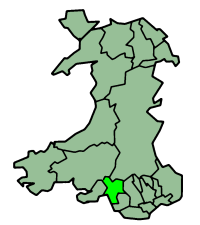
Neath Port Talbot
Unitaire autoriteit in Wales  | |||
|---|---|---|---|
 | |||
| Coördinaten | 51°38'44"NB, 3°44'42"WL | ||
| Algemeen | |||
| Oppervlakte | 441,3072[1] km² | ||
| Inwoners | 142906 (2018)[2] (324 inw./km²) | ||
| Bestuurlijke status | county borough | ||
| Welsh sprekend | 28,8% | ||
| Overig | |||
| ISO 3166-2 | GB-NTL | ||
| ONS-code | W06000012 | ||
| Officiële website | neath-porttalbot.gov.uk | ||
| |||

Neath Port Talbot (Welsh: Castell-nedd Port Talbot) is een county borough in het zuiden van Wales, gelegen in het ceremoniële behouden graafschap West Glamorgan en het historische graafschap Glamorgan. De county borough heeft 143.000 inwoners.
Plaatsen
- Baglan
- Briton Ferry
- Neath
- Pontardawe
- Port Talbot (hoofdstad)
| Bronnen, noten en/of referenties |

Graafschappen: Anglesey · Carmarthenshire · Ceredigion · Denbighshire · Flintshire · Gwynedd · Monmouthshire · Pembrokeshire · Powys
County boroughs: Blaenau Gwent · Bridgend · Caerphilly · Conwy · Merthyr Tydfil · Neath Port Talbot · Rhondda Cynon Taf · Torfaen · Vale of Glamorgan · Wrexham
Steden: Cardiff · Newport · Swansea
Zie ook: behouden graafschappen (preserved counties) en de historische graafschappen


