County Bexar, Texas
| Bexar County, Texas | |
|---|---|
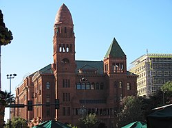 The Bexar County Courthouse in San Antonio. | |
 Lokasi di negara bagian Texas | |
 Lokasi negara bagian Texas di Amerika Serikat | |
| Didirikan | December 20 1836 |
| Seat | San Antonio |
| Wilayah | |
| • Keseluruhan | 1.257 sq mi (3.256 km2) |
| • Daratan | 1.247 sq mi (3.230 km2) |
| • Perairan | 10 sq mi (26 km2), 0.78% |
| Populasi | |
| • (2010) | 1.714.773 |
| • Kepadatan | 1.375/sq mi (531/km²) |
| Situs web | www |
Bexar County adalah county yang terletak di negara bagian Texas, Amerika Serikat. Jumlah penduduk pada tahun sebesar jiwa.
Jalan utama
 Interstate 10
 Interstate 35
 Interstate 37
 Interstate 410
 U.S. Highway 87
 U.S. Highway 90
 U.S. Highway 181
 U.S. Highway 281
 State Highway 16


Pranala luar
- Bexar County government's website
- Bexar County dari Handbook of Texas Online
- Historic Bexar County materials, hosted by the Portal to Texas History.
 | Bandera County | Kendall County and Comal County | Guadalupe County | |
| Medina County |  | |||
| ||||
 | ||||
| Atascosa County | Wilson County |

Templat:Bexar County, Texas
 Negara bagian Texas Negara bagian Texas | |
|---|---|
Austin (ibu kota) | |
| Topik |
|
| Region |
|
| Wilayah metro |
|
| County |
|
 | Artikel bertopik geografi atau tempat Amerika Serikat ini adalah sebuah rintisan. Anda dapat membantu Wikipedia dengan mengembangkannya. |
- l
- b
- s


