Youghiogheny River Lake
Reservoir in and Garrett County, Maryland
39°47′52″N 079°22′09″W / 39.79778°N 79.36917°W / 39.79778; -79.36917The Youghiogheny River Lake is a flood control reservoir that is located in southwestern Pennsylvania and western Maryland. It is a significant tourist attraction that brings in more than one million visitors a year to the area.[3]
History and notable features
This lake was formed in 1944 by the damming of the Youghiogheny River upstream from Confluence, Pennsylvania.[3]
The Youghiogheny Dam is an earthen structure, 184 feet (56 m) high and 1,610 feet (490 m) long at its crest, that is owned and operated by the United States Army Corps of Engineers.[4]
The reservoir's normal surface area is approximately 4.4 square miles (11 km2), and it has a maximum capacity of 300,000 acre-feet (370,000,000 m3), although its normal storage level is 149,300 acre-feet (184,200,000 m3).[4]
The dam facilitates flood control, improves river flow and provides twelve megawatts of hydroelectric power.[1]
U.S. Route 40 crosses the lake between Jockey Hollow on the Fayette County side and Somerfield on the Somerset County side.[5]
Somerfield was laid out on the western edge of Addison Township, Somerset County circa 1816 by Philip D. Smyth, who originally named the settlement Smythfield.[6] Somerfield was abandoned, razed, and inundated when the reservoir was filled during the 1940s.
The stone Great Crossings Bridge of the National Road, which crossed the Youghiogheny at Somerfield, is visible at extremely low water levels.[7] The triple-arch sandstone bridge was constructed between 1815 and 1818 by James Kinkead, James Beck, and Evan Evans.[7][8]
Gallery
-
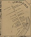 Somerfield, 1860 (note orientation of map: north at bottom)

References
- ^ a b Youghiogheny River Lake at the U.S. Army Corps of Engineers
- ^ U.S. Geological Survey Geographic Names Information System: Youghiogheny River Lake
- ^ a b Palmer, Tim (1984). Youghiogheny, Appalachian River. Pittsburgh: University of Pittsburgh Press. p. 92. ISBN 978-0-82293-495-0.
- ^ a b United States Department of the Interior Geological Survey (1968). Water Resources Data for Pennsylvania: Part 1 Surface Water Records. Harrisburg: United States Geological Survey. p. 248.
- ^ "Youghiogheny River Lake Project Map". Pittsburgh District, U.S. Army Corps of Engineers. Retrieved June 2, 2020.
- ^ History of Bedford, Somerset and Fulton Counties, Pennsylvania. Chicago: Waterman, Watkins & Co. 1884. p. 572.
- ^ a b Lowry, Patricia (January 7, 1999). "A bridge to the 19th century: Falling water-level of Youghiogheny unearths ghost town, historical crossing". Pittsburgh Post-Gazette. Retrieved June 1, 2020.
{{cite news}}: CS1 maint: date and year (link) - ^ Heberling, Scott D. (2010). Historic Bridges of Somerset County, Pennsylvania (PDF). Harrisburg, PA: Pennsylvania Dept. of Transportation. p. 7.
Wikimedia Commons has media related to Youghiogheny River Lake.
- v
- t
- e
Waters of Maryland
- Assawoman
- Chesapeake
- Chincoteague
- Curtis Bay
- Eastern
- Fishing
- Herring
- Isle of Wight
- Mallows
- Newport
- Pocomoke
- Sinepuxent
- Tangier
- Anacostia
- Annemessex (Big)
- Annemessex (Little)
- Back
- Bird
- Blackwater
- Blackwater (Little)
- Bohemia
- Bush
- Casselman
- Chester
- Chicamacomico
- Choptank
- Choptank (Little)
- Christina
- Corsica
- Elk
- Front
- Gunpowder
- Hawlings
- Jones Falls
- Magothy
- Magothy (Little)
- Manokin
- Middle
- Miles
- Monocacy
- Monocacy (Little)
- Nanticoke
- North
- North East
- Patapsco
- Patuxent
- Pocomoke
- Port Tobacco
- Potomac
- Rhode
- St. Martin
- St. Marys
- Sassafras
- Savage
- Severn
- South
- Susquehanna
- Transquaking
- Tred Avon
- Warwick
- West
- Wicomico (Potomac)
- Wicomico
- Wye
- Wye East
- Youghiogheny
runs,
streams
- Antietam
- Alloway
- Arundel Cove
- Ballenger
- Bear (Patapsco)
- Bear (Sideling Hill)
- Bear (Youghiogheny)
- Beaverdam
- Bennett
- Big Hunting
- Big Pipe
- Bodkin
- Bonnie Branch
- Bread and Cheese
- Broad (Choptank)
- Broad (Potomac)
- Broad (Susquehanna)
- Broad Run
- Budds
- Bush
- Cabin John
- Carroll
- Catoctin
- Catoctin (Little)
- Chicamuxen
- Collington Branch
- Conococheague
- Conococheague (Little)
- Conowingo
- Cuckold
- Curtis
- Deep Run
- Deer
- Dividing
- Dorsey Run
- Double Pipe
- Dry Seneca
- Dueling
- Dundee
- Evitts
- Fifteenmile
- Fishing
- Flintstone
- Frog Mortar
- Furnace
- Georges
- Great Seneca
- Green Branch
- Greys
- Gwynns Falls
- Harris
- Henson
- Herbert Run
- Herring Run
- Honga
- Hunting (Little)
- Indian (Anacostia)
- Indian (Patuxent)
- Israel
- Laurel Run
- Licking
- Linganore
- Little Falls
- Little Falls Branch
- Little Pipe
- Little Seneca
- Lyons
- Main
- Marley
- Marsh
- Marshyhope
- Mattawoman
- Meekins
- Middle
- Mill Branch
- Minnehaha Branch
- Moores Run
- Muddy Branch
- Nanjemoy
- Nassawango
- Northeast Branch Anacostia River
- Northwest Branch Anacostia River
- Octoraro
- Owens
- Otter Point
- Oxon
- Paint Branch
- Parsons
- Piney
- Piscataway
- Plumtree Branch
- Pomonkey
- Principio
- Rock (Potomac)
- Rock Run
- Rockburn Branch
- Roland Run
- Romney
- St. Leonard
- Saltpeter
- Sams
- Sellman
- Seneca (Middle)
- Seneca (Potomac)
- Sideling Hill
- Slaughter
- Sligo
- Soapstone Branch
- Stony
- Stony Run
- Swanson
- Tenmile Creek
- Thoms Cove
- Toms
- Tonoloway
- Town (Patuxent)
- Town (Potomac)
- Town (Tred Avon)
- Towson Run
- Trappe
- Tuckahoe
- Turville
- Tuscarora (Monocacy)
- Tuscarora (Potomac)
- Tuscarora (Little)
- Watts Branch
- Western Run
- Wills
- Winters Run
- Allen Pond
- Artemesia
- Buckel's Bog
- Centennial
- Deep Creek
- Elkhorn
- Bernard Frank
- Jennings Randolph
- Kittamaqundi
- Little Seneca
- Needwood
- Quarry Lake
- Roland
- Parker Pond
- Schumaker Pond
- Woodward Pond
- Youghiogheny
Authority control databases | |
|---|---|
| International |
|
| National |
|
| Other |
|


