Winnipeg South Centre in relation to other Manitoba federal electoral districts as of the 2013 Representation Order. Dotted line shows Winnipeg city limits.
Winnipeg South Centre (French: Winnipeg-Centre-Sud) is a federal electoral district in Manitoba, Canada, that has been represented in the House of Commons of Canada from 1925 to 1979 and since 1988.
Geography
The district includes the neighbourhoods of Beaumont, Brockville, Buffalo, Chevrier, Crescent Park, Crescentwood, Earl Grey, Eby-Wentworth, Edgeland, Fort Garry, Grant Park, J.B. Mitchell, Linden Woods, Lord Roberts, Mathers, Maybank, McMillan, Osborne Village, Parker, Pembina Strip, Point Road, River Heights, Riverview, Rockwood, Roslyn, Sir John Franklin, Tuxedo, Wellington Crescent and Wildwood Park in the city of Winnipeg.
The Liberals tend to win their most votes in River Heights and adjacent neighbourhoods like Wellington Crescent. They are also strong in Roslyn. The Conservatives tend to do best in Tuxedo and Brockville. The NDP tends to do the best in Osborne Village.
The electoral district was originally created in 1924 from the ridings of Winnipeg South and Winnipeg Centre. Its first iteration was generally located west of the Red River and north of the Assiniboine River. In 1952, it gained parts the Rural Municipality (and later city) of St. James. In 1966, it gained parts the municipalities of Assiniboia, and Charleswood, and the Town of Tuxedo. By this time, the riding had moved further west and crossed the Assiniboine.
The electoral district was re-created in 1987 from parts of the redrawn ridings of St. Boniface and Winnipeg North Centre, and the abolished Winnipeg—Assiniboine and Winnipeg—Fort Garry. The new riding was almost entirely south of the Assiniboine River, except for Downtown Winnipeg, and had very little territory in common with the original Winnipeg South Centre. The riding contained all of Downtown Winnipeg south of Portage Avenue, plus the neighbourhoods of Alpine Place, Crescentwood, Earl Grey, Winnipeg, Ebby-Wentworth, Elm Park, Glenwood, Grant Park, J. B. Mitchell, Kingston Crescent, Lord Roberts, Mathers, McMillan, the northern half of Norberry, River-Osborne, River Heights, Riverview, Rockwood, Roslyn, St. George, Varennes, Wellington Crescent, and Tuxedo east of Edgeland Blvd.
The district's boundaries were redistributed in 1996. It lost all of its territory east of the Red River to St. Boniface; it lost all of Downtown Winnipeg north of York Avenue and east of Main Street to Winnipeg Centre. It gained Armstrong's Point and West Broadway south of Portage Avenue from Winnipeg North Centre; and it gained the remainder of Tuxedo plus the neighbourhoods of Assiniboine Park, Edgeland, Old Tuxedo, Sir John Franklin, and Vialoux from Winnipeg South.
The 2003 redistribution moved the riding entirely south of the Assiniboine for the first time, losing its territory north of the Assiniboine to Winnipeg Centre. The riding also lost Assiniboine Park and Vialoux to Charleswood—St. James. It gained the neighbourhoods of Beaumont, Buffalo, Chevrier, Crescent Park, Maybank, the western half of Pembina Strip, Point Road, and Wildwood from Winnipeg South.
This riding gained the neighbourhoods of Brockville, Linden Woods, Tuxedo Industrial and the remainder of the Pembina Strip from Winnipeg South during the 2012 electoral redistribution.
Following the report from the 2022 electoral redistribution, the riding is set to lose the Tuxedo area to the new riding of Winnipeg West, while adding Whyte Ridge, Linden Ridge and West Fort Garry Industrial from Winnipeg South.
Historical boundaries
1924 representation order
1933 representation order
1947 representation order
1952 representation order
1966 representation order
1987 representation order
1996 representation order
Members of Parliament
This riding has elected the following members of Parliament:
Ben Carr has represented Winnipeg South Centre since a by-election in June 2023. He is the son of former MP and federal cabinet minister Jim Carr, who died in office in December 2022.
Election results
1988–present
Graphs are unavailable due to technical issues. There is more info on Phabricator and on MediaWiki.org.
Graph of election results in Winnipeg South Centre (since 1988, minor parties that never got 2% of the vote or didn't run consistently are omitted)
Note: Change is based on redistributed results. Conservative vote is compared to the total of the Canadian Alliance vote and Progressive Conservative vote in 2000 election.
^Government of Canada, Statistics Canada (October 26, 2022). "Census Profile, 2021 Census of Population". www12.statcan.gc.ca. Retrieved November 12, 2023.
^Government of Canada, Statistics Canada (October 27, 2021). "Census Profile, 2016 Census". www12.statcan.gc.ca. Retrieved November 12, 2023.
^Government of Canada, Statistics Canada (November 27, 2015). "NHS Profile". www12.statcan.gc.ca. Retrieved November 12, 2023.
 Manitoba electoral district
 1924 representation order
 1933 representation order
 1947 representation order
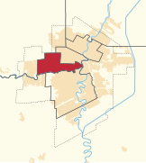 1952 representation order
 1966 representation order
 1987 representation order
 1996 representation order


