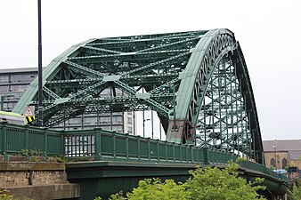
Wearmouth Bridge

Arch bridge

  •  A183   A1018 
  • Motor vehicles
  • UK traffic sign identifying a cycle route 1 
  • Cycles
  • Pedestrians
CrossesRiver Wear Edit this on WikidataLocaleWearside Edit this on WikidataOfficial nameWearmouth Bridge Edit this on WikidataMaintained bySunderland City Council Edit this on WikidataHeritage statusGrade II listed building Edit this on WikidataNext upstreamMonkwearmouth Railway Bridge Edit this on WikidataCharacteristicsDesignThrough arch bridgeMaterialIron Edit this on WikidataTotal length375 ft (114 m) Edit this on WikidataWidth48 ft (15 m) Edit this on WikidataLongest span114 m (374 ft) Edit this on WikidataClearance below105 ft (32 m) Edit this on WikidataNo. of lanes
  • 5
  • 3 northbound
  • 2 southbound
HistoryDesignerMott, Hay and Anderson Edit this on WikidataConstructed bySir William Arrol & Co. Edit this on WikidataConstruction start1927Construction end1929Construction cost£231,943 Edit this on WikidataOpened1929 Edit this on WikidataInaugurated31 October 1929 Edit this on WikidataReplacesWearmouth Bridge Edit this on WikidataLocationMap

Wearmouth Bridge is a through arch bridge across the River Wear in Sunderland, England. It is the final bridge over the river before its mouth with the North Sea.

Original bridge

The original Wearmouth Bridge was designed by Thomas Paine and opened in 1796. In 1805 the bridge was repaired, and between 1857 and 1859 it was reconstructed by Robert Stephenson.

History

To accommodate the growing volume of traffic, construction began on the current bridge in 1927. It was designed by Mott, Hay and Anderson and fabricated by the famous bridge building firm of Sir William Arrol & Co. at their Dalmarnock Ironworks in Glasgow (they also built the famous Forth Rail Bridge and the steel structure of Tower Bridge in London).[1] The new bridge was built around the old one to allow the road to remain open.[2] It was opened on 31 October 1929 by the Duke of York (who would later become King George VI).[3]

The cost of the bridge amounted to £231,943 of which £12,000 was spent on dismantling the old bridge.[3]

The adjoining Monkwearmouth Railway Bridge was built in 1879, and extended the railway south from Monkwearmouth to the centre of Sunderland.[4]

The bridge carries the A183 road between Chester-le-Street and South Shields and the A1018 which was the old route of the A19 until the bypass was built leading to the Tyne Tunnel. It is a Grade II listed building.[5]

Gallery

Images of the Wearmouth Bridge
  • Looking north across the Wearmouth Bridge.
    Looking north across the Wearmouth Bridge.
  • Looking south along the Wearmouth Bridge.
    Looking south along the Wearmouth Bridge.
  • Underneath the Wearmouth Bridge
    Underneath the Wearmouth Bridge

References

  1. ^ 'The Sir William Arrol Collection', Royal Commission on the Ancient and Historical Monuments of Scotland contains many pictures of Wearside Bridge under Construction
  2. ^ "LOCAL STUDIES CENTRE FACT SHEET NUMBER 7: The Wearmouth Bridge". Local Studies Centre collection, Sunderland Public Library Service. Archived from the original on 7 August 2011. Retrieved 30 January 2011.
  3. ^ a b Vickers, Alex. "The second Wearmouth Bridge". National Grid for Learning. Retrieved 24 September 2006.[permanent dead link]
  4. ^ "Historic Structures: Wearmouth Bridge". Sunderland City Council. Archived from the original on 8 May 2005. Retrieved 24 September 2006.
  5. ^ Historic England. "WEARMOUTH BRIDGE (1279911)". National Heritage List for England. Retrieved 19 June 2015.

External links

Wikimedia Commons has media related to Wearmouth Bridge.
  • Wearmouth Bridge over River Wear
  • Image gallery at BBC Wear


Next bridge upstream River Wear Next bridge downstream
Monkwearmouth Bridge
Durham Coast Line & Tyne and Wear Metro
Wearmouth Bridge
Grid reference NZ396574
None
North Sea
  • v
  • t
  • e
Listed buildings in the City of Sunderland
  • v
  • t
  • e
Grade I
Sunderland
Washington
Houghton-le-Spring
  • v
  • t
  • e
Grade II*
Sunderland
Houghton-le-Spring
  • v
  • t
  • e
Grade II
Sunderland
City Centre
Monkwearmouth
and Southwick
Ryhope
and Burdon
Ashbrooke
and Thornholme
  • Bede Tower
  • Sunderland Synagogue
  • Christ Church
  • West Hendon House
  • St John's Church
  • Carlton House
  • Langham Tower
  • Ashburne House
  • The Crofts
  • Gray House
  • St George's House
  • 3–7 Douro Terrace
  • Valebrooke Gardens
  • Westburn House
  • 1–29 Thornhill Terrace
  • 1–15 Grange Crescent
  • 1–9 The Esplanade
  • Burdon House
  • 1–16 St Bede's Terrace
  • 1–24 Park Place East and West
  • Park Road Methodist Church
Hendon
and Grangetown
  • Hendon Gas Works
  • Quayside Exchange
  • St Aidan's Church
  • Trafalgar Square Merchant Seaman's Almshouses
  • St Ignatius Church
  • Tavistock House
  • Sunderland Orphanage
  • 10 Church Street East
  • Salisbury Street Steps
  • Sunderland Cemetery (certain buildings)
  • Former Methodist Manse
  • Bethesda Free Church
  • 17–23 Murton Street
  • 3–19 Ridley Terrace
  • North Dock (walls and mooring posts)
  • Hudson Dock (certain buildings)
  • Sunderland Harbour South Pier
  • Whylam Wharf
  • Bonded Warehouse
Barnes
and Humbledon
Deptford, Millfield
and Pallion
Silksworth
and Tunstall
  • Silksworth Hall
  • Tunstall Lodge
  • Silksworth Cottage
  • Tunstall School
  • Tunstall Hope Lodge
North Hylton
and South Hylton
Fulwell, Roker
and Whitburn Bents
Middle and
East Herrington
Washington
  • Blue House Villa
  • 'F' Pit
  • The Old Hall Smithy
  • Low Barmston Farmhouse
  • Red Hill House
  • Usworth Hall
  • Fatfield House
  • Our Blessed Lady Immaculate Church, Washington
  • Certain buildings in/on: Peareth Hall Road
  • The Avenue
Houghton-le-Spring
Houghton-le-Spring
  • Davenport and Lilburne Almshouses
  • Lilburn House
  • Gilpin House
  • The Villa
  • The Rectory
  • St Michael's Church
  • The Old Mill
  • Laburnum House
  • Houghton Mines Rescue Station
  • High Farm House
  • St Cuthbert's Church
  • Stoneygate Pumping Station
  • Philadelphia Power Station
  • Certain buildings in/on: Nesham Place
  • Front Street, Newbottle
  • Philadelphia Lane
Hetton-le-Hole
  • St Nicholas' Church, Hetton-le-Hole
  • St Nicholas House
  • Easington Lane War Memorial
  • Pithead Baths
  • Smithy
  • Primitive Methodist Church
Newbottle
  • Russell House
  • Newbottle Working Men's Club
  • St Matthew's Church, Newbottle
  • Cellar Hill House
Penshaw
  • All Saints' Church
  • Penshaw House
  • Alice Well
  • Accommodation Arch
  • Boundary Stone
Authority control databases Edit this at Wikidata
International
  • VIAF
National
  • United States
Geographic
  • Structurae