Triboltingen
Municipality in Thurgau, Switzerland

Flag

Coat of arms
Location of Triboltingen

(December 2018)
8273
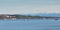
Triboltingen is a small village in the canton of Thurgau in Switzerland, situated on the south shore of the Untersee part of Lake Constance. Since 1975, it is politically part of Ermatingen.
Triboltingen railway station on the Lake Line is served by the S1 of St. Gallen S-Bahn.
47°39′36″N 9°06′40″E / 47.660°N 9.111°E / 47.660; 9.111
- v
- t
- e
Lake Constance (Bodensee)
- Austria
- Germany
- Baden-Württemberg
- Bodenseekreis
- Konstanz
- Bavaria
- Lindau
- Baden-Württemberg
- Switzerland
| Austria | |
|---|---|
| Germany |
|
| Switzerland |
|


- Bodanrück Peninsula
- Dominicans Island
- Entlibühl
- Galgeninsel
- Hoy
- Liebesinsel
- Lindau
- Mainau
- Mettnau Peninsula
- Reichenau
- Triboldingerbohl
- Vogelinsel
- Werd
- Marien Gorge
- Spetzgarter Gorge
- Obersee
- Bay of Bregenz
- Constance Hopper
- Überlinger See
- Rhine Delta
- Untersee
- Gnadensee
- Markelfinger Winkel
- Rheinsee
- Wollmatinger Ried
- Zeller See
| Buildings |
|
|---|---|
| Touristic |
Authority control databases | |
|---|---|
| National |
|
| Other |
|
 | This Thurgau location article is a stub. You can help Wikipedia by expanding it. |
- v
- t
- e


