Spaarnwoude
Village in North Holland, Netherlands

Coat of arms
52°24′N 4°42′E / 52.400°N 4.700°E / 52.400; 4.700
(2021)[1]
2064[1]
Spaarnwoude is a village in the Dutch province of North Holland. It is a part of the municipality of Haarlemmermeer and lies about 5 km (3.1 mi) northeast of Haarlem.
Overview
The village was first mentioned in the first half of the 11th century as Spirnerewalt, and means "forest along the Spaarne river".[3]
The former Dutch Reformed church dates from 1764, but has a tower from the 13th century. It was decommissioned in 1880, but is still used for cultural activities.[4]
North of Spaarnwoude lies the Spaarnwoude recreation area, which is located in the municipalities of Velsen and Haarlemmermeer.
There is a railway station, Haarlem Spaarnwoude, which lies southwest of the village.[5] An IKEA shop is nearby, on the north side. To the east of IKEA is the Veerplas.
Spaarnwoude was home to 443 people in 1840.[4] It was a separate municipality until 1857, when it merged with Haarlemmerliede.[6] The resulting municipality of Haarlemmerliede en Spaarnwoude was later merged with Haarlemmermeer, in 2019.[7]
Gallery
-
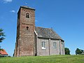 The church of Spaarnwoude
 -
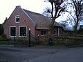 Farm in Spaarnwoude


See also
References
- ^ a b c "Kerncijfers wijken en buurten 2021". Central Bureau of Statistics. Retrieved 30 April 2022.
- ^ "Postcodetool for 2064JZ". Actueel Hoogtebestand Nederland (in Dutch). Het Waterschapshuis. Retrieved 30 April 2022.
- ^ "Spaarnwoude - (geografische naam)". Etymologiebank (in Dutch). Retrieved 30 April 2022.
- ^ a b "Spaarnwoude". Plaatsengids (in Dutch). Retrieved 30 April 2022.
- ^ "halte Haarlem Spaarnwoude". Stationsweb (in Dutch). Retrieved 30 April 2022.
- ^ Ad van der Meer and Onno Boonstra, Repertorium van Nederlandse gemeenten, KNAW, 2011.
- ^ "Gemeentelijke indeling op 1 januari 2019" (in Dutch). CBS. Retrieved 1 January 2019.
External links
- Map of Spaarnwoude.
- v
- t
- e
Populated places in the municipality of Haarlemmermeer
- Abbenes
- Beinsdorp
- Buitenkaag
- Burgerveen
- Cruquius
- Halfweg
- Lijnden
- Lisserbroek
- Rozenburg [nl]
- Spaarndam-Oost [nl]
- Spaarnwoude
- Vijfhuizen
- Weteringbrug
- Zwaanshoek
Business parks and airports
Authority control databases | |
|---|---|
| International |
|
| National |
|
 | This North Holland location article is a stub. You can help Wikipedia by expanding it. |
- v
- t
- e


