San Mateo District, Huarochirí
District in Lima, Peru
San Mateo | |
|---|---|
District | |
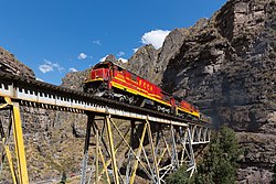 FCCA (Ferrocarril Central Andino) nrs. 1008 and 1009, two GE C30-7, are crossing a steel bridge between Rio Blanco and San Mateo | |
| Country |  Peru Peru |
| Region | Lima |
| Province | Huarochirí |
| Capital | San Mateo |
| Government | |
| • Mayor | Luis Eduardo Rincon Franco (2019–2022) |
| Area | |
| • Total | 425.6 km2 (164.3 sq mi) |
| Elevation | 3,149 m (10,331 ft) |
| Population (2017) | |
| • Total | 4,245 |
| • Density | 10.0/km2 (26/sq mi) |
| Time zone | UTC-5 (PET) |
| UBIGEO | 150722 |
San Mateo District is one of thirty-two districts of the Huarochirí Province, located in the Department of Lima in Peru.[1] It was one of eleven districts that formed the Huarochirí Province after it was created by decree on August 4, 1821, during the Protectorate of San Martín.
Geography
The La Viuda and the Paryaqaqa or Waruchiri mountain ranges traverse the district. Some of the highest mountains of the district are listed below:[2]
- Allqa Allqa
- Chinchiqucha
- Chunta
- Kunkus Yantaq
- Llipina
- Mankan
- Ñuñu
- Paqcha
- Pachanqutu
- Paka
- Qullqayuq
- Quri
- Sarayuq
- Shiraq
- Suyruqucha
- Tata Qayqu
- Uqhu
- Uqsha Wallqa
- Utush Mikhunan
- Wamanripa
- Waskha
- Yana Qaqa
- Yana Yana
- Yuraq Anka (Junín-Lima)
- Yuraq Anka (Lima)
- Yawriq
See also
- Yuraqmayu
References
- ^ (in Spanish) Instituto Nacional de Estadística e Informática. Banco de Información Distrital Archived 2008-04-23 at the Wayback Machine. Retrieved April 11, 2008.
- ^ escale.minedu.gob.pe - UGEL map of the Huarochirí Province (Lima Region)
- v
- t
- e

- Districts of Lima Region
- Peru

- Antioquia
- Callahuanca
- Carampoma
- Chicla
- Cuenca
- Huachupampa
- Huanza
- Huarochirí
- Lahuaytambo
- Langa
- Laraos
- Mariatana
- Matucana
- Ricardo Palma
- San Andrés de Tupicocha
- San Antonio
- San Bartolome
- San Damian
- San Juan de Iris
- San Juan de Tantaranche
- San Lorenzo de Quinti
- San Mateo
- San Mateo de Otao
- San Pedro de Casta
- San Pedro de Huancayre
- Sangallaya
- Santa Cruz de Cocachacra
- Santa Eulalia
- Santiago de Anchucaya
- Santiago de Tuna
- Santo Domingo de los Olleros
- Surco
Authority control databases | |
|---|---|
| International |
|
| National |
|
11°45′31″S 76°18′00″W / 11.7586°S 76.3000°W / -11.7586; -76.3000
 | This Lima Region geography article is a stub. You can help Wikipedia by expanding it. |
- v
- t
- e


