SK postcode area
Postcode area within the United Kingdom
53°22′16″N 2°05′56″W / 53.371°N 2.099°W / 53.371; -2.099
SK
Stockport
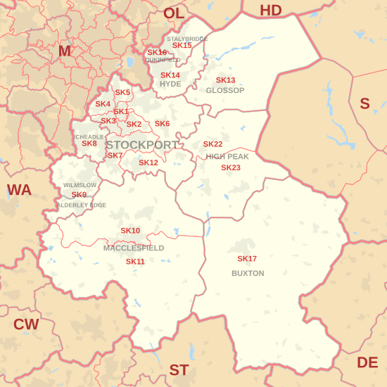
The SK postcode area, also known as the Stockport postcode area,[2] is a group of nineteen postcode districts in England, within eleven post towns. These cover south-east Greater Manchester (including Stockport, Cheadle, Hyde, Stalybridge and Dukinfield), parts of east Cheshire (including Macclesfield, Wilmslow and Alderley Edge), north-west Derbyshire (including Buxton, High Peak and Glossop) and a small part of north Staffordshire.
Coverage
The approximate coverage of the postcode districts:
| Postcode district | Post town | Coverage | Local authority area(s) |
|---|---|---|---|
| SK1 | STOCKPORT | Stockport | Stockport |
| SK2 | STOCKPORT | Stockport, Offerton | Stockport |
| SK3 | STOCKPORT | Stockport, Davenport, Edgeley, Adswood, Bridgehall | Stockport |
| SK4 | STOCKPORT | Stockport, Four Heatons, Heaton Moor | Stockport |
| SK5 | STOCKPORT | Stockport, Brinnington, Reddish | Stockport |
| SK6 | STOCKPORT | Bredbury, Romiley, Woodley, Marple, Marple Bridge, High Lane | Stockport |
| SK7 | STOCKPORT | Bramhall, Hazel Grove, Woodford | Stockport |
| SK8 | CHEADLE | Cheadle, Cheadle Hulme, Gatley, Heald Green | Stockport |
| SK9 | WILMSLOW | Wilmslow, Handforth, Styal | Cheshire East |
| ALDERLEY EDGE | Alderley Edge | ||
| SK10 | MACCLESFIELD | Macclesfield (north), Bollington, Pott Shrigley, Prestbury, Rainow | Cheshire East |
| SK11 | MACCLESFIELD | Macclesfield (south), Sutton, Rushton Spencer | Cheshire East, Staffordshire Moorlands |
| SK12 | STOCKPORT | Disley, Poynton | Cheshire East |
| SK13 | GLOSSOP | Glossop, Hadfield | High Peak |
| SK14 | HYDE | Hyde, Broadbottom, Gee Cross, Hollingworth, Mottram in Longdendale | Tameside |
| SK15 | STALYBRIDGE | Stalybridge, Carrbrook, Heyrod, Matley, Millbrook | Tameside |
| SK16 | DUKINFIELD | Dukinfield | Tameside |
| SK17 | BUXTON | Buxton, Tideswell, Hartington, Longnor, Chelmorton | High Peak, Derbyshire Dales, Staffordshire Moorlands |
| SK22 | HIGH PEAK | Birch Vale, Hayfield, Little Hayfield, New Mills, Rowarth | High Peak |
| SK23 | HIGH PEAK | Buxworth, Chapel-en-le-Frith, Chinley, Combs, Furness Vale, Kettleshulme, Whaley Bridge | Cheshire East, High Peak |
The SK22 and SK23 districts and the HIGH PEAK post town were formed in 1996, out of the SK12 district and the STOCKPORT post town.[3]
Map
KML file (edit • help)
Template:Attached KML/SK postcode area
KML is from Wikidata
See also
References
- ^ "ONS Postcode Directory Version Notes" (ZIP). National Statistics Postcode Products. Office for National Statistics. May 2020. Table 2. Retrieved 19 June 2020. Coordinates from mean of unit postcode points, "Code-Point Open". OS OpenData. Ordnance Survey. February 2012. Retrieved 21 April 2012.
- ^ Royal Mail, Address Management Guide, (2004)
- ^ Royal Mail, Postcode Update 23, July 1996
External links
- Royal Mail's Postcode Address File
- A quick introduction to Royal Mail's Postcode Address File (PAF)
- v
- t
- e
- AB
- AL
- B
- BA
- BB
- BD
- BH
- BL
- BN
- BR
- BS
- BT
- CA
- CB
- CF
- CH
- CM
- CO
- CR
- CT
- CV
- CW
- DA
- DD
- DE
- DG
- DH
- DL
- DN
- DT
- DY
- E
- EC
- EH
- EN
- EX
- FK
- FY
- G
- GL
- GU
- HA
- HD
- HG
- HP
- HR
- HS
- HU
- HX
- IG
- IP
- IV
- KA
- KT
- KW
- KY
- L
- LA
- LD
- LE
- LL
- LN
- LS
- LU
- M
- ME
- MK
- ML
- N
- NE
- NG
- NN
- NP
- NR
- NW
- OL
- OX
- PA
- PE
- PH
- PL
- PO
- PR
- RG
- RH
- RM
- S
- SA
- SE
- SG
- SK
- SL
- SM
- SN
- SO
- SP
- SR
- SS
- ST
- SW
- SY
- TA
- TD
- TF
- TN
- TQ
- TR
- TS
- TW
- UB
- W
- WA
- WC
- WD
- WF
- WN
- WR
- WS
- WV
- YO
- ZE
- Related UK lists: Postcode districts
- Post towns
- Postal counties
- London postal district


