Ramsey Route 17 station
NJ Transit and Metro-North Railroad station
41°04′30″N 74°08′43″W / 41.0750°N 74.1454°W / 41.0750; -74.1454
| Preceding station | Following station | |||
|---|---|---|---|---|
| Mahwah toward Suffern | Main Line | Ramsey toward Hoboken | ||
| Bergen County Line weekdays | ||||
| Preceding station | Following station | |||
| Suffern toward Port Jervis | Port Jervis Line | Secaucus Junction toward Hoboken | ||
| Mahwah (limited service) toward Port Jervis | ||||
Location | |
|---|---|
 |
Ramsey Route 17 station is one of two railroad stations operated by New Jersey Transit in the borough of Ramsey, Bergen County, New Jersey, United States. Named after nearby Route 17, trains at the station are serviced by NJ Transit's Main Line and Bergen County Line, alongside Metro-North Railroad's Port Jervis Line.
History
The current station at Ramsey Route 17 is located next to the Westervelt–Ackerson House on Island Road, which saw service beginning on October 19, 1848, with the opening of the Paterson and Ramapo Railroad. The train went from Paterson to Suffern, where connections were available to the Erie Railroad.[5][6] The station was known as Westervelt's. The current station opened on August 22, 2004.[3]
Station layout
The station has two tracks, each with a high-level side platform. It also has a pedestrian overpass complete with elevators, making it accessible for handicapped persons, and a five-level parking structure which serves as a park and ride.
Gallery
-
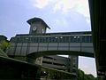 Pedestrian bridge at the Ramsey Route 17 station that is used to cross the railroad tracks
 -
 Interior of the pedestrian bridge
 -
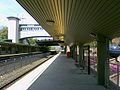 View from westbound platform


References
- ^ "Ramsey Route 17". New Jersey Transit. Retrieved July 11, 2023.
- ^ "Main and Bergen County Line Timetables" (PDF). Newark, New Jersey: New Jersey Transit Rail Operations. November 7, 2010. Archived from the original (PDF) on January 24, 2002. Retrieved November 27, 2010.
- ^ a b "NJ Transit Announces Opening of Ramsey Route 17 Station" (Press release). New Jersey Transit. August 6, 2004.
- ^ Kiefer, Eric (February 21, 2018). "Here Are New Jersey Transit's Most, Least-Used Train Stations". patch.com. Retrieved September 13, 2022.
- ^ "Common Council". The New York Herald. October 17, 1848. p. 1. Retrieved June 20, 2020 – via Newspapers.com.

- ^ "Ramapo and Paterson and Paterson and Hudson River Railroads". The Evening Post. New York, New York. December 7, 1848. p. 4. Retrieved June 20, 2020 – via Newspapers.com.
External links
![]() Media related to Ramsey Route 17 (NJT station) at Wikimedia Commons
Media related to Ramsey Route 17 (NJT station) at Wikimedia Commons
- Station from Route 17 from Google Maps Street View
- v
- t
- e
- Hoboken
- Secaucus Junction
- Harmon Cove
- Rutherford
- Wesmont
- Garfield
- Plauderville
- Broadway
- Radburn
- Glen Rock–Boro Hall
- Ridgewood
- Ho-Ho-Kus
- Waldwick
- Allendale
- Ramsey
- Ramsey Route 17
- Mahwah
- Suffern
| Midtown Direct | |
|---|---|
| Hoboken |
|
- Newark Broad Street
- Roseville Avenue
- Grove Street
- East Orange
- Brick Church
- Orange
- Highland Avenue
- Mountain Station
- South Orange
- Maplewood
- Millburn
- Short Hills
- Summit
- New Providence
- Murray Hill
- Berkeley Heights
- Gillette
- Stirling
- Millington
- Lyons
- Basking Ridge
- Bernardsville
- Far Hills
- Peapack
- Gladstone
| Midtown Direct | |
|---|---|
| Hoboken |
| Boonton Line |
|
|---|
- Harrison
- Newark Broad Street
- Roseville Avenue
- Ampere
- Watsessing Avenue
- Bloomfield
- Glen Ridge
- Bay Street
- Walnut Street
- Watchung Avenue
- Upper Montclair
- Mountain Avenue
- Montclair Heights
- Montclair State University
- Great Notch
- Little Falls
- Wayne Route 23
- Mountain View
- Lincoln Park
- Towaco
- Boonton
- Mountain Lakes
- Denville
- Dover
- Mount Arlington
- Lake Hopatcong
- Netcong
- Mount Olive
- Hackettstown
| Midtown Direct | |
|---|---|
| Hoboken |
|
- Newark Broad Street
- Roseville Avenue
- Grove Street
- East Orange
- Brick Church
- Orange
- Highland Avenue
- Mountain Station
- South Orange
- Maplewood
- Millburn
- Short Hills
- Summit
- Chatham
- Madison
- Convent Station
- Morristown
- Morris Plains
- Mount Tabor
- Denville
- Dover
- Mount Arlington
- Lake Hopatcong
- Netcong
- Mount Olive
- Hackettstown
| Penn Station | |
|---|---|
| Hoboken |
- Newark Penn Station
- Newark Liberty International Airport
- North Elizabeth
- Elizabeth
- Linden
- North Rahway
- Rahway
- Avenel
- Woodbridge
- Perth Amboy
- South Amboy
- Aberdeen–Matawan
- Hazlet
- Middletown
- Red Bank
- Little Silver
- Monmouth Park
- Long Branch
- Elberon
- Allenhurst
- Asbury Park
- Bradley Beach
- Belmar
- Spring Lake
- Manasquan
- Point Pleasant Beach
- Bay Head
| Princeton Branch |
|
|---|
- Hoboken
- Secaucus Junction
- Wood-Ridge
- Teterboro
- Essex Street
- Anderson Street
- Fairmount Avenue
- New Bridge Landing
- River Edge
- Oradell
- Emerson
- Westwood
- Hillsdale
- Woodcliff Lake
- Park Ridge
- Montvale
- (Metro-North Railroad section to Spring Valley) →
| Penn Station | |
|---|---|
| Hoboken |
- Newark Penn Station
- Union
- Roselle Park
- Cranford
- Garwood
- Westfield
- Fanwood
- Netherwood
- Plainfield
- Grant Avenue
- Dunellen
- Bound Brook
- Bridgewater
- Finderne
- Somerville
- Raritan
- North Branch
- White House
- Lebanon
- Annandale
- High Bridge
- Category
- Commons
Italics denote closed stations, stations under construction, and unused line segments.


