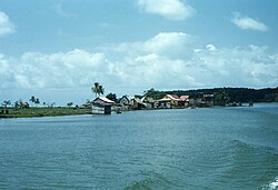
Prinzapolka
Municipality in North Caribbean Coast Autonomous Region, Nicaragua
13°24′N 83°34′W / 13.400°N 83.567°W / 13.400; -83.567 Nicaragua
 (2005)
Prinzapolka (Spanish pronunciation: [pɾinsaˈpolka]) is a Miskito municipality in the North Caribbean Coast Autonomous Region of Nicaragua.
Prinzapolka (sometimes spelled Prinzapolca) is also an important river and river basin in the Caribbean Coast Region of Nicaragua.
Language
Miskito language is dominant in the region, followed by Mayangna and Spanish.
Culture
Since Prinzapolka is a Miskito municipality, Miskito culture is dominant, but there are also Latinos and Mayangnas.[citation needed]
External links
- To view more photos of Prinzapolka taken in the late 1950s, go to this site: https://web.archive.org/web/20100117035333/http://picasaweb.google.com/JimDrebert/SiunaNicaragua1955To1961


- v
- t
- e

Capital: Puerto Cabezas
- Bonanza
- Mulukukú
- Prinzapolka
- Puerto Cabezas
- Rosita
- Siuna
- Waslala
- Waspam

13°24′00″N 83°34′00″W / 13.4°N 83.566667°W / 13.4; -83.566667
 | This Nicaragua location article is a stub. You can help Wikipedia by expanding it. |
- v
- t
- e


