Oudesluis, Schagen
Village in North Holland, Netherlands
52°50′N 4°49′E / 52.833°N 4.817°E / 52.833; 4.817 (2021)[1]
1757[1]
Oudesluis is a village in the Dutch province of North Holland. It is a part of the municipality of Schagen, and lies about 21 km south of Den Helder.
The village was first mentioned around 1660 as Duycker Sluys. The current name means "old sluice". Oude (old) has been added after the Wieringerwaard was poldered to distinguish from Nieuwesluis.[3] Oude Sluis was located on the former Zuiderzee until 1845.[4]
The former Dutch Reformed church was built in 1861, because the old church had been damaged in a storm in 1859. In 1982, the church was sold for ƒ to a foundation and is nowadays used for cultural activities.[4]
In 1867, a railway station opened on the Amsterdam to Den Helder railway line. It closed in 1949.[5]
Gallery
-
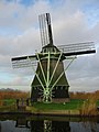 Windmill P
 -
 Dutch Reformed church
 -
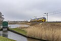 Train passing by


References
- ^ a b c "Kerncijfers wijken en buurten 2021". Central Bureau of Statistics. Retrieved 1 May 2022.
- ^ "Postcodetool for 1757GK". Actueel Hoogtebestand Nederland (in Dutch). Het Waterschapshuis. Retrieved 1 May 2022.
- ^ "Oudesluis - (geografische naam)". Etymologiebank (in Dutch). Retrieved 1 May 2022.
- ^ a b "Oudesluis". Plaatsengids (in Dutch). Retrieved 1 May 2022.
- ^ "stopplaats Oudesluis". Stationsweb (in Dutch). Retrieved 1 May 2022.
- v
- t
- e
Populated places in the municipality of Schagen
- Burgerbrug
- Callantsoog
- Dirkshorn
- Eenigenburg
- Groenveld
- Groote Keeten [nl]
- Krabbendam
- Oudesluis
- Petten
- Schagerbrug
- Sint Maarten
- Sint Maartensbrug
- Sint Maartensvlotbrug
- Stroet
- Tuitjenhorn
- Valkkoog
- Waarland
- Warmenhuizen
- 't Zand
 | This North Holland location article is a stub. You can help Wikipedia by expanding it. |
- v
- t
- e


