Map of Vindelfjällen Nature Reserve with Norra Storfjället along the western border.
Norra Storfjället is a minor sub-range of the Scandinavian Mountains, located in the county of Västerbotten, in Lapland, Sweden. It is, for the most part, located within Vindelfjällen Nature Reserve. It reaches a maximum height of 1,768 m (5,801 ft) at the peak known as Norra Sytertoppen.[1] Other peaks include Måskostjakke (1,690 m (5,540 ft)) and Södra Sytertoppen (1,685 m (5,528 ft)).[1] It is divided approximately in half by a deep valley, the valley of Syterskalet – Viterskalet. This U-shaped valley, similar to Lapporten in northern Lapland, is one of the natural landmarks of the reserve. A ski resort is located at Hemavan in the southwest of the area.
Gallery
Södra Sytertoppen in the foreground and Norra Sytertoppen in the background.
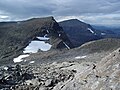
Norra Sytertoppen, the highest point of the Norra Storfjället.


 Södra Sytertoppen in the foreground and Norra Sytertoppen in the background.
 Norra Sytertoppen, the highest point of the Norra Storfjället.
 View of Norra Storfjället from a distance


