Neve Michael
Place in Jerusalem, Israel
Neve Michael נווה מיכאל | |
|---|---|
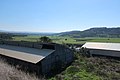
 Neve Michael from a hill overlooking the Elah Valley | |
| 31°40′22″N 35°0′22″E / 31.67278°N 35.00611°E / 31.67278; 35.00611 | |
| Country | Israel |
| District | Jerusalem |
| Council | Mateh Yehuda |
| Affiliation | Hitahdut HaIkarim |
| Founded | 1958 |
| Founded by | Kurdish Jews |
| Population (2022)[1] | 883 |
Neve Michael (Hebrew: נְוֵה מִיכָאֵל, lit. 'Michael's Haven')[2] also known as Roglit, is a moshav in central Israel. Located in the Adullam region and built upon an eminence in the far south-east end of the Elah Valley, it falls under the jurisdiction of Mateh Yehuda Regional Council. In 2022 it had a population of 883.[1]
History
The village was established on 29 July 1958 (12 Av 5718 anno mundi) by Kurdish immigrants from Iran on farm land that had belonged to the depopulated Palestinian village of Bayt Nattif.[3] The place had formerly been known as Khirbet Jurfah,[4] where archaeological finds ranged from the early Hellenistic period to the Umayyad period with evidence of a Jewish settlement in the first century CE.[5]
The newly restructured Jewish National Fund (JNF), working in concert with the Hitahdut HaIkarim agricultural organisation, settled new immigrants on the site in 1958, giving to the place the name Roglit (Hebrew: רוֹגְלִית), meaning "tiller [of the grapevine]". The new immigrants were initially employed as laborers for JNF land reclamation. Afterwards, the village economy was based on agriculture (citrus fruit) and poultry, which phased out in the late 1980s. A newer regional community center built alongside it was given the name Neve Michael, in memory of American philanthropist, Michael M. Weiss, who was a donor to the JNF.[6]
The newer section had a regional elementary school which catered to children from the surrounding communities of Roglit, Aderet and Aviezer, but closed its doors in the early 1980s.[citation needed] Today, the grounds of the old school serve as a home for the mentally and physically disabled. When the new settlement of Neve Michael failed to attract new residents, the settlement of Neve Michael was merged with Roglit in 1983.
A new Israel Border Police outpost was also built in Neve Michael, which was later abandoned in 1962. The founders were joined by immigrants from North Africa, mainly Morocco.[7] In 2005 the village started an expansion plan attracting many younger families to the moshav. The moshav has a mixed population with people of different ages, ethnic background and Jewish religious observance.[citation needed]
Within relatively short driving distances from the moshav are the ruins known as Adullam and Hurvat Itri.

Gallery
-
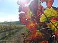 Vineyard at Neve Michael
 -
 View of Valley from the Moshav
 -
 Sunrise over the Elah Valley
 -
 Houses in Neve Michael
 -
 Terebinth tree (Pistacia atlantica) in the Elah valley, on south side of Neve Michael
 -
 Beneath the shady boughs of a terebinth
 -
 Terebinth (Pistacia atlantica) growing in the Elah Valley
 -
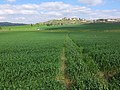 Wheat fields in the Valley of Elah
 -
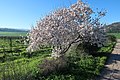 Almond tree with blossoming flowers
 -
 The ruined structure of an ancient house, in Kh. Jubeil Naqqar, near Neve Michael
 -
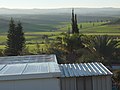
 The Community Center in Moshav Neve Michael
 -
 Neve Michael looking out over Wadi Sur
 -
 Moshav as seen from eastern mountain
 -
 The eminence on which the village sits
 -
 Wheat fields in valley
 -
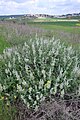 Dominican sage (Salvia dominica) and Neve Michael in background


References
Wikimedia Commons has media related to Neve Michael.
- ^ a b "Regional Statistics". Israel Central Bureau of Statistics. Retrieved 21 March 2024.
- ^ English translation follows the Judeo-Arabic translation of the Hebrew "neve" = מאוא (مأوى), in Jeremiah 50:7, published in Yosef Tobi's Poetry, Judeo-Arabic Literature and the Geniza, Tel-Aviv 2006, p. 59 (Hebrew)
- ^ Khalidi, Walid (1992). All That Remains: The Palestinian Villages Occupied and Depopulated by Israel in 1948. Washington D.C.: Institute for Palestine Studies. p. 212. ISBN 0-88728-224-5.
- ^ In the Survey of Western Palestine (Arabic and English Name Lists), London 1881, p. 307, E.H. Palmer describes the site Khŭrbet Jurfa as "the ruin of the perpendicular bank (cut out by the torrent in the débris of a valley)." If its name is of Aramaic origins, according to Payne-Smith's lexicon of the Aramaic/Syriac language, the name "Jurfa" (ܓܘܪܦܐ), being a derivative of Greek: γορϕίον, has the connotation of "a cutting or slip of the olive-tree; a hollow in a tree." See Payne Smith, J. (1903). A compendious Syriac Dictionary: founded upon the Thesaurus Syriacus of R. Payne Smith (in Syriac and English). Oxford: Clarendon Press. OCLC 251355373., p. 66.
- ^ Avner, Rina (2006). "Rogelit". Hadashot Arkheologiyot: Excavations and Surveys in Israel. 118. Israel Antiquities Authority.
- ^ Stone Monument in Neve Michael, in memory of Michael M. Weiss; In recognition of Michael M. Weiss
- ^ About Neve Michael Homee (in Hebrew)
External links
- Rogelit in Antiquity Archaeological Survey of Israel
- v
- t
- e
- Aderet
- Agur
- Aminadav
- Aviezer
- Bar Giora
- Beit Zayit
- Beit Meir
- Beit Nekofa
- Bekoa
- Eshtaol
- Even Sapir
- Gefen
- Giv'at Ye'arim
- Givat Yeshayahu
- Kfar Uria
- Ksalon
- Luzit
- Mevo Beitar
- Mata
- Mahsia
- Mesilat Zion
- Naham
- Nehusha
- Nes Harim
- Neve Ilan
- Neve Michael
- Ora
- Ramat Raziel
- Sdot Micha
- Sho'eva
- Shoresh
- Ta'oz
- Tal Shahar
- Tarum
- Tirosh
- Tzafririm
- Tzelafon
- Yad HaShmona
- Yish'i
- Zanoah
- Zekharia
Authority control databases | |
|---|---|
| International |
|
| National |
|


