National Register of Historic Places listings in Shiawassee County, Michigan
The following is a list of Registered Historic Places in Shiawassee County, Michigan.
This National Park Service list is complete through NPS recent listings posted June 14, 2024.[1]
Map all coordinates using OpenStreetMap
Download coordinates as:
- KML
- GPX (all coordinates)
- GPX (primary coordinates)
- GPX (secondary coordinates)
| [2] | Name on the Register[3] | Image | Date listed[4] | Location | City or town | Description |
|---|---|---|---|---|---|---|
| 1 | Nathan Ayres House |  | November 4, 1980 (#80001891) | 604 N. Water St. 43°00′11″N 84°10′23″W / 43.003056°N 84.173056°W / 43.003056; -84.173056 (Nathan Ayres House) | Owosso | |
| 2 | Byron Historic Commercial District |  | September 13, 1984 (#84001848) | Roughly Saginaw St. from Maple to Water Sts. 42°49′20″N 83°56′39″W / 42.822222°N 83.944167°W / 42.822222; -83.944167 (Byron Historic Commercial District) | Byron | |
| 3 | Charles H. Calkins House |  | March 29, 1978 (#78001511) | 127 E. 1st St. 42°49′27″N 84°13′05″W / 42.824167°N 84.218056°W / 42.824167; -84.218056 (Charles H. Calkins House) | Perry | |
| 4 | Leigh Christian House |  | November 4, 1980 (#80001892) | 622 N. Ball St. 43°00′13″N 84°10′19″W / 43.003611°N 84.171944°W / 43.003611; -84.171944 (Leigh Christian House) | Owosso | |
| 5 | Christian-Ellis House |  | November 4, 1980 (#80001893) | 600 N. Water St. 43°00′10″N 84°10′23″W / 43.002778°N 84.173056°W / 43.002778; -84.173056 (Christian-Ellis House) | Owosso | |
| 6 | Hezekiah W. and Sarah E. Fishell Cobb House |  | April 11, 1997 (#97000281) | 115 W. 2nd St. 42°49′29″N 84°13′12″W / 42.824722°N 84.22°W / 42.824722; -84.22 (Hezekiah W. and Sarah E. Fishell Cobb House) | Perry | |
| 7 | Elias Comstock Cabin |  | November 4, 1980 (#80001894) | Curwood Castle Dr., and John St. 42°59′57″N 84°10′32″W / 42.999167°N 84.175556°W / 42.999167; -84.175556 (Elias Comstock Cabin) | Owosso | |
| 8 | Corunna High School |  | March 13, 2017 (#100000748) | 106 S. Shiawassee St. 42°58′46″N 84°07′07″W / 42.979338°N 84.118707°W / 42.979338; -84.118707 (Corunna High School) | Corunna | |
| 9 | Curwood Castle |  | September 3, 1971 (#71000420) | 224 John St. 42°59′58″N 84°10′31″W / 42.999444°N 84.175278°W / 42.999444; -84.175278 (Curwood Castle) | Owosso | |
| 10 | Duff Building |  | January 31, 1985 (#85000168) | 118 W. Exchange St 42°59′56″N 84°10′18″W / 42.998817°N 84.171601°W / 42.998817; -84.171601 (Duff Building) | Owosso | |
| 11 | Durand High School |  | March 17, 2009 (#09000130) | 100 West Sycamore Street 42°54′55″N 83°59′11″W / 42.915278°N 83.986389°W / 42.915278; -83.986389 (Durand High School) | Durand | |
| 12 | Frederick Frieseke Birthplace and Boyhood Home |  | November 4, 1980 (#80001895) | 654 N. Water St. 43°00′15″N 84°10′23″W / 43.004167°N 84.173056°W / 43.004167; -84.173056 (Frederick Frieseke Birthplace and Boyhood Home) | Owosso | |
| 13 | Julius Frieseke House |  | April 5, 1990 (#90000574) | 529 Corunna Ave. 42°59′30″N 84°09′51″W / 42.991667°N 84.164167°W / 42.991667; -84.164167 (Julius Frieseke House) | Owosso | |
| 14 | Amos Gould House |  | November 4, 1980 (#80001896) | 115 W. King St. 43°00′16″N 84°10′18″W / 43.004444°N 84.171667°W / 43.004444; -84.171667 (Amos Gould House) | Owosso | |
| 15 | Daniel Gould House |  | November 4, 1980 (#80001897) | 509 E. Main St. 42°59′52″N 84°09′51″W / 42.9977°N 84.1643°W / 42.9977; -84.1643 (Daniel Gould House) | Owosso | Building no longer exists. |
| 16 | Ebenezer Gould House |  | November 4, 1980 (#80001898) | orig. 603 W. Main St. now: 42°59′01″N 84°07′38″W / 42.983686°N 84.1271645°W / 42.983686; -84.1271645 (Ebenezer Gould House) | Owosso | Building relocated to historic/museum village in nearby Corunna. |
| 17 | Grand Trunk Railway Station |  | May 6, 1971 (#71000419) | 200 Railroad St. 42°54′33″N 83°58′57″W / 42.909167°N 83.9825°W / 42.909167; -83.9825 (Grand Trunk Railway Station) | Durand | |
| 18 | Grow Block |  | January 31, 1985 (#85000169) | 120-122 W. Exchange St. 42°59′56″N 84°10′18″W / 42.998889°N 84.171667°W / 42.998889; -84.171667 (Grow Block) | Owosso | |
| 19 | William Horton Farmhouse |  | April 10, 1986 (#86000711) | 1647 W. Miller Rd. 42°51′49″N 84°11′52″W / 42.863611°N 84.197778°W / 42.863611; -84.197778 (William Horton Farmhouse) | Morrice | |
| 20 | House at 314 W. King St. |  | November 4, 1980 (#80001899) | 314 W. King St. 43°00′18″N 84°10′26″W / 43.005°N 84.173889°W / 43.005; -84.173889 (House at 314 W. King St.) | Owosso | Replaced by a newer house at the same address. |
| 21 | John N. Ingersoll House |  | May 9, 1980 (#80001890) | 570 W. Corunna Ave. 42°58′57″N 84°07′35″W / 42.9825°N 84.126389°W / 42.9825; -84.126389 (John N. Ingersoll House) | Corunna | |
| 22 | Eugene Jacobs House |  | November 4, 1980 (#80004553) | 220 W. King St. 43°00′18″N 84°10′23″W / 43.005°N 84.173056°W / 43.005; -84.173056 (Eugene Jacobs House) | Owosso | |
| 23 | Lincoln School |  | August 8, 2016 (#16000510) | 120 Michigan Ave. 42°59′50″N 84°10′29″W / 42.997182°N 84.174849°W / 42.997182; -84.174849 (Lincoln School) | Owosso | |
| 24 | Martin Road Bridge |  | July 12, 1991 (#91000876) | Martin Rd. across the Shiawassee River, Caledonia Township 42°58′08″N 84°03′21″W / 42.968889°N 84.055833°W / 42.968889; -84.055833 (Martin Road Bridge) | Corunna | In 2016, the bridge was disassembled and removed by Bach Steel. Renovation is underway, and it will be re-assembled at the Auburn Heights Preserve in Yorklyn, Delaware.[5] |
| 25 | Mason Street Historic Residential District |  | November 4, 1980 (#80001900) | Roughly bounded by Laverock Alley, Dewey, Hickory and Exchange Sts. 42°59′57″N 84°09′54″W / 42.999167°N 84.165°W / 42.999167; -84.165 (Mason Street Historic Residential District) | Owosso | |
| 26 | Colin McCormick House | 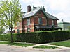 | November 4, 1980 (#80001901) | 222 E. Exchange St. 42°59′53″N 84°10′06″W / 42.998056°N 84.168333°W / 42.998056; -84.168333 (Colin McCormick House) | Owosso | |
| 27 | Michigan Avenue-Genesee Street Historic Residential District |  | November 4, 1980 (#80001902) | Roughly bounded by Michigan Ave.; Shiawassee, Cass and Clinton Sts. 42°59′43″N 84°10′32″W / 42.995278°N 84.175556°W / 42.995278; -84.175556 (Michigan Avenue-Genesee Street Historic Residential District) | Owosso | |
| 28 | Selden Miner House | 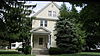 | November 4, 1980 (#80001903) | 418 W. King St. 43°00′18″N 84°10′32″W / 43.005°N 84.175556°W / 43.005; -84.175556 (Selden Miner House) | Owosso | |
| 29 | Old Miller Hospital |  | November 4, 1980 (#80001904) | 121 Michigan Ave. 42°59′48″N 84°10′29″W / 42.996667°N 84.174722°W / 42.996667; -84.174722 (Old Miller Hospital) | Owosso | |
| 30 | Oliver Street Historic District |  | November 4, 1980 (#80001905) | Oliver St. between 3rd and Oak Sts., Williams and Goodhue Sts. 43°00′06″N 84°10′24″W / 43.001667°N 84.173333°W / 43.001667; -84.173333 (Oliver Street Historic District) | Owosso | |
| 31 | Sylvester Opdyke House | 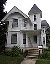 | November 4, 1980 (#80001906) | 655 N. Pine St. 43°00′16″N 84°10′33″W / 43.004444°N 84.175833°W / 43.004444; -84.175833 (Sylvester Opdyke House) | Owosso | |
| 32 | Owosso Downtown Historic District |  | April 7, 2014 (#14000126) | Roughly bounded by Shiawassee R., Comstock, Water, Park and Mason Sts. 42°59′53″N 84°10′14″W / 42.998140°N 84.170655°W / 42.998140; -84.170655 (Owosso Downtown Historic District) | Owosso | |
| 33 | Albert Palmer House |  | November 4, 1980 (#80001907) | 528-530 River St. 42°59′58″N 84°10′43″W / 42.999444°N 84.178611°W / 42.999444; -84.178611 (Albert Palmer House) | Owosso | |
| 34 | George Pardee House |  | November 4, 1980 (#80001908) | 603 N. Ball St. 43°00′10″N 84°10′20″W / 43.002778°N 84.172222°W / 43.002778; -84.172222 (George Pardee House) | Owosso | |
| 35 | Pere Marquette Railway Steam Locomotive No. 1225 |  | July 31, 1994 (#94000744) | 600 S. Oakwood St. 42°59′35″N 84°09′53″W / 42.993056°N 84.164722°W / 42.993056; -84.164722 (Pere Marquette Railway Steam Locomotive No. 1225) | Owosso | |
| 36 | George Perrigo House |  | November 4, 1980 (#80001909) | 213 N. Cedar St. 42°59′56″N 84°10′55″W / 42.998889°N 84.181944°W / 42.998889; -84.181944 (George Perrigo House) | Owosso | |
| 37 | Shiawassee County Courthouse | 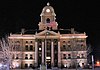 | November 12, 1982 (#82000546) | Shiawassee St. 42°58′53″N 84°07′02″W / 42.981389°N 84.117222°W / 42.981389; -84.117222 (Shiawassee County Courthouse) | Corunna | see Claire Allen for more info |
| 38 | Edwin Todd House |  | November 4, 1980 (#80001910) | 520 N. Adams St. 43°00′10″N 84°10′28″W / 43.002778°N 84.174444°W / 43.002778; -84.174444 (Edwin Todd House) | Owosso | |
| 39 | West Town Historic Commercial and Industrial District | 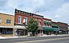 | November 4, 1980 (#80001911) | Main St. 42°59′55″N 84°11′02″W / 42.998611°N 84.183889°W / 42.998611; -84.183889 (West Town Historic Commercial and Industrial District) | Owosso | |
| 40 | Alfred Williams House |  | November 4, 1980 (#80001912) | 611 N. Ball St. 43°00′12″N 84°10′20″W / 43.003333°N 84.172222°W / 43.003333; -84.172222 (Alfred Williams House) | Owosso | |
| 41 | Benjamin Williams House |  | November 4, 1980 (#80001913) | 628 N. Ball St. 43°00′14″N 84°10′19″W / 43.003889°N 84.171944°W / 43.003889; -84.171944 (Benjamin Williams House) | Owosso | |
| 42 | Williams-Cole House |  | December 4, 1986 (#86003418) | 6810 Newburg Rd. 42°54′35″N 84°01′49″W / 42.909722°N 84.030278°W / 42.909722; -84.030278 (Williams-Cole House) | Durand | |
| 43 | Lee Woodard and Sons Building |  | November 4, 1980 (#80001914) | 306 S. Elm St. 42°59′42″N 84°10′42″W / 42.995°N 84.178333°W / 42.995; -84.178333 (Lee Woodard and Sons Building) | Owosso | |
| 44 | Lyman Woodard Company Workers' Housing |  | November 4, 1980 (#80001916) | 601 Clinton St. 42°59′47″N 84°10′43″W / 42.996389°N 84.178611°W / 42.996389; -84.178611 (Lyman Woodard Company Workers' Housing) | Owosso | |
| 45 | Lyman Woodard Furniture and Casket Company Building |  | November 4, 1980 (#80001915) | 216-222 Elm St. 42°59′44″N 84°10′43″W / 42.995556°N 84.178611°W / 42.995556; -84.178611 (Lyman Woodard Furniture and Casket Company Building) | Owosso |
See also
Wikimedia Commons has media related to National Register of Historic Places in Shiawassee County, Michigan.
- List of Michigan State Historic Sites in Shiawassee County, Michigan
- List of National Historic Landmarks in Michigan
- National Register of Historic Places listings in Michigan
- Listings in neighboring counties: Clinton, Genesee, Gratiot, Ingham, Livingston, Saginaw
References
- ^ National Park Service, United States Department of the Interior, "National Register of Historic Places: Weekly List Actions", retrieved June 14, 2024.
- ^ Numbers represent an alphabetical ordering by significant words. Various colorings, defined here, differentiate National Historic Landmarks and historic districts from other NRHP buildings, structures, sites or objects.
- ^ "National Register Information System". National Register of Historic Places. National Park Service. April 24, 2008.
- ^ The eight-digit number below each date is the number assigned to each location in the National Register Information System database, which can be viewed by clicking the number.
- ^ "Martin Road Bridge". Historic Bridges.org. Retrieved November 30, 2018.
- v
- t
- e
- Alcona
- Alger
- Allegan
- Alpena
- Antrim
- Arenac
- Baraga
- Barry
- Bay
- Benzie
- Berrien
- Branch
- Calhoun
- Cass
- Charlevoix
- Cheboygan
- Chippewa
- Clare
- Clinton
- Crawford
- Delta
- Dickinson
- Eaton
- Emmet
- Genesee
- Gladwin
- Gogebic
- Grand Traverse
- Gratiot
- Hillsdale
- Houghton
- Huron
- Ingham
- Ionia
- Iosco
- Iron
- Isabella
- Jackson
- Kalamazoo
- Kalkaska
- Kent
- Keweenaw
- Lake
- Lapeer
- Leelanau
- Lenawee
- Livingston
- Luce
- Mackinac
- Macomb
- Manistee
- Marquette
- Mason
- Mecosta
- Menominee
- Midland
- Missaukee
- Monroe
- Montcalm
- Montmorency
- Muskegon
- Newaygo
- Oakland
- Oceana
- Ogemaw
- Ontonagon
- Osceola
- Oscoda
- Otsego
- Ottawa
- Presque Isle
- Roscommon
- Saginaw
- Sanilac
- Schoolcraft
- Shiawassee
- St. Clair
- St. Joseph
- Tuscola
- Van Buren
- Washtenaw
- Wayne
- Wexford

- Bridges
- Historic districts
- Houses
- Michigan State Historic Sites (listings)
- National Historic Landmarks
- Properties of religious function
- Railway stations
| |
|---|---|
| Topics | |
| Lists by state |
|
| Lists by insular areas | |
| Lists by associated state | |
| Other areas | |
| Related | |
| |


