National Register of Historic Places listings in Orange County, North Carolina
Map all coordinates using OpenStreetMap
Download coordinates as:
- KML
- GPX (all coordinates)
- GPX (primary coordinates)
- GPX (secondary coordinates)

This list includes properties and districts listed on the National Register of Historic Places in Orange County, North Carolina. Click the "Map of all coordinates" link to the right to view an online map of all properties and districts with latitude and longitude coordinates in the table below.[1]
Current listings
This National Park Service list is complete through NPS recent listings posted June 7, 2024.[2]
| [3] | Name on the Register[4] | Image | Date listed[5] | Location | City or town | Description |
|---|---|---|---|---|---|---|
| 1 | Alberta Mill Complex |  | January 19, 1976 (#76001332) | NE corner Weaver and N. Greensboro Sts. 35°54′41″N 79°04′17″W / 35.911389°N 79.071389°W / 35.911389; -79.071389 (Alberta Mill Complex) | Carrboro | |
| 2 | Ayr Mount | 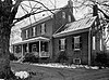 | August 26, 1971 (#71000606) | St. Mary's Rd. 36°04′37″N 79°05′30″W / 36.076944°N 79.091667°W / 36.076944; -79.091667 (Ayr Mount) | Hillsborough | |
| 3 | Bellevue Manufacturing Company | 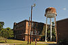 | August 28, 2003 (#03000858) | Nash St. and Eno St. 36°04′23″N 79°06′41″W / 36.073056°N 79.111389°W / 36.073056; -79.111389 (Bellevue Manufacturing Company) | Hillsborough | |
| 4 | Beta Theta Pi Fraternity House | 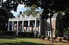 | April 20, 2005 (#05000325) | 114 South Columbia St. 35°54′49″N 79°03′20″W / 35.913611°N 79.055556°W / 35.913611; -79.055556 (Beta Theta Pi Fraternity House) | Chapel Hill | |
| 5 | Bingham School | 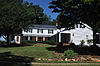 | January 18, 1978 (#78001969) | NC 54 and SR 1007 35°57′13″N 79°15′16″W / 35.953611°N 79.254444°W / 35.953611; -79.254444 (Bingham School) | Oaks | |
| 6 | Burwell School |  | September 15, 1970 (#70000465) | N. Churton St. 36°04′45″N 79°06′00″W / 36.079167°N 79.1°W / 36.079167; -79.1 (Burwell School) | Hillsborough | |
| 7 | Cabe-Pratt-Harris House | Upload image | April 22, 1999 (#99000481) | NC 1567. 0.9 miles N. of Eno River Bridge 36°03′29″N 79°00′28″W / 36.058056°N 79.007778°W / 36.058056; -79.007778 (Cabe-Pratt-Harris House) | Hillsborough | |
| 8 | Carolina Inn |  | August 6, 1999 (#99000867) | 211 Pittsboro St. 35°54′36″N 79°03′18″W / 35.91°N 79.055°W / 35.91; -79.055 (Carolina Inn) | Chapel Hill | |
| 9 | Carrboro Commercial Historic District |  | June 20, 1985 (#85001339) | 100 Blk. of E. Main St. between Greensboro Rd. & Roberson St. 35°54′37″N 79°04′18″W / 35.910278°N 79.071667°W / 35.910278; -79.071667 (Carrboro Commercial Historic District) | Carrboro | |
| 10 | Cedar Grove Rural Crossroads Historic District |  | April 23, 1998 (#98000389) | Roughly along Carr Store Rd. and Efland-Cedar Grove Rd. 36°10′12″N 79°10′11″W / 36.17°N 79.169722°W / 36.17; -79.169722 (Cedar Grove Rural Crossroads Historic District) | Cedar Grove | |
| 11 | Cedar Grove School | Upload image | April 23, 2020 (#100005201) | 5800 NC 86 North 36°10′44″N 79°08′10″W / 36.1789°N 79.1361°W / 36.1789; -79.1361 (Cedar Grove School) | Cedar Grove | |
| 12 | Chapel Hill Historic District |  | December 16, 1971 (#71000604) | Battle Park, E. Franklin and E. Rosemary Sts. residences, and central campus of University of North Carolina; also roughly bounded by Carolina Ave., North, Cameron & Columbia Sts. 35°54′45″N 79°03′08″W / 35.9125°N 79.052222°W / 35.9125; -79.052222 (Chapel Hill Historic District) | Chapel Hill | Second set of addresses represents a boundary increase, 2015 |
| 13 | Chapel Hill Town Hall | 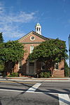 | March 20, 1990 (#90000364) | Rosemary and Columbia Sts. 35°54′51″N 79°03′25″W / 35.914167°N 79.056944°W / 35.914167; -79.056944 (Chapel Hill Town Hall) | Chapel Hill | |
| 14 | Chapel of the Cross |  | February 1, 1972 (#72000980) | 304 E. Franklin St. 35°54′58″N 79°02′39″W / 35.916111°N 79.044167°W / 35.916111; -79.044167 (Chapel of the Cross) | Chapel Hill | |
| 15 | Commandant's House | 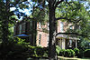 | November 9, 1972 (#72000981) | Barracks Rd. 36°04′19″N 79°07′22″W / 36.071944°N 79.122778°W / 36.071944; -79.122778 (Commandant's House) | Hillsborough | |
| 16 | Eagle Lodge | 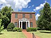 | April 16, 1971 (#71000607) | 142 W. King St. 36°04′31″N 79°05′59″W / 36.075278°N 79.099722°W / 36.075278; -79.099722 (Eagle Lodge) | Hillsborough | Masonic Lodge |
| 17 | Eno Cotton Mill |  | September 1, 2011 (#11000622) | 437 Dimmocks Mill Rd. 36°04′14″N 79°06′48″W / 36.070556°N 79.113333°W / 36.070556; -79.113333 (Eno Cotton Mill) | Hillsborough | |
| 18 | Faucett Mill and House | 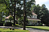 | August 4, 1988 (#88001175) | Faucette Mill Rd. on the E side of Eno River 36°06′04″N 79°08′25″W / 36.101111°N 79.140278°W / 36.101111; -79.140278 (Faucett Mill and House) | Hillsborough | |
| 19 | David Faucette House |  | November 22, 1999 (#99001391) | 1830 Hall's Mill Rd. 36°07′21″N 79°09′20″W / 36.1225°N 79.155556°W / 36.1225; -79.155556 (David Faucette House) | Efland | |
| 20 | Gimghoul Neighborhood Historic District | 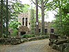 | August 5, 1993 (#93000807) | Roughly bounded by Gimghoul Rd., Ridge Ln., and Gladon Dr. 35°54′47″N 79°02′24″W / 35.913056°N 79.04°W / 35.913056; -79.04 (Gimghoul Neighborhood Historic District) | Chapel Hill | |
| 21 | Hazel-Nash House | 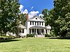 | March 31, 1971 (#71000608) | 116 W. Queen St. 36°04′44″N 79°06′04″W / 36.078889°N 79.101111°W / 36.078889; -79.101111 (Hazel-Nash House) | Hillsborough | |
| 22 | Heartsease | 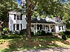 | April 11, 1973 (#73001362) | 115 E. Queen St. 36°04′44″N 79°06′07″W / 36.078889°N 79.101944°W / 36.078889; -79.101944 (Heartsease) | Hillsborough | |
| 23 | Hillsborough Historic District | 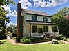 | October 15, 1973 (#73001363) | Roughly bounded by N. Nash and W. Corbin Sts., Highland Loop Rd., and Eno River 36°04′25″N 79°05′44″W / 36.073611°N 79.095556°W / 36.073611; -79.095556 (Hillsborough Historic District) | Hillsborough | |
| 24 | Alexander Hogan Plantation |  | March 4, 1996 (#96000186) | Rogers Road and Eubanks Road Coordinates missing | Chapel Hill | |
| 25 | Thomas and Mary Hogan House |  | January 26, 2001 (#01000016) | 9118 Hillsborough Rd. 35°56′27″N 79°06′15″W / 35.940833°N 79.104167°W / 35.940833; -79.104167 (Thomas and Mary Hogan House) | Carrboro | |
| 26 | Holden-Roberts Farm |  | May 2, 2002 (#02000436) | NC 1002, 1 miles E of NC 1538 36°06′36″N 79°02′11″W / 36.11°N 79.036389°W / 36.11; -79.036389 (Holden-Roberts Farm) | Hillsborough | |
| 27 | Jacob Jackson Farm |  | March 17, 1994 (#94000184) | NC 1002, 0.4 miles W of NC 1538 36°05′35″N 79°03′37″W / 36.093056°N 79.060278°W / 36.093056; -79.060278 (Jacob Jackson Farm) | Hillsborough | |
| 28 | Dr. Arch Jordan House |  | August 6, 1998 (#98000995) | 7015 NC 57 36°11′06″N 79°01′08″W / 36.185°N 79.018889°W / 36.185; -79.018889 (Dr. Arch Jordan House) | Caldwell | |
| 29 | Thomas F. Lloyd Historic District |  | August 14, 1986 (#86001625) | Roughly bounded by E. Carr St., Maple Ave., and S. Greensboro St. 35°54′26″N 79°04′17″W / 35.907222°N 79.071389°W / 35.907222; -79.071389 (Thomas F. Lloyd Historic District) | Carrboro | |
| 30 | Montrose |  | October 28, 2001 (#01001187) | 320 St. Mary's Rd. 36°04′41″N 79°08′36″W / 36.078056°N 79.143333°W / 36.078056; -79.143333 (Montrose) | Hillsborough | |
| 31 | Moorefields |  | April 25, 1972 (#72000982) | N of jct. of SR 1134 and 1135 36°03′07″N 79°08′43″W / 36.051944°N 79.145278°W / 36.051944; -79.145278 (Moorefields) | Hillsborough | |
| 32 | Murphey School |  | August 20, 2009 (#09000637) | 3729 Murphy School Rd. 36°01′44″N 79°00′52″W / 36.028908°N 79.014314°W / 36.028908; -79.014314 (Murphey School) | Hillsborough | |
| 33 | Nash Law Office |  | September 28, 1971 (#71000609) | 143 W. Margaret Lane 36°04′27″N 79°06′05″W / 36.074167°N 79.101389°W / 36.074167; -79.101389 (Nash Law Office) | Hillsborough | |
| 34 | Nash-Hooper House |  | November 11, 1971 (#71000610) | 118 W. Tryon St. 36°04′03″N 79°06′03″W / 36.0675°N 79.100833°W / 36.0675; -79.100833 (Nash-Hooper House) | Hillsborough | |
| 35 | Arthur C. and Mary S.A. Nash House |  | October 26, 2017 (#100001633) | 124 S. Boundary St. 35°54′50″N 79°02′43″W / 35.913975°N 79.045392°W / 35.913975; -79.045392 (Arthur C. and Mary S.A. Nash House) | Chapel Hill | |
| 36 | Navy Reserve Officers Training Corps (NROTC) Naval Armory at UNC-Chapel Hill |  | February 7, 2024 (#100009948) | 221 South Columbia St. 35°54′32″N 79°03′11″W / 35.9090°N 79.0530°W / 35.9090; -79.0530 (Navy Reserve Officers Training Corps (NROTC) Naval Armory at UNC-Chapel Hill) | Chapel Hill | |
| 37 | Jeter and Ethel Neville House |  | August 1, 2023 (#100007247) | 107 Cobb St. 35°54′42″N 79°04′06″W / 35.9117°N 79.0682°W / 35.9117; -79.0682 (Jeter and Ethel Neville House) | Carrboro | |
| 38 | North Carolina Industrial Home for Colored Girls | Upload image | January 25, 2018 (#100002051) | 201 Redman Crossing 36°04′56″N 79°12′09″W / 36.082251°N 79.202366°W / 36.082251; -79.202366 (North Carolina Industrial Home for Colored Girls) | Efland vicinity | |
| 39 | Occoneechee Speedway |  | May 2, 2002 (#02000435) | Elizabeth Brady, 0.3 N of US 70 Business 36°04′23″N 79°04′57″W / 36.073056°N 79.0825°W / 36.073056; -79.0825 (Occoneechee Speedway) | Hillsborough | |
| 40 | Old Chapel Hill Cemetery |  | June 3, 1994 (#94000570) | Jct. of NC 54 and County Club Rd., NW corner 35°54′40″N 79°02′34″W / 35.911111°N 79.042778°W / 35.911111; -79.042778 (Old Chapel Hill Cemetery) | Chapel Hill | |
| 41 | Old East, University of North Carolina |  | October 15, 1966 (#66000596) | University of North Carolina campus 35°54′45″N 79°03′03″W / 35.9125°N 79.050833°W / 35.9125; -79.050833 (Old East, University of North Carolina) | Chapel Hill | |
| 42 | Old Orange County Courthouse |  | June 24, 1971 (#71000611) | 106 E. King St. 36°05′34″N 79°05′56″W / 36.092778°N 79.098889°W / 36.092778; -79.098889 (Old Orange County Courthouse) | Hillsborough | |
| 43 | Paisley-Rice Log House | Upload image | January 31, 1979 (#79001740) | N of Mebane 36°07′33″N 79°15′22″W / 36.125833°N 79.256111°W / 36.125833; -79.256111 (Paisley-Rice Log House) | Mebane | |
| 44 | Playmakers Theatre | 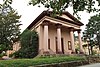 | June 24, 1971 (#71000605) | Cameron Ave., University of North Carolina campus 35°54′24″N 79°03′02″W / 35.906667°N 79.050556°W / 35.906667; -79.050556 (Playmakers Theatre) | Chapel Hill | |
| 45 | Capt. John S. Pope Farm | 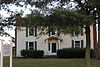 | April 23, 2013 (#13000206) | 6909 Efland-Cedar Grove Rd. 36°11′53″N 79°10′09″W / 36.198105°N 79.169107°W / 36.198105; -79.169107 (Capt. John S. Pope Farm) | Cedar Grove | |
| 46 | Ridge Road School | Upload image | December 12, 2023 (#100009620) | 2705 Coleman Loop Road 36°07′43″N 79°07′13″W / 36.1285°N 79.1203°W / 36.1285; -79.1203 (Ridge Road School) | Hillsborough vicinity | |
| 47 | Rigsbee's Rock House |  | October 20, 1988 (#88002026) | Jct. of Lawrence Rd. and US 70W Bypass 36°03′34″N 79°04′01″W / 36.059444°N 79.066944°W / 36.059444; -79.066944 (Rigsbee's Rock House) | Hillsborough | |
| 48 | Rocky Ridge Farm Historic District | 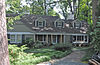 | August 8, 1989 (#89001039) | Roughly bounded by Rocky Ridge Rd., Country Club Rd., Laurel Hill Rd., Laurel Hill Cir., and Buttons Dr.; also portions of Country Club Rd., Laurel Hill Rd., and Ledge Ln., and all of Round Hill Rd. 35°54′21″N 79°02′18″W / 35.905833°N 79.038333°W / 35.905833; -79.038333 (Rocky Ridge Farm Historic District) | Chapel Hill | Second set of boundaries represents a boundary increase of January 30, 2008 |
| 49 | Ruffin-Roulhac House |  | August 5, 1971 (#71000612) | Churton and Orange Sts. 36°04′54″N 79°05′58″W / 36.081667°N 79.099444°W / 36.081667; -79.099444 (Ruffin-Roulhac House) | Hillsborough | |
| 50 | Sans Souci | 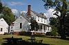 | August 26, 1971 (#71000613) | E. Corbin St. 36°04′56″N 79°05′37″W / 36.082222°N 79.093611°W / 36.082222; -79.093611 (Sans Souci) | Hillsborough | |
| 51 | St. Mary's Chapel |  | July 12, 1978 (#78001968) | NE of Hillsborough 36°07′03″N 79°00′01″W / 36.1175°N 79.000278°W / 36.1175; -79.000278 (St. Mary's Chapel) | Hillsborough | |
| 52 | St. Matthew's Episcopal Church and Churchyard | 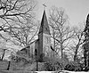 | June 24, 1971 (#71000614) | St. Mary's Rd. 36°04′35″N 79°05′43″W / 36.076389°N 79.095278°W / 36.076389; -79.095278 (St. Matthew's Episcopal Church and Churchyard) | Hillsborough | |
| 53 | Schley Grange Hall | 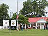 | April 23, 2020 (#100005203) | 3416 Schley Rd. 36°09′12″N 79°03′48″W / 36.1533°N 79.0633°W / 36.1533; -79.0633 (Schley Grange Hall) | Schley | |
| 54 | West Chapel Hill Historic District |  | December 31, 1998 (#98001528) | Roughly bounded by W. Cameron Ave., Malette St., Ranson St., Pittsboro St., University Dr. and the Westwood Subdivision; also roughly bounded by W. Franklin, S. Columbia, and Pittsboro Sts., Brookside and Dogwood Drs., and the E end of McCauley St. and W. Patterson Pl., 35°54′23″N 79°03′31″W / 35.906389°N 79.058611°W / 35.906389; -79.058611 (West Chapel Hill Historic District) | Chapel Hill | Second set of addresses represent a boundary increase approved May 9, 2019 |
See also
Wikimedia Commons has media related to National Register of Historic Places in Orange County, North Carolina.
- National Register of Historic Places listings in North Carolina
- List of National Historic Landmarks in North Carolina
References
- ^ The latitude and longitude information provided in this table was derived originally from the National Register Information System, which has been found to be fairly accurate for about 99% of listings. Some locations in this table may have been corrected to current GPS standards.
- ^ National Park Service, United States Department of the Interior, "National Register of Historic Places: Weekly List Actions", retrieved June 7, 2024.
- ^ Numbers represent an alphabetical ordering by significant words. Various colorings, defined here, differentiate National Historic Landmarks and historic districts from other NRHP buildings, structures, sites or objects.
- ^ "National Register Information System". National Register of Historic Places. National Park Service. April 24, 2008.
- ^ The eight-digit number below each date is the number assigned to each location in the National Register Information System database, which can be viewed by clicking the number.
- v
- t
- e

by county
- Alamance
- Alexander
- Alleghany
- Anson
- Ashe
- Avery
- Beaufort
- Bertie
- Bladen
- Brunswick
- Buncombe
- Burke
- Cabarrus
- Caldwell
- Camden
- Carteret
- Caswell
- Catawba
- Chatham
- Cherokee
- Chowan
- Clay
- Cleveland
- Columbus
- Craven
- Cumberland
- Currituck
- Dare
- Davidson
- Davie
- Duplin
- Durham
- Edgecombe
- Forsyth
- Franklin
- Gaston
- Gates
- Graham
- Granville
- Greene
- Guilford
- Halifax
- Harnett
- Haywood
- Henderson
- Hertford
- Hoke
- Hyde
- Iredell
- Jackson
- Johnston
- Jones
- Lee
- Lenoir
- Lincoln
- Macon
- Madison
- Martin
- McDowell
- Mecklenburg
- Mitchell
- Montgomery
- Moore
- Nash
- New Hanover
- Northampton
- Onslow
- Orange
- Pamlico
- Pasquotank
- Pender
- Perquimans
- Person
- Pitt
- Polk
- Randolph
- Richmond
- Robeson
- Rockingham
- Rowan
- Rutherford
- Sampson
- Scotland
- Stanly
- Stokes
- Surry
- Swain
- Transylvania
- Tyrrell
- Union
- Vance
- Wake
- Warren
- Washington
- Watauga
- Wayne
- Wilkes
- Wilson
- Yadkin
- Yancey
| |
|---|---|
| Topics | |
| Lists by state |
|
| Lists by insular areas | |
| Lists by associated state | |
| Other areas | |
| Related | |
| |


