National Register of Historic Places listings in Los Angeles County, California

This is a list of the National Register of Historic Places listings in Los Angeles County, California.
This is intended to be a complete list of the properties and districts on the National Register of Historic Places in Los Angeles County, California, excluding the cities of Los Angeles and Pasadena. The locations of National Register properties and districts for which the latitude and longitude coordinates are included below, may be seen in an online map.[1]
There are 605 properties and districts listed on the National Register in the county, including 21 National Historic Landmarks. Los Angeles is the location of more than 250 of these properties and districts, including 11 National Historic Landmarks; they are listed separately. Pasadena is the location of 128 of these properties and districts, including 5 National Historic Landmarks; they, too, are listed separately. The 201 properties and districts located elsewhere in the county, including 5 National Historic Landmarks, are listed here. A single district, the Arroyo Seco Parkway Historic District, passes through both cities and other parts of the county. Another 6 properties, including 5 outside these two cities, were once listed on the National Register but have been removed.
This National Park Service list is complete through NPS recent listings posted June 7, 2024.[2]
Map all coordinates using OpenStreetMap
Download coordinates as:
- KML
- GPX (all coordinates)
- GPX (primary coordinates)
- GPX (secondary coordinates)
Current listings
| [3] | Name on the Register[4] | Image | Date listed[5] | Location | City or town | Description |
|---|---|---|---|---|---|---|
| 1 | Adamson House | 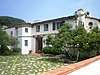 | October 28, 1977 (#77000298) | 23200 W. Pacific Coast Highway 34°02′04″N 118°40′42″W / 34.034444°N 118.678333°W / 34.034444; -118.678333 (Adamson House) | Malibu | |
| 2 | Adobe Flores |  | June 18, 1973 (#73000404) | 1804 Foothill St. 34°07′11″N 118°08′41″W / 34.119722°N 118.144722°W / 34.119722; -118.144722 (Adobe Flores) | South Pasadena | |
| 3 | Alexander Theatre |  | February 16, 1996 (#96000102) | 216 N. Brand Blvd. 34°08′57″N 118°15′12″W / 34.149167°N 118.253333°W / 34.149167; -118.253333 (Alexander Theatre) | Glendale | |
| 4 | Anderton Court Shops |  | May 14, 2004 (#03000987) | 332 N.Rodeo Dr. 34°04′06″N 118°24′03″W / 34.068333°N 118.400833°W / 34.068333; -118.400833 (Anderton Court Shops) | Beverly Hills | Frank Lloyd Wright |
| 5 | Antelope Valley Indian Museum |  | February 26, 1987 (#87000509) | 15701 East Ave. 34°39′01″N 117°50′56″W / 34.650278°N 117.848889°W / 34.650278; -117.848889 (Antelope Valley Indian Museum) | Lancaster | Chalet-style building set into rock formations, originally as a home |
| 6 | Ard Eevin |  | November 21, 2006 (#06001087) | 851 W. Mountain St. 34°10′37″N 118°16′13″W / 34.176944°N 118.270278°W / 34.176944; -118.270278 (Ard Eevin) | Glendale | |
| 7 | Arroyo Seco Parkway Historic District |  | February 4, 2011 (#10001198) | CA 110 from Four Level Interchange in Los Angeles to East Glenarm St. in Pasadena 34°07′39″N 118°08′50″W / 34.1275°N 118.147222°W / 34.1275; -118.147222 (Arroyo Seco Parkway Historic District) | Downtown Los Angeles to Pasadena | The Arroyo Seco Parkway Historic District passes through South Pasadena |
| 8 | Atchison, Topeka, and Santa Fe Railroad Station |  | July 15, 1982 (#82002188) | 110 W. 1st St. 34°05′39″N 117°42′58″W / 34.094167°N 117.716111°W / 34.094167; -117.716111 (Atchison, Topeka, and Santa Fe Railroad Station) | Claremont | Spanish Colonial Revival train station built in 1927, now an art museum |
| 9 | Auditorium |  | October 13, 1983 (#83003499) | 2200 W. Carson 33°49′48″N 118°19′11″W / 33.83°N 118.319722°W / 33.83; -118.319722 (Auditorium) | Torrance | |
| 10 | Aztec Hotel |  | May 22, 1978 (#78000691) | 311 W. Foothill Blvd. 34°09′06″N 118°00′18″W / 34.151667°N 118.005°W / 34.151667; -118.005 (Aztec Hotel) | Monrovia | |
| 11 | Azusa Civic Center |  | February 21, 2002 (#02000034) | 213 Foothill Blvd. 34°08′03″N 117°54′18″W / 34.134167°N 117.905°W / 34.134167; -117.905 (Azusa Civic Center) | Azusa | |
| 12 | Jonathan Bailey House | 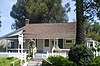 | August 29, 1977 (#77000304) | 13421 E. Camilla St. 33°59′05″N 118°01′53″W / 33.984722°N 118.031389°W / 33.984722; -118.031389 (Jonathan Bailey House) | Whittier | |
| 13 | Bay Street Beach Historic District |  | June 26, 2019 (#100004116) | Roughly bounded by Pacific Ocean, Ocean Front Walk from Vicente Ter. to Crescent Bay Park, Bicknell Ave. extending into ocean. 34°00′23″N 118°29′31″W / 34.0065°N 118.4919°W / 34.0065; -118.4919 (Bay Street Beach Historic District) | Santa Monica | |
| 14 | Beverly Hills Women's Club | 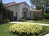 | October 4, 2006 (#06000914) | 1700 Chevy Chase Dr. 34°05′09″N 118°25′47″W / 34.085833°N 118.429722°W / 34.085833; -118.429722 (Beverly Hills Women's Club) | Beverly Hills | |
| 15 | Beverly Wilshire Hotel |  | June 12, 1987 (#87000908) | 9528 Wilshire Blvd. 34°04′01″N 118°23′20″W / 34.066944°N 118.388889°W / 34.066944; -118.388889 (Beverly Wilshire Hotel) | Beverly Hills | |
| 16 | Luther and Adah Blair House | Upload image | March 25, 2024 (#100010098) | 508 S. Ivy Avenue 34°08′48″N 117°59′55″W / 34.1466°N 117.9987°W / 34.1466; -117.9987 (Luther and Adah Blair House) | Monrovia | |
| 17 | John F. and Julia Brossart House | Upload image | March 25, 2024 (#100010097) | 512 S. Ivy Avenue 34°08′48″N 117°59′55″W / 34.1467°N 117.9987°W / 34.1467; -117.9987 (John F. and Julia Brossart House) | Monrovia | |
| 18 | CA-LAN-1258 | Upload image | October 17, 2012 (#12000861) | Address Restricted | Canyon Country | |
| 19 | CA-LAN-1302 | Upload image | October 17, 2012 (#12000862) | Address Restricted | Azusa | |
| 20 | CA-LAN-1946 | Upload image | October 17, 2012 (#12000860) | Address Restricted | Acton | |
| 21 | CA-LAN-441 | Upload image | October 17, 2012 (#12000863) | Address Restricted | Castaic | |
| 22 | CA-LAN-540 |  | October 17, 2012 (#12000859) | Address Restricted | Agua Dulce | |
| 23 | Casa de Parley Johnson | 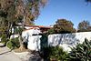 | March 20, 1986 (#86000449) | 7749 Florence Ave. 33°57′24″N 118°07′57″W / 33.9567°N 118.1325°W / 33.9567; -118.1325 (Casa de Parley Johnson) | Downey | |
| 24 | Case Study House No. 20 |  | July 24, 2013 (#13000517) | 2275 N. Santa Rosa Ave. 34°11′05″N 118°08′20″W / 34.1847°N 118.1388°W / 34.1847; -118.1388 (Case Study House No. 20) | Altadena | One of the Case Study Houses, built in 1958 for Saul Bass. |
| 25 | Cedar Avenue Complex | Upload image | September 30, 1993 (#93001017) | 44843 (44855), 44845 and 44851 Cedar Ave., 606 Lancaster Blvd., and Old Jail (no address) 34°41′58″N 118°08′20″W / 34.6994°N 118.1389°W / 34.6994; -118.1389 (Cedar Avenue Complex) | Lancaster | |
| 26 | Charmont Apartments |  | July 25, 1996 (#96000777) | 330 California Ave. 34°01′12″N 118°29′58″W / 34.02°N 118.4994°W / 34.02; -118.4994 (Charmont Apartments) | Santa Monica | |
| 27 | Chicano Moratorium March December 20, 1969 | Upload image | October 30, 2020 (#100002655) | Five Points Memorial, North Indiana St., Michigan Ave., Obregon Park 34°02′17″N 118°11′33″W / 34.0381°N 118.1925°W / 34.0381; -118.1925 (Chicano Moratorium March December 20, 1969) | East Los Angeles | |
| 28 | Christian Science Society | Upload image | July 10, 2017 (#100001281) | 209 E. Whittley Ave. 33°20′39″N 118°19′41″W / 33.3442°N 118.3281°W / 33.3442; -118.3281 (Christian Science Society) | Avalon | |
| 29 | Christmas Tree Lane |  | September 13, 1990 (#90001444) | Santa Rosa Ave. between Woodbury Ave. and Altadena Dr. 34°11′25″N 118°08′09″W / 34.1903°N 118.1358°W / 34.1903; -118.1358 (Christmas Tree Lane) | Altadena | |
| 30 | Citizens Publishing Company Building |  | February 12, 1987 (#87000082) | 9355 Culver Blvd. 34°01′31″N 118°23′35″W / 34.0253°N 118.3931°W / 34.0253; -118.3931 (Citizens Publishing Company Building) | Culver City | |
| 31 | City Hall-City of Burbank |  | April 18, 1996 (#96000426) | 275 E. Olive Ave. 34°10′55″N 118°18′27″W / 34.1819°N 118.3075°W / 34.1819; -118.3075 (City Hall-City of Burbank) | Burbank | |
| 32 | Clarke Estate |  | January 4, 1990 (#89002267) | 10211 Pioneer Blvd. 33°56′36″N 118°04′52″W / 33.9433°N 118.0811°W / 33.9433; -118.0811 (Clarke Estate) | Santa Fe Springs | |
| 33 | Club Casa Del Mar |  | September 29, 2000 (#00001169) | 1910 Ocean Ave. 34°00′23″N 118°29′25″W / 34.0064°N 118.4903°W / 34.0064; -118.4903 (Club Casa Del Mar) | Santa Monica | |
| 34 | Colonial House |  | April 15, 1982 (#82002190) | 1416 N. Havenhurst Dr. 34°05′45″N 118°21′35″W / 34.0958°N 118.3597°W / 34.0958; -118.3597 (Colonial House) | West Hollywood | |
| 35 | Community Clubhouse |  | July 23, 2013 (#13000510) | 1200 N. Vista St. 34°05′37″N 118°21′04″W / 34.0937°N 118.3512°W / 34.0937; -118.3512 (Community Clubhouse) | West Hollywood | |
| 36 | Cooper Arms |  | December 28, 2000 (#00001538) | 455 E. Ocean Blvd. 33°46′01″N 118°11′13″W / 33.7669°N 118.1869°W / 33.7669; -118.1869 (Cooper Arms) | Long Beach | |
| 37 | Crank House |  | July 23, 1997 (#97000751) | 2186 Crary St. 34°10′21″N 118°06′20″W / 34.1725°N 118.1056°W / 34.1725; -118.1056 (Crank House) | Altadena | |
| 38 | Culver Hotel |  | April 14, 1997 (#97000296) | 9400 Culver Blvd. 34°01′24″N 118°23′38″W / 34.0233°N 118.3939°W / 34.0233; -118.3939 (Culver Hotel) | Culver City | |
| 39 | James Daniel Derby House |  | December 14, 1978 (#78000682) | 2535 E. Chevy Chase Dr. 34°09′41″N 118°12′38″W / 34.1614°N 118.2106°W / 34.1614; -118.2106 (James Daniel Derby House) | Glendale | |
| 40 | Descanso Gardens |  | April 19, 2021 (#100005157) | 1418 Descanso Dr. 34°12′05″N 118°12′35″W / 34.2015°N 118.2098°W / 34.2015; -118.2098 (Descanso Gardens) | La Cañada Flintridge | |
| 41 | DeWenter Mansion, Guest House and Grounds | Upload image | November 5, 1992 (#92001559) | 6100 Brydon Rd. 34°09′07″N 117°45′23″W / 34.1519°N 117.7564°W / 34.1519; -117.7564 (DeWenter Mansion, Guest House and Grounds) | La Verne | |
| 42 | Diamond Apartments |  | March 26, 1992 (#92000260) | 321 Diamond St. 33°50′39″N 118°23′16″W / 33.8442°N 118.3878°W / 33.8442; -118.3878 (Diamond Apartments) | Redondo Beach | |
| 43 | Doctors House |  | September 21, 2023 (#100009362) | 1601 West Mountain St. (Brand Park) 34°10′57″N 118°16′36″W / 34.1826°N 118.2767°W / 34.1826; -118.2767 (Doctors House) | Glendale | |
| 44 | Doheny Estate/Greystone Mansion |  | April 23, 1976 (#76000485) | 905 Loma Vista Dr. 34°05′31″N 118°24′01″W / 34.0919°N 118.4003°W / 34.0919; -118.4003 (Doheny Estate/Greystone Mansion) | Beverly Hills | |
| 45 | Dominguez Rancho Adobe |  | May 28, 1976 (#76000486) | 18127 S. Alameda St. 33°52′01″N 118°13′03″W / 33.8669°N 118.2175°W / 33.8669; -118.2175 (Dominguez Rancho Adobe) | Compton | |
| 46 | Peter Drucker House |  | December 18, 2017 (#100001890) | 636 Wellesley Dr. 34°06′38″N 117°43′31″W / 34.1105°N 117.7254°W / 34.1105; -117.7254 (Peter Drucker House) | Claremont | Home of Peter Drucker |
| 47 | Edison Historic District |  | August 13, 1986 (#86001477) | 611, 637, and 500 block of W. Second St. 34°03′28″N 117°45′13″W / 34.0578°N 117.7536°W / 34.0578; -117.7536 (Edison Historic District) | Pomona | |
| 48 | El Molino Viejo |  | May 6, 1971 (#71000154) | 1120 Old Mill Rd. 34°07′08″N 118°07′41″W / 34.119°N 118.128°W / 34.119; -118.128 (El Molino Viejo) | San Marino | Water-driven grist mill built ca. 1816; oldest commercial building in Southern California |
| 49 | El Segundo Woman's Club | Upload image | May 30, 2023 (#100009028) | 541 Standard St. 33°55′24″N 118°24′54″W / 33.9234°N 118.4149°W / 33.9234; -118.4149 (El Segundo Woman's Club) | El Segundo | |
| 50 | Katherine Emery Estate |  | January 10, 2011 (#10001118) | 1155 Oak Grove Ave. 34°07′31″N 118°07′38″W / 34.1253°N 118.1272°W / 34.1253; -118.1272 (Katherine Emery Estate) | San Marino | |
| 51 | Episcopal Church of the Ascension |  | August 19, 1977 (#77000303) | 25 E. Laurel Ave. 34°09′58″N 118°03′04″W / 34.1661°N 118.0511°W / 34.1661; -118.0511 (Episcopal Church of the Ascension) | Sierra Madre | |
| 52 | Gen. Charles S. Farnsworth County Park |  | February 7, 1997 (#97000027) | 568 E. Mt. Curve Ave. 34°11′59″N 118°07′54″W / 34.1997°N 118.1317°W / 34.1997; -118.1317 (Gen. Charles S. Farnsworth County Park) | Altadena | |
| 53 | Federal Building |  | April 28, 2015 (#15000169) | 15000 Aviation Blvd. 33°53′42″N 118°22′40″W / 33.8951°N 118.3777°W / 33.8951; -118.3777 (Federal Building) | Hawthorne | |
| 54 | Fern Avenue School |  | February 20, 1992 (#92000067) | 1314 Fern Ave. 33°50′06″N 118°19′52″W / 33.835°N 118.3311°W / 33.835; -118.3311 (Fern Avenue School) | Torrance | |
| 55 | First Congregational Church of Long Beach |  | September 25, 2012 (#12000810) | 241 Cedar Ave. 33°46′13″N 118°11′42″W / 33.7704°N 118.1951°W / 33.7704; -118.1951 (First Congregational Church of Long Beach) | Long Beach | |
| 56 | First National Bank of Long Beach |  | September 13, 1990 (#90001432) | 101-125 Pine Ave. 33°46′06″N 118°11′30″W / 33.7683°N 118.1917°W / 33.7683; -118.1917 (First National Bank of Long Beach) | Long Beach | |
| 57 | Forum |  | September 24, 2014 (#14000661) | 3900 Manchester Blvd. 33°57′29″N 118°20′31″W / 33.9581°N 118.3419°W / 33.9581; -118.3419 (Forum) | Inglewood | |
| 58 | Fox Theatre Inglewood |  | January 14, 2013 (#12001163) | 115 N. Market St. 33°57′48″N 118°21′08″W / 33.9633°N 118.3523°W / 33.9633; -118.3523 (Fox Theatre Inglewood) | Inglewood | |
| 59 | Fox Wilshire Theatre |  | April 3, 2012 (#12000164) | 8440 Wilshire Blvd. 34°03′53″N 118°22′30″W / 34.0647°N 118.3750°W / 34.0647; -118.3750 (Fox Wilshire Theatre) | Beverly Hills | |
| 60 | Peter Gano House |  | September 15, 1983 (#83001194) | 718 Crescent Ave. 33°20′34″N 118°19′20″W / 33.3428°N 118.3222°W / 33.3428; -118.3222 (Peter Gano House) | Avalon | |
| 61 | Garfield House |  | April 24, 1973 (#73000405) | 1001 Buena Vista St. 34°07′14″N 118°09′21″W / 34.1206°N 118.1558°W / 34.1206; -118.1558 (Garfield House) | South Pasadena | |
| 62 | Glendale Southern Pacific Railroad Depot |  | May 2, 1997 (#97000376) | Gardena Ave., junction with W. Cerritos Ave. 34°07′25″N 118°15′29″W / 34.1236°N 118.2581°W / 34.1236; -118.2581 (Glendale Southern Pacific Railroad Depot) | Glendale | |
| 63 | Glendale Young Men's Christian Association |  | October 21, 1994 (#94001224) | 140 N. Louise St. 34°08′52″N 118°15′04″W / 34.1478°N 118.2511°W / 34.1478; -118.2511 (Glendale Young Men's Christian Association) | Glendale | |
| 64 | Glendora Bougainvillea |  | February 7, 1978 (#78000683) | Bennett and Minnesota Aves. 34°08′27″N 117°51′34″W / 34.1408°N 117.8594°W / 34.1408; -117.8594 (Glendora Bougainvillea) | Glendora | |
| 65 | Grand Central Air Terminal |  | March 27, 2017 (#100000780) | 1310 Air Way 34°09′47″N 118°17′12″W / 34.1631°N 118.2866°W / 34.1631; -118.2866 (Grand Central Air Terminal) | Glendale | |
| 66 | Green-Rankin-Bembridge House |  | February 10, 2005 (#05000002) | 953 Park Circle Dr. 33°46′45″N 118°12′04″W / 33.779167°N 118.201111°W / 33.779167; -118.201111 (Green-Rankin-Bembridge House) | Long Beach | |
| 67 | Barbara Greenwood Kindergarten |  | September 18, 1978 (#78000697) | Hacienda Pl. and McKinley Ave. 34°04′32″N 117°45′19″W / 34.075494°N 117.755318°W / 34.075494; -117.755318 (Barbara Greenwood Kindergarten) | Pomona | |
| 68 | Zane Grey Estate |  | October 24, 2002 (#02001187) | 396 E. Mariposa St. 34°11′26″N 118°08′30″W / 34.190556°N 118.141667°W / 34.190556; -118.141667 (Zane Grey Estate) | Altadena | |
| 69 | Hacienda Arms Apartments |  | December 15, 1983 (#83003531) | 8439 Sunset Blvd. 34°05′42″N 118°22′24″W / 34.095°N 118.373333°W / 34.095; -118.373333 (Hacienda Arms Apartments) | West Hollywood | |
| 70 | Olan G. and Aida T. Hafley House |  | July 12, 2011 (#11000429) | 5561 E. La Pasada St. 33°46′54″N 118°07′30″W / 33.781667°N 118.125°W / 33.781667; -118.125 (Olan G. and Aida T. Hafley House) | Long Beach | 1953 house designed by Richard Neutra[6][7] |
| 71 | Hawkins-Nimocks Estate-Patricio Ontiveros Adobe |  | December 31, 1987 (#82004982) | 12100 Telegraph Rd. 33°56′22″N 118°04′34″W / 33.939444°N 118.076111°W / 33.939444; -118.076111 (Hawkins-Nimocks Estate-Patricio Ontiveros Adobe) | Santa Fe Springs | |
| 72 | Home Economics Building | 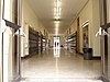 | October 13, 1983 (#83003536) | 2200 W. Carson 33°49′52″N 118°19′16″W / 33.831111°N 118.321111°W / 33.831111; -118.321111 (Home Economics Building) | Torrance | |
| 73 | Hoover Hotel |  | February 1, 2002 (#02000074) | 7035 Greenleaf Ave. 33°58′41″N 118°02′10″W / 33.978056°N 118.036111°W / 33.978056; -118.036111 (Hoover Hotel) | Whittier | |
| 74 | Horatio West Court |  | April 11, 1977 (#77000302) | 140 Hollister Ave. 34°00′12″N 118°29′10″W / 34.003333°N 118.486111°W / 34.003333; -118.486111 (Horatio West Court) | Santa Monica | Irving Gill |
| 75 | Hotel Glendale |  | October 7, 1994 (#94001197) | 701 E. Broadway 34°08′48″N 118°14′45″W / 34.146667°N 118.245833°W / 34.146667; -118.245833 (Hotel Glendale) | Glendale | |
| 76 | Edwin Hubble House |  | December 8, 1976 (#76000494) | 1340 Woodstock Rd. 34°07′23″N 118°07′12″W / 34.123056°N 118.12°W / 34.123056; -118.12 (Edwin Hubble House) | San Marino | |
| 77 | Humaliwo | Upload image | September 1, 1976 (#76000492) | Address Restricted | Malibu | |
| 78 | Hunt House | Upload image | June 26, 2019 (#100004118) | 24514 Malibu Rd. 34°01′50″N 118°42′33″W / 34.0306°N 118.7092°W / 34.0306; -118.7092 (Hunt House) | Malibu | |
| 79 | Intercultural Council Houses |  | April 7, 2015 (#15000121) | Bounded by Blanchard Pl., Claremont Blvd., E. 1st & Brooks Sts. 34°05′45″N 117°42′18″W / 34.0958°N 117.7050°W / 34.0958; -117.7050 (Intercultural Council Houses) | Claremont | Site of planned interracial community in the 1940s[8][9] |
| 80 | Darius David Johnston House |  | November 2, 1978 (#78000693) | 12426 Mapledale St. 33°53′54″N 118°04′02″W / 33.898333°N 118.067222°W / 33.898333; -118.067222 (Darius David Johnston House) | Norwalk | |
| 81 | Orin Jordan House |  | July 28, 1980 (#80000815) | 8310 S. Comstock Ave. 33°57′40″N 118°01′59″W / 33.961111°N 118.033056°W / 33.961111; -118.033056 (Orin Jordan House) | Whittier | |
| 82 | Karasik House |  | December 22, 2011 (#11000933) | 436 Spalding Dr. 34°03′28″N 118°24′32″W / 34.057786°N 118.408883°W / 34.057786; -118.408883 (Karasik House) | Beverly Hills | |
| 83 | Keyes Bungalow |  | November 14, 1978 (#78000678) | 1337 E. Boston St. 34°10′57″N 118°07′22″W / 34.1825°N 118.122778°W / 34.1825; -118.122778 (Keyes Bungalow) | Altadena | |
| 84 | Killingsworth, Brady, & Smith |  | July 15, 2009 (#09000515) | 3827-3837 Long Beach Blvd. 33°49′41″N 118°11′23″W / 33.828056°N 118.189656°W / 33.828056; -118.189656 (Killingsworth, Brady, & Smith) | Long Beach | |
| 85 | La Casa Alvarado |  | April 19, 1978 (#78000698) | 1459 Old Settlers Lane 34°04′26″N 117°45′19″W / 34.073889°N 117.755278°W / 34.073889; -117.755278 (La Casa Alvarado) | Pomona | |
| 86 | La Casa Primera de Rancho San Jose |  | April 3, 1975 (#75000436) | 1569 N. Park Ave. 34°04′30″N 117°45′15″W / 34.075°N 117.754167°W / 34.075; -117.754167 (La Casa Primera de Rancho San Jose) | Pomona | |
| 87 | La Laguna de San Gabriel |  | January 11, 2017 (#100000462) | 300 W. Wells St. 34°05′01″N 118°06′16″W / 34.083558°N 118.104390°W / 34.083558; -118.104390 (La Laguna de San Gabriel) | San Gabriel | |
| 88 | La Puente Valley Woman's Club |  | April 29, 1999 (#99000482) | 200 N. First St. 34°01′19″N 117°57′05″W / 34.021944°N 117.951389°W / 34.021944; -117.951389 (La Puente Valley Woman's Club) | La Puente | |
| 89 | Lanterman House |  | December 29, 1994 (#94001504) | 4420 Encinas Dr. 34°12′16″N 118°12′20″W / 34.204444°N 118.205556°W / 34.204444; -118.205556 (Lanterman House) | La Cañada Flintridge | |
| 90 | Leonis Adobe |  | May 29, 1975 (#75000433) | 23537 Calabasas Rd. 34°09′26″N 118°38′24″W / 34.157192°N 118.639881°W / 34.157192; -118.639881 (Leonis Adobe) | Calabasas | |
| 91 | Lincoln Park Historic District |  | April 9, 2004 (#03001347) | Roughly bounded by McKinley Ave., Towne Ave., Pasadena St. and Garey Ave. 34°04′14″N 117°44′42″W / 34.070466°N 117.745087°W / 34.070466; -117.745087 (Lincoln Park Historic District) | Pomona | |
| 92 | Abraham Lincoln Elementary School |  | August 3, 1989 (#89000935) | 1200 N. Gordon Ave. 34°04′13″N 117°45′08″W / 34.070278°N 117.752222°W / 34.070278; -117.752222 (Abraham Lincoln Elementary School) | Pomona | |
| 93 | Harold Lloyd Estate |  | February 9, 1984 (#84000876) | 1740 Green Acres Drive 34°05′17″N 118°25′37″W / 34.088106°N 118.426939°W / 34.088106; -118.426939 (Harold Lloyd Estate) | Beverly Hills | |
| 94 | Long Beach Professional Building | 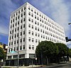 | August 3, 2005 (#05000773) | 117 E. 8th St. 33°46′36″N 118°11′32″W / 33.776667°N 118.192222°W / 33.776667; -118.192222 (Long Beach Professional Building) | Long Beach | |
| 95 | Howard Longley House | 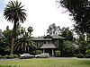 | April 16, 1974 (#74000527) | 1005 Buena Vista St. 34°07′14″N 118°09′19″W / 34.120556°N 118.155278°W / 34.120556; -118.155278 (Howard Longley House) | South Pasadena | |
| 96 | Lopez Adobe |  | May 6, 1971 (#71000157) | 1100 Pico St. 34°16′55″N 118°26′33″W / 34.281944°N 118.4425°W / 34.281944; -118.4425 (Lopez Adobe) | San Fernando | |
| 97 | Los Cerritos Ranch House |  | April 15, 1970 (#70000135) | 4600 Virginia Rd. 33°50′22″N 118°11′42″W / 33.839444°N 118.195°W / 33.839444; -118.195 (Los Cerritos Ranch House) | Long Beach | |
| 98 | Lynwood Pacific Electric Railway Depot |  | September 25, 1974 (#74000524) | 11453 Long Beach Blvd. 33°55′32″N 118°12′34″W / 33.925556°N 118.209444°W / 33.925556; -118.209444 (Lynwood Pacific Electric Railway Depot) | Lynwood | |
| 99 | Main Building |  | October 13, 1983 (#83003538) | 2200 W. Carson 33°49′51″N 118°19′13″W / 33.830833°N 118.320278°W / 33.830833; -118.320278 (Main Building) | Torrance | |
| 100 | Malaga Cove Plaza | 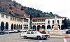 | October 1, 2021 (#100007016) | Roughly bounded by Palos Verdes Drive West, Vía Tejon, Vía Corta, and Malaga Ln Coordinates missing | Palos Verdes Estates | |
| 101 | Malibu Historic District |  | January 29, 2018 (#100002022) | Roughly along Pacific Coast from east of Malibu Pier to the Malibu Colony privacy fence 34°02′13″N 118°40′35″W / 34.037083°N 118.67651°W / 34.037083; -118.67651 (Malibu Historic District) | Malibu | [10][11][12][13] |
| 102 | Mariposa Street Bridge | Upload image | March 25, 2024 (#100010110) | Roughly 10 feet (3.0 m) s. of junction of S. Mariposa St. and W. Valley Heart Dr. 34°09′20″N 118°18′46″W / 34.1556°N 118.3127°W / 34.1556; -118.3127 (Mariposa Street Bridge) | Burbank | |
| 103 | Mayfair Hotel |  | July 31, 2017 (#100001382) | 115 E. 3rd St. 34°03′26″N 117°44′59″W / 34.057148°N 117.749776°W / 34.057148; -117.749776 (Mayfair Hotel) | Pomona | |
| 104 | McNally's Windemere Ranch Headquarters |  | July 20, 1978 (#78000684) | San Esteban and San Cristobal Dr. 33°53′53″N 118°01′28″W / 33.898056°N 118.024444°W / 33.898056; -118.024444 (McNally's Windemere Ranch Headquarters) | La Mirada | |
| 105 | Andrew McNally House |  | March 27, 2007 (#07000245) | 654 E. Mariposa St. 34°11′20″N 118°08′10″W / 34.188889°N 118.136111°W / 34.188889; -118.136111 (Andrew McNally House) | Altadena | |
| 106 | Middough Brothers-Insurance Exchange Building |  | February 5, 2003 (#03000002) | 205 E. Broadway 33°46′09″N 118°11′24″W / 33.769167°N 118.19°W / 33.769167; -118.19 (Middough Brothers-Insurance Exchange Building) | Long Beach | |
| 107 | Isaac Milbank House | Upload image | July 21, 2023 (#100009159) | 236 Adelaide Dr. 34°01′45″N 118°30′48″W / 34.0291°N 118.5134°W / 34.0291; -118.5134 (Isaac Milbank House) | Santa Monica | |
| 108 | Miltimore House |  | March 24, 1972 (#72000235) | 1301 S. Chelten Way 34°06′41″N 118°08′30″W / 34.111389°N 118.141667°W / 34.111389; -118.141667 (Miltimore House) | South Pasadena | |
| 109 | Mirlo Gate Lodge Tower |  | April 22, 2019 (#100003633) | 4420 Via Valmonte 33°47′55″N 118°21′19″W / 33.7987°N 118.3554°W / 33.7987; -118.3554 (Mirlo Gate Lodge Tower) | Palos Verdes Estates | |
| 110 | Montebello Woman's Club |  | March 31, 1995 (#95000266) | 201 S. Park Ave. 34°00′35″N 118°06′17″W / 34.0097°N 118.1047°W / 34.0097; -118.1047 (Montebello Woman's Club) | Montebello | |
| 111 | Mount Lowe Railway | 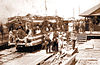 | January 6, 1993 (#92001522) | North of Altadena in Angeles NF 34°12′40″N 118°07′14″W / 34.2111°N 118.1206°W / 34.2111; -118.1206 (Mount Lowe Railway) | Altadena | |
| 112 | National Bank of Whittier Building |  | December 30, 1982 (#82000969) | 13002 E. Philadelphia St. 33°58′44″N 118°02′10″W / 33.9789°N 118.0361°W / 33.9789; -118.0361 (National Bank of Whittier Building) | Whittier | |
| 113 | National Chicano Moratorium March August 29, 1970 | Upload image | November 16, 2020 (#100002657) | East 3rd St., Beverly Blvd., Atlantic Ave., Whittier Blvd., and Salazar Park 34°01′26″N 118°11′27″W / 34.0239°N 118.1909°W / 34.0239; -118.1909 (National Chicano Moratorium March August 29, 1970) | East Los Angeles | |
| 114 | North Harper Avenue Historic District |  | June 28, 1996 (#96000694) | Roughly N. Harper Ave. between Fountain and De Longpre Aves. 34°05′42″N 118°22′04″W / 34.095°N 118.3678°W / 34.095; -118.3678 (North Harper Avenue Historic District) | West Hollywood | |
| 115 | Oaklawn Bridge and Waiting Station |  | July 16, 1973 (#73000406) | Between Oaklawn and Fair Oaks Aves. 34°07′08″N 118°09′08″W / 34.1189°N 118.1522°W / 34.1189; -118.1522 (Oaklawn Bridge and Waiting Station) | South Pasadena | |
| 116 | The Oaks | 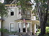 | April 6, 1978 (#78000692) | 250 N. Primrose Ave. 34°09′22″N 118°00′07″W / 34.1561°N 118.0019°W / 34.1561; -118.0019 (The Oaks) | Monrovia | |
| 117 | Pacific Electric Railroad Bridge |  | July 13, 1989 (#89000854) | Torrance Blvd. and Bow St. 33°50′15″N 118°18′39″W / 33.8375°N 118.3108°W / 33.8375; -118.3108 (Pacific Electric Railroad Bridge) | Torrance | |
| 118 | Pacific Electric Railway Company Substation No. 8 |  | November 9, 1977 (#77000295) | 2245 N. Lake Ave. 34°11′04″N 118°07′55″W / 34.1844°N 118.1319°W / 34.1844; -118.1319 (Pacific Electric Railway Company Substation No. 8) | Altadena | |
| 119 | Paddison Ranch Buildings |  | June 23, 1978 (#78000694) | 11951 Imperial Hwy. 33°55′05″N 118°04′35″W / 33.9181°N 118.0764°W / 33.9181; -118.0764 (Paddison Ranch Buildings) | Norwalk | |
| 120 | Padua Hills Theatre |  | January 23, 1998 (#97001660) | 4467 Via Padova 34°09′04″N 117°42′03″W / 34.1511°N 117.7008°W / 34.1511; -117.7008 (Padua Hills Theatre) | Claremont | Long-running theater that ran work featuring Mexican-American themes |
| 121 | Ygnacio Palomares Adobe |  | March 24, 1971 (#71000156) | Corner of Arrow Hwy. and Orange Grove Ave. 34°05′30″N 117°44′30″W / 34.0917°N 117.7417°W / 34.0917; -117.7417 (Ygnacio Palomares Adobe) | Pomona | |
| 122 | Palos Verdes Public Library and Art Gallery |  | April 7, 1995 (#95000388) | 2400 Via Campesina 33°47′58″N 118°23′13″W / 33.7994°N 118.3869°W / 33.7994; -118.3869 (Palos Verdes Public Library and Art Gallery) | Palos Verdes Estates | |
| 123 | Pan American National Bank of East Los Angeles |  | March 27, 2017 (#100000782) | 3620-3626 E. 1st St. 34°02′10″N 118°11′18″W / 34.0360°N 118.1883°W / 34.0360; -118.1883 (Pan American National Bank of East Los Angeles) | East Los Angeles | |
| 124 | Parkhurst Building |  | November 17, 1978 (#78000699) | 185 Pier Ave. 33°59′55″N 118°28′45″W / 33.9986°N 118.4792°W / 33.9986; -118.4792 (Parkhurst Building) | Santa Monica | |
| 125 | Patio del Moro |  | September 11, 1986 (#86002418) | 8225-8237 Fountain Ave. 34°05′41″N 118°22′03″W / 34.0947°N 118.3675°W / 34.0947; -118.3675 (Patio del Moro) | West Hollywood | |
| 126 | John Carlton Pegler House |  | October 20, 1988 (#88002019) | 419 E. Highland Ave. 34°09′56″N 118°02′44″W / 34.1656°N 118.0456°W / 34.1656; -118.0456 (John Carlton Pegler House) | Sierra Madre | |
| 127 | Phillips Mansion |  | November 6, 1974 (#74000525) | 2640 W. Pomona Blvd. 34°03′22″N 117°47′44″W / 34.0561°N 117.7956°W / 34.0561; -117.7956 (Phillips Mansion) | Pomona | |
| 128 | Pio Pico Casa |  | June 19, 1973 (#73000408) | 6003 Pioneer Blvd. 33°59′37″N 118°04′51″W / 33.9936°N 118.0808°W / 33.9936; -118.0808 (Pio Pico Casa) | Whittier | |
| 129 | Pioneer Oil Refinery | 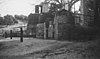 | December 11, 2020 (#100005942) | 0.35 mi. southwest of jct. of Pine St. and Newhall Ave. 34°22′27″N 118°31′24″W / 34.3741°N 118.5233°W / 34.3741; -118.5233 (Pioneer Oil Refinery) | Santa Clarita | |
| 130 | Pitzer House |  | September 4, 1986 (#86002192) | 4353 N. Towne 34°07′17″N 117°44′10″W / 34.1214°N 117.7361°W / 34.1214; -117.7361 (Pitzer House) | Claremont | Bungalow house |
| 131 | Point Vicente Light | 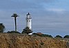 | October 31, 1980 (#80000808) | Rancho Palos Verdes 33°44′31″N 118°24′31″W / 33.7419°N 118.4086°W / 33.7419; -118.4086 (Point Vicente Light) | Rancho Palos Verdes | |
| 132 | Pomona City Stables |  | October 6, 2004 (#04001109) | 636 W. Monterey Ave. 34°03′33″N 117°45′31″W / 34.0592°N 117.7586°W / 34.0592; -117.7586 (Pomona City Stables) | Pomona | |
| 133 | Pomona Fox Theater |  | February 19, 1982 (#82002201) | 102-144 3rd St. 34°03′24″N 117°44′59″W / 34.0567°N 117.7497°W / 34.0567; -117.7497 (Pomona Fox Theater) | Pomona | |
| 134 | Pomona YMCA Building | 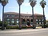 | March 6, 1986 (#86000408) | 350 N. Garey Ave. 34°03′36″N 117°44′56″W / 34.06°N 117.7489°W / 34.06; -117.7489 (Pomona YMCA Building) | Pomona | |
| 135 | Puvunga Indian Village Sites |  | January 21, 1974 (#74000521) | Address Restricted | Long Beach | |
| 136 | Queen Anne Cottage and Coach Barn |  | October 31, 1980 (#80000804) | 301 N. Baldwin Ave. 34°08′27″N 118°03′09″W / 34.1408°N 118.0525°W / 34.1408; -118.0525 (Queen Anne Cottage and Coach Barn) | Arcadia | Located in the Los Angeles County Arboretum and Botanic Garden |
| 137 | Rancho Los Alamitos |  | July 7, 1981 (#81000153) | 6400 Bixby Hill Rd. 33°46′38″N 118°06′19″W / 33.7772°N 118.1053°W / 33.7772; -118.1053 (Rancho Los Alamitos) | Long Beach | |
| 138 | Redondo Beach Original Townsite Historic District |  | June 30, 1988 (#88000970) | N. Gertruda Ave., Carnelian St., N. Guadalupe Ave. and Diamond St. 33°50′48″N 118°23′08″W / 33.8467°N 118.3856°W / 33.8467; -118.3856 (Redondo Beach Original Townsite Historic District) | Redondo Beach | |
| 139 | Redondo Beach Public Library | 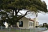 | March 12, 1981 (#81000158) | 309 Esplanade St. 33°50′16″N 118°23′20″W / 33.8378°N 118.3889°W / 33.8378; -118.3889 (Redondo Beach Public Library) | Redondo Beach | |
| 140 | Jennie A. Reeve House |  | June 21, 1984 (#84000883) | 4260 Country Club Dr. 33°50′03″N 118°11′41″W / 33.8342°N 118.1947°W / 33.8342; -118.1947 (Jennie A. Reeve House) | Long Beach | |
| 141 | Helen Goodwin Renwick House |  | June 7, 2016 (#16000322) | 146 N. College Ave. 34°05′44″N 117°42′53″W / 34.0955°N 117.7146°W / 34.0955; -117.7146 (Helen Goodwin Renwick House) | Claremont | Queen Anne home of philanthropist Helen Goodwin Renwick, currently owned by Pomona College |
| 142 | Rialto Theatre |  | May 24, 1978 (#78000700) | 1019-1023 Fair Oaks Ave. 34°06′50″N 118°08′59″W / 34.1139°N 118.1497°W / 34.1139; -118.1497 (Rialto Theatre) | South Pasadena | |
| 143 | Ridge Route |  | September 25, 1997 (#97001113) | Along Old Ridge Rte., roughly bounded by Sandberg and Canton Canyon 34°37′56″N 118°41′49″W / 34.6322°N 118.6969°W / 34.6322; -118.6969 (Ridge Route) | Castaic | Extends into Kern County |
| 144 | James C. Rives House |  | May 22, 1978 (#78000681) | 10921 S. Paramount Blvd. 33°56′42″N 118°08′10″W / 33.945°N 118.1361°W / 33.945; -118.1361 (James C. Rives House) | Downey | Actual address is 10933. |
| 145 | RMS Queen Mary |  | April 15, 1993 (#92001714) | Pier J, 1126 Queensway Hwy. 33°45′10″N 118°11′23″W / 33.7528°N 118.1897°W / 33.7528; -118.1897 (RMS Queen Mary) | Long Beach | |
| 146 | Virginia Robinson Estate |  | November 15, 1978 (#78000679) | 1008 Elden Way 34°05′11″N 118°25′00″W / 34.0864°N 118.4167°W / 34.0864; -118.4167 (Virginia Robinson Estate) | Beverly Hills | public gardens & house museum |
| 147 | Rockhaven Sanitarium Historic District |  | June 9, 2016 (#16000355) | 2713 Honolulu Ave. bounded by Pleasure Way, Hermosa & Honolulu Aves. 34°12′41″N 118°14′19″W / 34.2113°N 118.2385°W / 34.2113; -118.2385 (Rockhaven Sanitarium Historic District) | Glendale | |
| 148 | Ronda |  | February 28, 1985 (#85000356) | 1400-1414 Havenhurst Dr. 34°05′48″N 118°21′59″W / 34.0967°N 118.3664°W / 34.0967; -118.3664 (Ronda) | West Hollywood | |
| 149 | John A. Rowland House |  | July 16, 1973 (#73000403) | 16021 E. Gale Ave. 34°00′39″N 117°57′24″W / 34.0108°N 117.9567°W / 34.0108; -117.9567 (John A. Rowland House) | Industry | House built by pioneer John A. Rowland in 1855 |
| 150 | Rubel Castle Historic District |  | October 7, 2013 (#13000810) | 844 N. Live Oak Ave. 34°09′01″N 117°51′17″W / 34.150278°N 117.854722°W / 34.150278; -117.854722 (Rubel Castle Historic District) | Glendora | |
| 151 | Russian Village District |  | December 28, 1978 (#78000680) | 290-370 S. Mills Ave. and 480 Cucamonga Ave. 34°05′25″N 117°42′25″W / 34.090278°N 117.706944°W / 34.090278; -117.706944 (Russian Village District) | Claremont | 15 folk architecture style houses built by Konstanty ("Steve") Stys, a Polish immigrant, and others during the Great Depression |
| 152 | Saddle Rock Ranch Pictograph Site |  | February 12, 1982 (#82004617) | Address Restricted | Malibu | |
| 153 | San Dimas Hotel |  | March 16, 1972 (#72000233) | 121 San Dimas Ave. 34°06′27″N 117°48′23″W / 34.1075°N 117.806389°W / 34.1075; -117.806389 (San Dimas Hotel) | San Dimas | |
| 154 | San Gabriel Mission |  | May 6, 1971 (#71000158) | Junipero St. and W. Mission Dr. 34°05′52″N 118°06′22″W / 34.097778°N 118.106111°W / 34.097778; -118.106111 (San Gabriel Mission) | San Gabriel | |
| 155 | San Gabriel Mission Playhouse |  | July 22, 2019 (#100002674) | 320 S. Mission Dr. 34°05′53″N 118°06′32″W / 34.0980°N 118.1089°W / 34.0980; -118.1089 (San Gabriel Mission Playhouse) | San Gabriel | |
| 156 | San Rafael Rancho |  | December 12, 1976 (#76000487) | Bonita Dr. 34°10′49″N 118°13′55″W / 34.180278°N 118.231944°W / 34.180278; -118.231944 (San Rafael Rancho) | Glendale | |
| 157 | Santa Monica Looff Hippodrome |  | February 27, 1987 (#87000766) | 276 Santa Monica Pier 34°00′36″N 118°29′43″W / 34.01°N 118.495278°W / 34.01; -118.495278 (Santa Monica Looff Hippodrome) | Santa Monica | |
| 158 | J.W. Schaffer House |  | April 19, 2016 (#16000174) | 527 Whiting Woods Rd. 34°12′54″N 118°14′58″W / 34.214903°N 118.249476°W / 34.214903; -118.249476 (J.W. Schaffer House) | Glendale | |
| 159 | R. M. Schindler House |  | July 14, 1971 (#71000150) | 833 N. Kings Rd. 34°05′11″N 118°22′16″W / 34.086389°N 118.371111°W / 34.086389; -118.371111 (R. M. Schindler House) | West Hollywood | |
| 160 | Scripps College for Women |  | September 20, 1984 (#84000887) | Columbia and 10th St. 34°06′18″N 117°42′30″W / 34.105°N 117.708333°W / 34.105; -117.708333 (Scripps College for Women) | Claremont | Historic core of the private liberal arts women's college designed by Gordon Kaufmann in the Spanish Colonial Revival style |
| 161 | Scripps Hall |  | July 28, 1999 (#99000893) | 209 E. Mariposa St. 34°11′34″N 118°08′38″W / 34.192778°N 118.143889°W / 34.192778; -118.143889 (Scripps Hall) | Altadena | |
| 162 | Second Church of Christ Scientist |  | April 1, 2005 (#05000212) | 655 Cedar Ave. 33°44′55″N 118°11′35″W / 33.748611°N 118.193056°W / 33.748611; -118.193056 (Second Church of Christ Scientist) | Long Beach | |
| 163 | Security Trust and Savings Building |  | March 29, 2019 (#100003553) | 110 Pine Ave. 33°46′06″N 118°11′33″W / 33.7683°N 118.1924°W / 33.7683; -118.1924 (Security Trust and Savings Building) | Long Beach | |
| 164 | Upton Sinclair House |  | November 11, 1971 (#71000153) | 464 N. Myrtle Ave. 34°09′44″N 118°00′00″W / 34.162222°N 118.0°W / 34.162222; -118.0 (Upton Sinclair House) | Monrovia | |
| 165 | South Pasadena Historic District |  | July 21, 1982 (#82002202) | Roughly bounded by Mission and El Centro Sts., and Fairview and Meridian Aves. 34°07′01″N 118°09′23″W / 34.116944°N 118.156389°W / 34.116944; -118.156389 (South Pasadena Historic District) | South Pasadena | |
| 166 | Southern Pacific Railroad Depot, Whittier |  | March 29, 2005 (#04001105) | 7333 Greenleaf Ave. 33°58′28″N 118°02′15″W / 33.974444°N 118.0375°W / 33.974444; -118.0375 (Southern Pacific Railroad Depot, Whittier) | Whittier | Depot was originally listed in 1978 at its original location and was removed from the Register on October 1, 2004. It was returned to the Register at its new location in 2005. |
| 167 | Sovereign Hotel |  | October 24, 1997 (#97001236) | 205 Washington Ave. 34°01′13″N 118°30′07″W / 34.020278°N 118.501944°W / 34.020278; -118.501944 (Sovereign Hotel) | Santa Monica | |
| 168 | Standard Oil Building |  | June 9, 1980 (#80000816) | 7257 Bright Ave. 33°58′33″N 118°02′08″W / 33.975833°N 118.035556°W / 33.975833; -118.035556 (Standard Oil Building) | Whittier | |
| 169 | Stevens House | Upload image | October 9, 2009 (#09000802) | 23524 Malibu Colony Rd. 34°01′55″N 118°41′14″W / 34.031839°N 118.687214°W / 34.031839; -118.687214 (Stevens House) | Malibu | |
| 170 | Charles E. Straight House |  | July 8, 1992 (#92000833) | 4333 Emerald Ave. 34°07′03″N 117°46′04″W / 34.1175°N 117.767778°W / 34.1175; -117.767778 (Charles E. Straight House) | La Verne | |
| 171 | Sunset Tower |  | May 30, 1980 (#80000812) | 8358 Sunset Blvd. 34°05′42″N 118°22′17″W / 34.095°N 118.371389°W / 34.095; -118.371389 (Sunset Tower) | West Hollywood | |
| 172 | Sweetser Residence |  | September 5, 1985 (#85001984) | 417 E. Beryl St. 33°50′57″N 118°23′16″W / 33.849167°N 118.387778°W / 33.849167; -118.387778 (Sweetser Residence) | Redondo Beach | |
| 173 | The Tank Site-(CA-LAN-1) | Upload image | December 17, 2015 (#15000912) | Address Restricted | Topanga Canyon | |
| 174 | Temple Mansion |  | December 2, 1974 (#74000518) | 15415 E. Don Julian Rd. 34°01′12″N 117°57′53″W / 34.02°N 117.964722°W / 34.02; -117.964722 (Temple Mansion) | Industry | |
| 175 | Franklin Rosborough "Frank" Thomas House |  | February 3, 2015 (#14001233) | 758 Flintridge Ave. 34°11′15″N 118°11′35″W / 34.1874°N 118.1930°W / 34.1874; -118.1930 (Franklin Rosborough "Frank" Thomas House) | La Canada Flintridge | Home built in 1949 for Disney animator Frank Thomas[14] |
| 176 | Torrance School |  | October 13, 1983 (#83003542) | 2200 W. Carson 33°49′41″N 118°19′06″W / 33.828056°N 118.318333°W / 33.828056; -118.318333 (Torrance School) | Torrance | |
| 177 | Joseph and Carrie Torrey House |  | April 23, 2018 (#100002319) | 711 Daisy Ave. 33°46′32″N 118°11′59″W / 33.775677°N 118.199629°W / 33.775677; -118.199629 (Joseph and Carrie Torrey House) | Long Beach | |
| 178 | Tuna Club of Avalon |  | April 2, 1991 (#91000338) | 100 St. Catherine Way, Catalina Island 33°20′44″N 118°19′35″W / 33.345556°N 118.326389°W / 33.345556; -118.326389 (Tuna Club of Avalon) | Avalon | |
| 179 | US Post Office-Beverly Hills Main |  | January 11, 1985 (#85000126) | 469 N. Crescent Dr. 34°04′19″N 118°24′08″W / 34.071944°N 118.402222°W / 34.071944; -118.402222 (US Post Office-Beverly Hills Main) | Beverly Hills | |
| 180 | US Post Office-Burbank Downtown Station |  | January 11, 1985 (#85000127) | 125 E. Olive Ave. 34°10′48″N 118°18′34″W / 34.18°N 118.309444°W / 34.18; -118.309444 (US Post Office-Burbank Downtown Station) | Burbank | |
| 181 | US Post Office-Glendale Main |  | January 11, 1985 (#85000128) | 313 E. Broadway St. 34°08′54″N 118°15′07″W / 34.148333°N 118.251944°W / 34.148333; -118.251944 (US Post Office-Glendale Main) | Glendale | |
| 182 | US Post Office-Long Beach Main |  | January 11, 1985 (#85000129) | 300 Long Beach Blvd. 33°46′22″N 118°11′20″W / 33.772778°N 118.188889°W / 33.772778; -118.188889 (US Post Office-Long Beach Main) | Long Beach | |
| 183 | Walter D. Valentine Cottage B |  | July 24, 2017 (#100001337) | 1419 E. Palm St. 34°11′39″N 118°07′16″W / 34.194211°N 118.121156°W / 34.194211; -118.121156 (Walter D. Valentine Cottage B) | Altadena | |
| 184 | Vasquez Rocks |  | June 22, 1972 (#72000228) | Agua Dulce Rd. 34°29′07″N 118°19′28″W / 34.485278°N 118.324444°W / 34.485278; -118.324444 (Vasquez Rocks) | Agua Dulce | |
| 185 | Villa Carlotta |  | June 17, 2014 (#14000303) | 234 E. Mendocino St. 34°11′22″N 118°08′40″W / 34.189423°N 118.144506°W / 34.189423; -118.144506 (Villa Carlotta) | Altadena | |
| 186 | Villa Francesca | Upload image | October 2, 1986 (#86002796) | 1 Peppertree Dr. 33°44′26″N 118°22′09″W / 33.740556°N 118.369167°W / 33.740556; -118.369167 (Villa Francesca) | Rancho Palos Verdes | |
| 187 | Villa Riviera |  | July 25, 1996 (#96000778) | 800 E. Ocean Blvd. 33°45′59″N 118°10′54″W / 33.766389°N 118.181667°W / 33.766389; -118.181667 (Villa Riviera) | Long Beach | |
| 188 | Washington Building |  | May 28, 1991 (#91000635) | 9720-9732 Washington Blvd. 34°01′19″N 118°23′44″W / 34.021944°N 118.395556°W / 34.021944; -118.395556 (Washington Building) | Culver City | |
| 189 | Wayfarers Chapel |  | July 11, 2005 (#05000210) | 5755 Palos Verdes Dr. S 33°44′41″N 118°22′33″W / 33.744722°N 118.375833°W / 33.744722; -118.375833 (Wayfarers Chapel) | Rancho Palos Verdes | Designed by Lloyd Wright; designated a National Historic Landmark in 2023. |
| 190 | Henry Weaver House |  | December 27, 1989 (#89002114) | 142 Adelaide Dr. 34°01′40″N 118°30′47″W / 34.027778°N 118.513056°W / 34.027778; -118.513056 (Henry Weaver House) | Santa Monica | |
| 191 | Well No. 4, Pico Canyon Oil Field |  | November 13, 1966 (#66000212) | 9.5 miles (15.3 km) north of San Fernando, west of US 99 34°22′10″N 118°37′49″W / 34.369444°N 118.630278°W / 34.369444; -118.630278 (Well No. 4, Pico Canyon Oil Field) | Mentryville | |
| 192 | Michael White Adobe |  | September 30, 2014 (#14000797) | 2701 Huntington Dr. 34°07′36″N 118°05′58″W / 34.126584°N 118.099392°W / 34.126584; -118.099392 (Michael White Adobe) | San Marino | |
| 193 | The Willmore |  | May 20, 1999 (#99000579) | 315 W. Third St. 33°46′15″N 118°11′40″W / 33.770833°N 118.194444°W / 33.770833; -118.194444 (The Willmore) | Long Beach | |
| 194 | Woman's Club of Redondo Beach |  | April 19, 1984 (#84000900) | 400 S. Broadway 33°50′12″N 118°23′06″W / 33.836667°N 118.385°W / 33.836667; -118.385 (Woman's Club of Redondo Beach) | Redondo Beach | |
| 195 | Woodbury-Story House |  | December 30, 1993 (#93001463) | 2606 N. Madison Ave. 34°11′21″N 118°08′00″W / 34.189167°N 118.133333°W / 34.189167; -118.133333 (Woodbury-Story House) | Altadena | |
| 196 | Workman Adobe |  | November 20, 1974 (#74000519) | 15415 E. Don Julian Rd. 34°01′12″N 117°57′51″W / 34.02°N 117.964167°W / 34.02; -117.964167 (Workman Adobe) | Industry | |
| 197 | Workman Family Cemetery |  | November 20, 1974 (#74000520) | 15415 E. Don Julian Rd. 34°01′07″N 117°57′45″W / 34.018611°N 117.9625°W / 34.018611; -117.9625 (Workman Family Cemetery) | Industry | |
| 198 | Lloyd Wright Home and Studio |  | April 6, 1987 (#87000562) | 858 N. Doheny Dr. 34°05′12″N 118°23′37″W / 34.086667°N 118.393611°W / 34.086667; -118.393611 (Lloyd Wright Home and Studio) | West Hollywood | Lloyd Wright |
| 199 | William Wrigley Jr. Summer Cottage |  | August 15, 1985 (#85001785) | 76 Wrigley Rd. 33°20′28″N 118°19′13″W / 33.341111°N 118.320278°W / 33.341111; -118.320278 (William Wrigley Jr. Summer Cottage) | Avalon | |
| 200 | Wynyate |  | April 24, 1973 (#73000407) | 851 Lyndon St. 34°06′39″N 118°09′28″W / 34.110833°N 118.157778°W / 34.110833; -118.157778 (Wynyate) | South Pasadena | |
| 201 | Zumbrota (yacht) |  | March 20, 2017 (#100000762) | 13755 Fiji Way 33°58′21″N 118°26′47″W / 33.972550°N 118.446439°W / 33.972550; -118.446439 (Zumbrota (yacht)) | Marina Del Rey |
Former listings
| [3] | Name on the Register | Image | Date listed | Date removed | Location | City or town | Description |
|---|---|---|---|---|---|---|---|
| 1 | James George Bell House | Upload image | April 18, 1977 (#77000296) | November 2, 1989 | 6500 Lucille Ave. | Bell | Delisted when it was relocated across the street next to City Hall. Still standing. |
| 2 | Walter Luther Dodge House |  | November 22, 1968 (#68000058) | 1970 | 950 N. King Rd. | West Hollywood | Demolished, February 9, 1970.[15] |
| 3 | Hughes Flying Boat (Hercules) |  | 1980[16] (#80004493) | October 13, 1992 | Berth 121, Pier E, Port of Long Beach | Long Beach | Moved to Oregon in 1991 |
| 4 | Little Rock Creek Dam |  | April 15, 1977 (#77000301) | June 17, 1994 | 5 miles from Palmdale, California CA 138 | Palmdale | Design and upgrade changes in 1994 |
| 5 | Pacific Coast Club | Upload image | November 20, 1980 (#80000807) | April 4, 1989 | 850 E. Ocean Blvd. | Long Beach | Built in 1926 and taken down in 1989 |
See also
Wikimedia Commons has media related to National Register of Historic Places in Los Angeles County, California.
- List of National Historic Landmarks in California
- National Register of Historic Places listings in California
- California Historical Landmarks in Los Angeles County, California
References
- ^ The latitude and longitude information provided in this table was derived originally from the National Register Information System, which has been found to be fairly accurate for about 99% of listings. Some locations in this table may have been corrected to current GPS standards.
- ^ National Park Service, United States Department of the Interior, "National Register of Historic Places: Weekly List Actions", retrieved June 7, 2024.
- ^ a b Numbers represent an alphabetical ordering by significant words. Various colorings, defined here, differentiate National Historic Landmarks and historic districts from other NRHP buildings, structures, sites or objects.
- ^ "National Register Information System". National Register of Historic Places. National Park Service. July 9, 2010.
- ^ The eight-digit number below each date is the number assigned to each location in the National Register Information System database, which can be viewed by clicking the number.
- ^ "NRHP Nomination Form: Hafley House" (PDF). January 30, 2011. Retrieved August 2, 2011.
- ^ Crotta, Carol (May 2, 2015). "Neutra restoration in Long Beach honors time and patina". Los Angeles Times.
- ^ "Claremont's Intercultural Council Housing - A Cross-cultural Experiment in the 1940s". Claremont Heritage. 25 August 2015. Retrieved 8 November 2021 – via Vimeo.
- ^ "Arbol Verde added to the National Register of Historic Places". Claremont Courier. 19 May 2015. Retrieved 8 November 2021.
- ^ "Malibu Historic District (U.S. National Park Service)". Department of the Interior. Retrieved 20 September 2021.
- ^ "Iconic Malibu Surfing Area Added to National Register of Historic Places". Senator Henry Stern. California State Senate. 5 February 2018.
- ^ Patel, Shivani (February 7, 2018). "Malibu is First Surf Spot to Join Register of Historic Places". Malibu Times.
- ^ Blum, Michael L.; Orbach, Michael K. (2021). "First Steps at First Point: Protecting California Surf Breaks and the Malibu Historic District". Coastal Management. 49 (2): 201–214. doi:10.1080/08920753.2021.1875392. S2CID 231955433.
- ^ https://web.archive.org/web/*/http://ohp.parks.ca.gov/pages/1067/files/CA_Los%20Angeles%20County_Frank%20Thomas%20House%20revised.pdf [bare URL PDF]
- ^ "How They Razed The Dodge House". The Fresno Bee. March 8, 1970. p. 9. Retrieved May 28, 2022 – via Newspapers.com.
- ^ February 6, 2004 delisting page
- v
- t
- e
- List of U.S. National Historic Landmarks by state:
- Alabama
- Alaska
- Arizona
- Arkansas
- California
- Colorado
- Connecticut
- Delaware
- Florida
- Georgia
- Hawaii
- Idaho
- Illinois
- Indiana
- Iowa
- Kansas
- Kentucky
- Louisiana
- Maine
- Maryland
- Massachusetts
- Michigan
- Minnesota
- Mississippi
- Missouri
- Montana
- Nebraska
- Nevada
- New Hampshire
- New Jersey
- New Mexico
- New York
- North Carolina
- North Dakota
- Ohio
- Oklahoma
- Oregon
- Pennsylvania
- Rhode Island
- South Carolina
- South Dakota
- Tennessee
- Texas
- Utah
- Vermont
- Virginia
- Washington
- West Virginia
- Wisconsin
- Wyoming
 National Register of Historic Places portal
 Category


