Myaungmya District
District of Myanmar
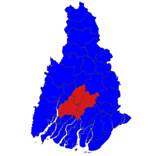
Myaungmya District (Burmese: မြောင်းမြခရိုင်) is a district of the Ayeyarwady Division in south western Myanmar. It consists of 5 cities. Myaungmya is the chief town of the district.
Myaungmya district was formed in 1893 out of a portion of Bassein district, and reconstituted until 1903. It has an area of 2,663 square miles (6,900 km2) and a population of 280,000 and density of 104 inhabitants to the square mile. The district is a deltaic tract, bordering south on the sea and traversed by many tidal creeks. Rice cultivation and fishing occupy practically all the inhabitants of the district.
The district contains three townships: Myaungmya Township, Einme Township, and Wakema Township. In the Townships, there are 50 wards, 489 village groups and 2557 villages.
16°30′N 95°00′E / 16.500°N 95.000°E / 16.500; 95.000
- v
- t
- e
Ayeyarwady Region
Capital: Pathein
- Hinthada Township
- Lemyethna Township
- Zalun Township


- Kyaunggon Township
- Kyonpyaw Township
- Yekyi Township (Ngathinechaung Subtownship)
- Labutta Township (Pyinsalu Subtownship)
- Mawlamyinegyun Township
- Pathein
- Ahmar
- Ahtaung
- Aingthapyu
- Bogale
- Chaungtha
- Danubyu
- Dedaye
- Einme
- Hainggyi Island
- Hinthada
- Ingapu
- Kanaung
- Kangyidaut
- Kyaiklat
- Kyangin
- Kyaunggon
- Kyonmanage
- Kyonpyaw
- Labutta
- Lemyethna
- Maubin
- Mawlamyinegyun
- Myan Aung
- Myaungmya
- Ngapudaw
- Ngathaingchaung
- Ngayokaung
- Ngwesaung
- Nyaungdon
- Pantanaw
- Pyapon
- Pyinsalu
- Shwelaung
- Thabaung
- Wakema
- Yekyi
- Zalun
  | This Ayeyarwady Region location article is a stub. You can help Wikipedia by expanding it. |
- v
- t
- e


