Mount Sheridan
Mountain in Wyoming, United States


Mount Sheridan
Yellowstone National Park, Teton County, Wyoming, U.S.
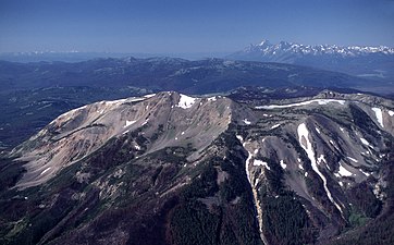
Mount Sheridan, elevation 10,313 feet (3,143 m), is a prominent mountain peak overlooking Heart Lake in the Red Mountains of Yellowstone National Park. The peak is named in honor of General Philip H. Sheridan, U.S. Army, one of the early protectors of the park.[2]
History
Members of the Washburn–Langford–Doane Expedition in 1870 gave this mountain the name of Brown Mountain, while Lt. Gustavus C. Doane, also a member of the expedition named the mountain Yellow Mountain. In 1871 during the Hayden Geological Survey of 1871 Ferdinand Vandeveer Hayden named the peak Red Mountain. Also in 1871, Captain John W. Barlow, a military member of the Hayden expedition ascended the peak on August 10, 1871 and named it Mount Sheridan to honor the general.[2] Years later the name Red Mountain was given to the entire range in which Mount Sheridan sits.
Opposite the head of this arm [South Arm of Yellowstone Lake] is the great yellow mountain seen from Mount Langford several days ago. This is the central point from which radiate double barriers, separating the waters of the Yellowstone from the Snake, and the latter from the Madison, Snake River flowing on the east side of the mountain southerly, and the Firehole branch of the Madison rising in a small lake to the west of the range, the main branch coming from Henry's Lake, south of this. This mountain may be said to be the focus of volcanic action in the basin, the greatest phenomena being observed within a radius of thirty miles from its summit. From its yellow, sulphureted appearance it can be readily distinguished, and is the central and most important landmark in the great basin.
— Gustavus C. Doane, September 11, 1870[3]
Mount Sheridan Trail
The summit can be reached via the Mount Sheridan Trail 3.9 miles (6.3 km) which spurs off the Heart Lake Trail at the northwest corner of Heart Lake. This is a steep climb of 3,000 feet (910 m) in 3 miles (4.8 km), but provides extraordinary views of the park in all directions and the Teton Range to the southwest.[4]
-
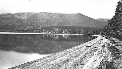 Heart Lake and Mountain Sheridan, 1878, William Henry Jackson
 -
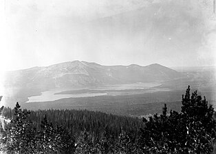 Heart Lake and Mount Sheridan, ca1890
 -
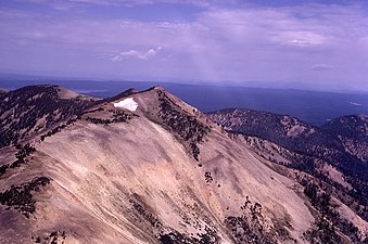 Mount Sheridan from the southeast, 1973
 -
 Mount Sheridan and Tetons, 1989
 -
 From West Thumb, Yellowstone Lake, June 2011


See also
Notes
- ^ a b "Mount Sheridan". Geographic Names Information System. United States Geological Survey, United States Department of the Interior.
- ^ a b Whittlesey, Lee (1988). Yellowstone Place Names. Helena, MT: Montana Historical Society Press. p. 107. ISBN 0-917298-15-2.
- ^ Doane, Gustavus C. (March 3, 1871). The report of Lieutenant Gustavus C. Doane upon the so-called Yellowstone Expedition of 1870 (Report). U.S. Secretary of War.
- ^ Schneider, Bill (2003). Hiking Yellowstone National Park. Guilford, CT: Falcon Press. pp. 328–330. ISBN 0-7627-2539-7.
- v
- t
- e
- Abiathar Peak
- Atkins Peak
- Barronette Peak
- Breccia Peak
- Clayton Mountain
- Colter Peak
- Druid Peak
- Eagle Peak
- Fortress Mountain
- Francs Peak
- Index Peak
- Mount Chittenden
- First Peoples Mountain
- Mount Hornaday
- Mount Langford
- Mount Norris
- Mount Schurz
- Mount Stevenson
- Pilot Peak
- Sheep Mesa
- The Thunderer
- Washakie Needles
- Younts Peak
| Bear Lodge Mountains | |
|---|---|
| Others |
- Antler Peak
- Bannock Peak
- Bunsen Peak
- Clagett Butte
- Dome Mountain (Park County)
- Echo Peak
- Gray Peak
- Joseph Peak
- Mount Everts
- Mount Haynes
- Mount Holmes
- Mount Jackson
- Purple Mountain
- Quadrant Mountain
- Sepulcher Mountain
- Terrace Mountain
- Three Rivers Peak
- Trilobite Point
- White Peaks
- Darwin Peak
- Doubletop Peak
- Sheep Mountain
- Elk Mountain (Carbon County)
- Medicine Bow Peak
- Albright Peak
- Battleship Mountain
- Bivouac Peak
- Buck Mountain
- Cathedral Group
- Cleaver Peak
- Cloudveil Dome
- Disappointment Peak
- Doane Peak
- Dry Ridge Mountain
- Eagles Rest Peak
- Elk Mountain (Teton County)
- Forellen Peak
- Fossil Mountain
- Grand Teton
- Green Lakes Mountain
- Housetop Mountain
- The Jaw
- Littles Peak
- Maidenform Peak
- Middle Teton
- Moose Mountain
- Mount Bannon
- Mount Glory
- Mount Hunt
- Mount Jedediah Smith
- Mount Meek
- Mount Moran
- Mount Owen
- Mount Saint John
- Mount Wister
- Mount Woodring
- Mount Woodrow Wilson
- Nez Perce Peak
- Owl Peak
- Prospectors Mountain
- Rammell Mountain
- Ranger Peak
- Raynolds Peak
- Red Mountain
- Rendezvous Mountain
- Rendezvous Peak
- Rock of Ages
- Rockchuck Peak
- Rolling Thunder Mountain
- Shadow Peak
- South Teton
- Spearhead Peak
- Static Peak
- Survey Peak
- Symmetry Spire
- Table Mountain
- Teepe Pillar
- Teewinot Mountain
- Temple Peak
- Thor Peak
- Traverse Peak
- Veiled Peak
- The Wall
- Window Peak
- American Legion Peak
- Atlantic Peak
- Bair Peak
- Bastion Peak
- Bastion Peak-Northeast Peak
- Bears Ears Mountain
- Big Sandy Mountain
- Block Tower
- Bow Mountain
- Brown Cliffs North
- Cathedral Peak
- Desolation Peak
- Dog Tooth Peak
- Dome Mountain (Hot Springs County)
- Doublet Peak
- Downs Mountain
- East Temple Peak
- Flagstone Peak (Fremont County)
- Fremont Peak
- Gannett Peak
- Harrower Peak
- Henderson Peak
- Jackson Peak
- Klondike Peak
- Knife Point Mountain
- Lander Peak
- Lizard Head Peak
- Mitchell Peak
- Mount Bonneville
- Mount Chauvenet
- Mount Febbas
- Mount Helen
- Mount Hooker
- Mount Koven
- Mount Lander
- Mount Nystrom
- Mount Owen
- Mount Sacagawea
- Mount Warren
- Mount Washakie
- Mount Whitecap
- Overhanging Tower
- Payson Peak
- Pingora Peak
- Pylon Peak
- Raid Peak
- Rampart Peak
- Roaring Fork Mountain
- Roberts Mountain
- Shale Mountain
- Sharks Nose
- South Downs Mountain
- The Sphinx
- Split Mountain
- Sunbeam Peak
- Three Waters Mountain
- Torrey Peak
- Turret Peak
- Twin Peaks
- Union Peak
- Valentine Mountain
- Valentine Peak
- War Bonnet Peak
- Warrior Peaks
- Watch Tower
- Whiskey Mountain
- Wind River Peak
- Wolfs Head
- Amethyst Mountain
- Aspen Mountain
- Barlow Peak
- Bridger Mountains
- Cook Peak
- Copper Mountain
- Dirty Mountain
- Douglas Knob
- Dunraven Peak
- Factory Hill
- Ferris Mountains
- Folsom Peak
- Garfield Peak
- Granite Mountains
- Granite Peak
- Heart Mountain
- Hedges Peak
- Hoyt Peak
- Jelm Mountain
- Mansface Hill
- Mount Hancock
- Mount Leidy
- Mount Sheridan
- Mount Washburn
- National Park Mountain
- Owl Creek Mountains
- Prospect Peak (Park County)
- Rawhide Buttes
- Roaring Mountain
- Sierra Madre Range
- Signal Mountain
- Snake River Range
- Specimen Ridge
- Sublette Mountain
- Tongue Butte
- Trischman Knob
- White Mountain
- Wilkins Peak
Yellowstone National Park – lake and environs | ||
|---|---|---|
Historic structures and other attractions in the Yellowstone Lake, West Thumb, South and East Entrance areas | ||
| Structures and history |  | |
| West Thumb Geyser Basin | ||
| Geography and geology |
| |


