Montefiore Conca
You can help expand this article with text translated from the corresponding article in Italian. (January 2022) Click [show] for important translation instructions.
- Machine translation, like DeepL or Google Translate, is a useful starting point for translations, but translators must revise errors as necessary and confirm that the translation is accurate, rather than simply copy-pasting machine-translated text into the English Wikipedia.
- Do not translate text that appears unreliable or low-quality. If possible, verify the text with references provided in the foreign-language article.
- You must provide copyright attribution in the edit summary accompanying your translation by providing an interlanguage link to the source of your translation. A model attribution edit summary is
Content in this edit is translated from the existing Italian Wikipedia article at [[:it:Montefiore Conca]]; see its history for attribution. - You may also add the template
{{Translated|it|Montefiore Conca}}to the talk page. - For more guidance, see Wikipedia:Translation.
Comune in Emilia-Romagna, Italy
Montefiore Conca | |
|---|---|
Comune | |
| Comune di Montefiore Conca | |
 | |
Location of Montefiore Conca  | |
43°53′N 12°37′E / 43.883°N 12.617°E / 43.883; 12.617 | |
| Country | Italy |
| Region | Emilia-Romagna |
| Province | Rimini (RN) |
| Frazioni | Borgo Pedrosa, La Falda, Levola, San Felice, San Gaudenzio, Serbadone, Serra di Sopra, Serra di Sotto |
| Government | |
| • Mayor | Filippo Sica |
| Area | |
| • Total | 22.32 km2 (8.62 sq mi) |
| Elevation | 385 m (1,263 ft) |
| Population (31 October 2020)[2] | |
| • Total | 2,217 |
| • Density | 99/km2 (260/sq mi) |
| Demonym | Montefioresi |
| Time zone | UTC+1 (CET) |
| • Summer (DST) | UTC+2 (CEST) |
| Postal code | 47834 |
| Dialing code | 0541 |
| Website | Official website |
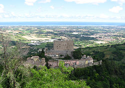
Montefiore Conca (Romagnol: Munt Fior) is a comune (municipality) in the Province of Rimini in the Italian region Emilia-Romagna, located about 120 kilometres (75 mi) southeast of Bologna and about 20 kilometres (12 mi) south of Rimini.
Montefiore Conca borders the following municipalities: Gemmano, Mondaino, Morciano di Romagna, Saludecio, San Clemente, Sassocorvaro Auditore, Tavoleto. It is one of I Borghi più belli d'Italia ("The most beautiful villages of Italy").[3]
References
- v
- t
- e
- Bellaria – Igea Marina
- Casteldelci
- Cattolica
- Coriano
- Gemmano
- Maiolo
- Misano Adriatico
- Mondaino
- Montecopiolo
- Montefiore Conca
- Montegridolfo
- Montescudo-Monte Colombo
- Morciano di Romagna
- Novafeltria
- Pennabilli
- Poggio Torriana
- Riccione
- Rimini
- Saludecio
- San Clemente
- San Giovanni in Marignano
- San Leo
- Sant'Agata Feltria
- Santarcangelo di Romagna
- Sassofeltrio
- Talamello
- Verucchio
| Authority control databases |
|
|---|
 | This article on a location in Emilia–Romagna is a stub. You can help Wikipedia by expanding it. |
- v
- t
- e


