Mojuí dos Campos
You can help expand this article with text translated from the corresponding article in Portuguese. (April 2022) Click [show] for important translation instructions.
- Machine translation, like DeepL or Google Translate, is a useful starting point for translations, but translators must revise errors as necessary and confirm that the translation is accurate, rather than simply copy-pasting machine-translated text into the English Wikipedia.
- Consider adding a topic to this template: there are already 1,531 articles in the main category, and specifying
|topic=will aid in categorization. - Do not translate text that appears unreliable or low-quality. If possible, verify the text with references provided in the foreign-language article.
- You must provide copyright attribution in the edit summary accompanying your translation by providing an interlanguage link to the source of your translation. A model attribution edit summary is
Content in this edit is translated from the existing Portuguese Wikipedia article at [[:pt:Mojuí dos Campos]]; see its history for attribution. - You may also add the template
{{Translated|pt|Mojuí dos Campos}}to the talk page. - For more guidance, see Wikipedia:Translation.
Place in Norte, Brazil

Flag
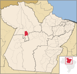
Location of the Mojuí dos Campos
(2020 [1])
Mojuí dos Campos is a municipality in the state of Pará in the Northern region of Brazil. The city had already emancipated from Santarém in 1999, but since that date no municipal elections were run in the city until the 2012 one.[2] Consequently, the city was established on January 1, 2013, with the inauguration of the city's first mayor and councilors.[3]
See also
References
2°41′5″S 54°38′25″W / 2.68472°S 54.64028°W / -2.68472; -54.64028
- v
- t
- e

Capital: Belém
Lower Amazonas
| Almeirim | |
|---|---|
| Óbidos | |
| Santarém |

Marajó
| Arari | |
|---|---|
| Furos de Breves | |
| Portel |
Metropolitan Belém
| Belém | |
|---|---|
| Castanhal |
Northeastern Pará
| Bragantina | |
|---|---|
| Cametá | |
| Guamá | |
| Salgado | |
| Tomé-Açu |
Southeastern Pará
| Conceição do Araguaia | |
|---|---|
| Marabá | |
| Paragominas | |
| Parauapebas | |
| Redenção | |
| São Félix do Xingu | |
| Tucurui |
Southwestern Pará
| Altamira | |
|---|---|
| Itaituba |
 | This Pará, Brazil location article is a stub. You can help Wikipedia by expanding it. |
- v
- t
- e


