List of Pittsburgh neighborhoods
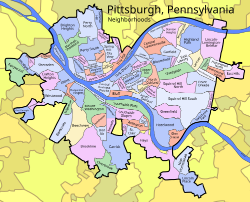
This is a list of 90 neighborhoods in the city of Pittsburgh, Pennsylvania, United States. Generally neighborhood development followed ward boundaries, although the City Planning Commission has defined some neighborhood areas.[1] The map of neighborhoods presented here is based on the official designations from the City of Pittsburgh.[2]
Neighborhoods
- Allegheny Center
- Allegheny West
- Allentown
- Arlington
- Arlington Heights
- Banksville
- Bedford Dwellings
- Beechview
- Beltzhoover
- Bloomfield
- Bluff (also known as Uptown or Soho)
- Bon Air
- Brighton Heights
- Brookline
- California-Kirkbride
- Carrick
- Central Business District (also known as Downtown and the Golden Triangle)
- Chinatown (historic)
- Cultural District
- Central Lawrenceville
- Central Northside
- Mexican War Streets
- Central Oakland
- Chartiers
- Chateau
- Crafton Heights
- Crawford-Roberts
- Duquesne Heights
- East Allegheny (also known as Deutschtown)
- East Carnegie
- East Hills
- East Liberty
- Elliott
- Esplen
- Fairywood
- Fineview
- Friendship
- Garfield
- The Valley
- Hilltop
- Glen Hazel
- Greenfield
- Four Mile Run
- Hays
- Hazelwood
- Highland Park
- Homewood North
- Homewood South
- Homewood West
- Knoxville
- Larimer
- Lincoln–Lemington–Belmar
- Lincoln Place
- Lower Lawrenceville
- Manchester
- Marshall-Shadeland (also known as Brightwood and Woods Run)
- Brunot Island
- Middle Hill
- Morningside
- Mount Oliver (not to be confused with the neighboring borough of Mount Oliver)
- Mount Washington
- Chatham Village
- New Homestead
- North Oakland
- North Point Breeze
- North Shore
- Northview Heights
- Oakwood
- Overbrook
- Perry North (also known as Observatory Hill)
- Perry South (also known as Perry Hilltop)
- Point Breeze
- Park Place
- Polish Hill
- Regent Square
- Ridgemont
- Saint Clair
- Shadyside
- Sheraden
- South Oakland
- Panther Hollow
- South Shore
- South Side Flats
- South Side Slopes
- Spring Garden
- Spring Hill–City View
- Squirrel Hill North
- Squirrel Hill South
- Stanton Heights
- Strip District
- Summer Hill
- Swisshelm Park
- Terrace Village
- Troy Hill
- Upper Hill
- Upper Lawrenceville
- West End
- West Oakland
- Westwood
- Windgap
Areas
List of municipalities annexed
- Pitt Township (part) in 1816
- Northern Liberties in 1837
- Lawrenceville in 1867
- Collins, Liberty, Oakland, Peebles and Pitt Twps. in 1868
- Allentown, Birmingham, East Birmingham, Monongahela, Mount Washington, Ormsby, South Pittsburgh, St. Clair, Temperanceville, Union and West Pittsburgh in 1872
- Garfield in 1881
- Brushton in 1894
- Beltzhoover in 1898
- Esplen and Sterrett Twp. in 1906
- Allegheny in 1907, including formerly-annexed Manchester (1867) and Duquesne (part, 1868)
- Beechview and West Liberty in 1908
- Spring Garden in 1920
- Lower St. Clair Township in 1924
- Carrick, Knoxville, and Westwood in 1927
- Overbrook in 1930
See also
- History of Pittsburgh
- North Hills (Pennsylvania)
- Penn Hills, Pennsylvania
- Pittsburgh areas
- Pittsburgh metropolitan area communities
- South Hills (Pennsylvania)
References
Wikimedia Commons has media related to Neighborhoods in Pittsburgh.
- ^ Jones, Diana N. (June 5, 2006). "Defining city neighborhoods an imprecise process". Pittsburgh Post-Gazette. Retrieved December 7, 2009.
- ^ "Geographic Information Systems - Pittsburgh Map Room". City of Pittsburgh. Retrieved September 16, 2014.
- ^ "The Growth of Pittsburgh: Annexation and Population".
| ||
|---|---|---|
| Government |  | |
| Economy | ||
| Other topics | ||
| ||


