Lewis and Clark State Historic Site
Historic site in Illinois
| Lewis and Clark State Historic Site | |
|---|---|
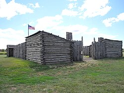 A reconstruction of Camp Dubois is on the grounds of the historic site. | |
 | |
The Lewis and Clark State Historic Site opened in 2002 and is owned and operated by the Illinois Department of Natural Resources Division of Historic Preservation (formerly Illinois Historic Preservation Agency). The site, located in Hartford, Illinois, commemorates Camp River Dubois, the camp of the Lewis and Clark Expedition from December 1803 to May 1804. The site is National Trail Site #1 on the Lewis and Clark National Historic Trail and is located directly off the Confluence Bike Trail, part of the Confluence Greenway. The site is at the southern end of the Meeting of the Great Rivers Scenic Route.
The Lewis and Clark State Historic Site is situated on the dry side of the Chain of Rocks Levee, approximately 0.25 miles (0.40 km) from the Illinois shore of the Mississippi River. It is also known as Lewis and Clark State Park.
Main attractions at the site include a 14,000-square-foot (1,300 m2) interpretive center and an outdoor replica of Camp River Dubois.[1] The interpretive center contains a theater, multiple hands-on exhibits and displays, and a 55-foot (17 m) full-scale cutaway keelboat.
References
- ^ "Lewis & Clark State Historic Site | The Point of Departure". Retrieved 2022-03-28.
External links
Wikimedia Commons has media related to Lewis and Clark State Historic Site (Illinois).
- Lewis and Clark State Historic Site — official website
- v
- t
- e
| National Historic Sites and Parks and national monument | |
|---|---|
| National Forest |
|
| National Wildlife Refuges | |
| National Grassland | |
| National Trails/National Heritage Area | |
| National Natural Landmarks | |
| National Wild and Scenic Rivers | |
| Wetlands of international importance |
|
| County Districts |
|---|
 Category
- Chicago
- East St. Louis
- Illinois Department of Natural Resources
 Commons


| ||
|---|---|---|
| Topics |  | |
| Central city | ||
| Largest cities (over 50,000 in 2020) | ||
| Medium-sized cities (over 20,000 in 2020) | ||
| Largest towns and villages (over 10,000 in 2020) |
| |
| Missouri counties | ||
| Illinois counties | ||
| Subregions | ||
38°48′08″N 90°06′08″W / 38.8023°N 90.1021°W / 38.8023; -90.1021
 | This Illinois museum-related article is a stub. You can help Wikipedia by expanding it. |
- v
- t
- e


