Leegebruch
Municipality in Brandenburg, Germany

Coat of arms
Location of Leegebruch within Oberhavel district

(2022-12-31)[2]
16767


Leegebruch is a municipality in the Oberhavel district, in Brandenburg, Germany.
Demography
-
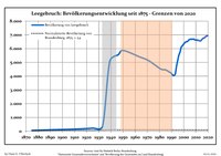 Development of Population since 1875 within the Current Boundaries (Blue Line: Population; Dotted Line: Comparison to Population Development of Brandenburg state; Grey Background: Time of Nazi rule; Red Background: Time of Communist rule))
 -
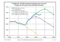 Recent Population Development and Projections (Population Development before Census 2011 (blue line); Recent Population Development according to the Census in Germany in 2011 (blue bordered line); Official projections for 2005-2030 (yellow line); for 2014-2030 (red line); for 2017-2030 (scarlet line)


|
|
|
References
- ^ Landkreis Oberhavel Wahl der Bürgermeisterin / des Bürgermeisters, accessed 2 July 2021.
- ^ "Bevölkerungsentwicklung und Bevölkerungsstandim Land Brandenburg Dezember 2022" (PDF). Amt für Statistik Berlin-Brandenburg (in German). June 2023.
- ^ Detailed data sources are to be found in the Wikimedia Commons.Population Projection Brandenburg at Wikimedia Commons
- v
- t
- e
Towns and municipalities in Oberhavel
- Birkenwerder
- Fürstenberg/Havel
- Glienicke/Nordbahn
- Gransee
- Großwoltersdorf
- Hennigsdorf
- Hohen Neuendorf
- Kremmen
- Leegebruch
- Liebenwalde
- Löwenberger Land
- Mühlenbecker Land
- Oberkrämer
- Oranienburg
- Schönermark
- Sonnenberg
- Stechlin
- Velten
- Zehdenick

Authority control databases | |
|---|---|
| International |
|
| National |
|
| Geographic |
|
 | This Brandenburg location article is a stub. You can help Wikipedia by expanding it. |
- v
- t
- e


