Ketzin
Town in The Havelland Located in Brandenburg Germany
Coat of arms

Ketzin In Germany

Ketzin In Havelland (district)
Ketzin (German: [kɛˈt͡siːn] ⓘ, official name: Ketzin/Havel) is a town in the Havelland district, in Brandenburg, Germany. It is situated on the river Havel, 17 km northwest of Potsdam, and 40 km west of Berlin.
History
Demography
-
 Development of Population since 1875 within the Current Boundaries (Blue Line: Population; Dotted Line: Comparison to Population Development of Brandenburg state; Grey Background: Time of Nazi rule; Red Background: Time of Communist rule)
 -
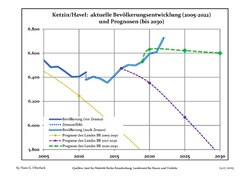 Recent Population Development and Projections (Population Development before Census 2011 (blue line); Recent Population Development according to the Census in Germany in 2011 (blue bordered line); Official projections for 2005-2030 (yellow line); for 2017-2030 (scarlet line); for 2020-2030 (green line)


|
|
|
Geography
The town counts 6 Ortsteile (civil parishes): Etzin, Falkenrehde, Knoblauch, Paretz, Tremmen and Zachow.
Transport
The Ketzin Cable Ferry, a vehicular cable ferry, crosses the Havel between Ketzin and Schmergow.
References
- ^ Detailed data sources are to be found in the Wikimedia Commons.Population Projection Brandenburg at Wikimedia Commons
External links
![]() Media related to Ketzin/Havel at Wikimedia Commons
Media related to Ketzin/Havel at Wikimedia Commons
- v
- t
- e
Towns and municipalities in Havelland
- Brieselang
- Dallgow-Döberitz
- Falkensee
- Friesack
- Gollenberg
- Großderschau
- Havelaue
- Ketzin
- Kleßen-Görne
- Kotzen
- Märkisch Luch
- Milower Land
- Mühlenberge
- Nauen
- Nennhausen
- Paulinenaue
- Pessin
- Premnitz
- Rathenow
- Retzow
- Rhinow
- Schönwalde-Glien
- Seeblick
- Stechow-Ferchesar
- Wiesenaue
- Wustermark

Authority control databases | |
|---|---|
| International |
|
| National |
|
| Geographic |
|
 | This Brandenburg location article is a stub. You can help Wikipedia by expanding it. |
- v
- t
- e


