Keane Bridge
Bridge in Bangladesh
24°53′15″N 91°52′05″E / 24.8876°N 91.8681°E / 24.8876; 91.8681

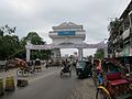
The Keane Bridge is a notable landmark of Sylhet city, Bangladesh.[1] This bridge is called the gateway to Sylhet city.
After Earl Robert Miller, the ambassador of USA to Bangladesh visited the bridge and recommended its sole use as a pedestrian bridge, no vehicles are allowed to drive through the bridge. It is therefore the longest footover bridge in Bangladesh.[2]
Location and description

This bridge is located over the Surma River at the middle of Sylhet city which is 246 kilometres (153 mi) northeast of Dhaka, the capital of Bangladesh.
History
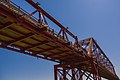
This bridge was built in 1936 and is named after Sir Michael Keane who was the English Governor of Assam from 1932 to 1937.[3]
Structure
It is made of iron and steel and looks like a bow. The bridge is 1150 feet long and 18 feet breadth. About Taka 5.6 million was spent to build the bridge.[4]
Damage and repair
During the Bangladesh Liberation War the bridge was blown off with dynamite by the Pakistan Army and damaged. It was repaired in 1977.[5]
Gallery
-
 North entrance
 -

-
 From south
 -
 Keane Bridge views at night
 -
- Night View Of Keane Bridge


References
- ^ "Keane Bridge on Surma River: heritage of Sylhet". Daily Asian Age. Dhaka. 20 December 2016. Retrieved 18 August 2019.
- ^ "কিন ব্রিজে এখন শুধু জনতার পথচলা" (in Bengali). Kaler Kantho. 3 September 2019.
- ^ "Keane Bridge Sylhet". Yogsutra.com. Retrieved 8 December 2012.
- ^ "Welcome to Kean Bridge - Sylhet, Bangladesh". Tourtobangladesh.com. Retrieved 8 December 2012.
- ^ "Sylhet's Keane Bridge". The Sylhet Times. 11 October 2008. Archived from the original on 5 October 2012. Retrieved 8 December 2012.
External links
Wikimedia Commons has media related to Keane Bridge.
- v
- t
- e
Sylhet District
Capital: Sylhet
- Balaganj
- Beanibazar
- Bishwanath
- Companiganj
- Fenchuganj
- Golapganj
- Gowainghat
- Jaintiapur
- Kanaighat
- Osmani Nagar
- South Surma
- Sylhet Sadar
- Zakiganj

- The Aided High School
- Beani Bazar Government College
- Blue Bird High School and College
- Cambridge Grammar School & College
- Dhakadakshin Multilateral High School and College
- Kasim Ali Model High School
- Madan Mohan College
- Mathiura BL High School
- Murari Chand College
- Scholarshome
- Sylhet Engineering College
- Sylhet Government Pilot High School
- Sylhet Government Women's College
- Sylhet Polytechnic Institute
24°53′15″N 91°52′05″E / 24.8876°N 91.8681°E / 24.8876; 91.8681
  | This article about a bridge in Bangladesh is a stub. You can help Wikipedia by expanding it. |
- v
- t
- e


