Juruá, Amazonas
Municipality in North, Brazil
Flag
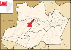
Location of the municipality inside Amazonas
 Brazil
 (2020)
Juruá is a municipality located in the Brazilian state of Amazonas. Its population was 15,106 (2020)[1] and its area is 19,400 km².[2]
The municipality contains 62% of the 187,982 hectares (464,510 acres) Baixo Juruá Extractive Reserve, created in 2001.[3] The municipality contains about 12% of the Tefé National Forest, created in 1989.[4]
References
- ^ IBGE 2020
- ^ IBGE - "Archived copy". Archived from the original on 2008-06-11. Retrieved 2014-08-03.
{{cite web}}: CS1 maint: archived copy as title (link) - ^ RESEX do Baixo Juruá (in Portuguese), ISA: Instituto Socioambiental, retrieved 2016-10-22
- ^ FLONA de Tefé (in Portuguese), ISA: Instituto Socioambiental, retrieved 2016-10-19
- v
- t
- e
Capital: Manaus
Centro Amazonense
| Coari |
|
|---|---|
| Itacoatiara | |
| Manaus | |
| Parintins | |
| Rio Preto da Eva | |
| Tefe |

Norte Amazonense
| Japura | |
|---|---|
| Rio Negro |
Sudoeste Amazonense
| Alto Solimoes | |
|---|---|
| Jurua |
Sul Amazonense
| Boca do Acre | |
|---|---|
| Madeira | |
| Purus |
 | This article about a location in the Brazilian state of Amazonas is a stub. You can help Wikipedia by expanding it. |
- v
- t
- e


