Hopton, Suffolk
Human settlement in England
- West Suffolk
- Suffolk
- East
- West Suffolk
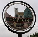
Hopton is a village and civil parish in the West Suffolk district of Suffolk in eastern England. Located just south of the Norfolk border on the B1111 road between Stanton and Garboldisham, in 2011 it had a population of 653. It shares a parish council with neighbouring Knettishall.
All Saints' Church is at the geographical centre of the village, it has regular services and is part of the United Benefice of Stanton, Hopton, Market Weston, Barningham & Coney Weston.[2]
Schools
There is a primary school, and a pre-school. The primary school feeds students both to Thurston Community College in Thurston and Ixworth Free School in Ixworth.
References
External links
![]() Media related to Hopton, Suffolk at Wikimedia Commons
Media related to Hopton, Suffolk at Wikimedia Commons
- Hopton cum Knettishall Parish Council
- Hopton Primary School
- v
- t
- e
- Ampton
- Bardwell
- Barnardiston
- Barnham
- Barningham
- Barrow
- Barton Mills
- Beck Row, Holywell Row and Kenny Hill
- Bradfield Combust with Stanningfield
- Bradfield St Clare
- Bradfield St George
- Brockley
- Cavendish
- Cavenham
- Chedburgh
- Chevington
- Coney Weston
- Cowlinge
- Culford
- Dalham
- Denham
- Denston
- Depden
- Elveden
- Eriswell
- Euston
- Exning
- Fakenham Magna
- Flempton
- Fornham All Saints
- Fornham St Genevieve
- Fornham St Martin
- Freckenham
- Gazeley
- Great Barton
- Great Bradley
- Great Livermere
- Great Thurlow
- Great Whelnetham
- Great Wratting
- Hargrave
- Hawkedon
- Hawstead
- Hengrave
- Hepworth
- Herringswell
- Higham
- Honington
- Hopton
- Horringer
- Hundon
- Icklingham
- Ickworth
- Ingham
- Ixworth
- Ixworth Thorpe
- Kedington
- Kentford
- Knettishall
- Lackford
- Lakenheath
- Lidgate
- Little Bradley
- Little Livermere
- Little Thurlow
- Little Whelnetham
- Little Wratting
- Market Weston
- Moulton
- Nowton
- Ousden
- Pakenham
- Poslingford
- Rede
- Red Lodge
- Risby
- Rushbrooke with Rougham
- Santon Downham
- Sapiston
- Stansfield
- Stanton
- Stoke-by-Clare
- Stradishall
- Thelnetham
- The Saxhams
- Timworth
- Troston
- Tuddenham
- West Row
- Westley
- West Stow
- Whepstead
- Wickhambrook
- Withersfield
- Wixoe
- Wordwell
- Worlington
- Coldham Hall
- St Edmundsbury Cathedral
- St Mary's Church, Bury St Edmunds
- Northgate House
- Bury St Edmunds Guildhall
- Theatre Royal, Bury St Edmunds
- St Mary the Virgin's Church, Cavendish
- Clare Priory
- St Peter and St Paul's Church, Clare
- Ancient House, Clare
- Hengrave Hall
- All Saints' Church, Icklingham
- Ickworth House
- The Iron Bridge, Culford Park
- St Mary's Church, Mildenhall
- St Andrew's Church, Sapiston
- All Saints Church, Wordwell
- West Suffolk (UK Parliament constituency), South Suffolk (UK Parliament constituency), Bury St Edmunds (UK Parliament constituency)
- Local Elections
 | This Suffolk location article is a stub. You can help Wikipedia by expanding it. |
- v
- t
- e


