Hida River
River in Japan
| Hida River | |
|---|---|
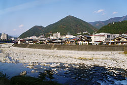 The Hida River flowing through Gero | |
| Native name | 飛騨川 (Japanese) |
| Location | |
| Country | Japan |
| Physical characteristics | |
| Source | |
| • location | Mount Norikura |
| • elevation | 3,026 m (9,928 ft) |
| Mouth | |
• location | Kiso River |
| Length | 148 km (92 mi) |
| Basin size | 2,170 km2 (840 sq mi) |
| Basin features | |
| River system | Kiso River |
The Hida River (飛騨川, Hida-gawa) has its source in Mount Norikura (乗鞍岳 Norikura-ga-take) in Takayama, Gifu Prefecture, Japan. It flows from the northern to the southern section of the prefecture before emptying into the Kiso River in Minokamo.
River communities
The river passes through or forms the boundary of the communities listed below.
- Gifu Prefecture
- Takayama, Gero, Shirakawa (Ōno District), Yaotsu, Hichisō, Kawabe, Minokamo
References
External links
35°26′46″N 137°03′09″E / 35.446241°N 137.052444°E / 35.446241; 137.052444 (mouth)
- v
- t
- e

Rivers of Hokkaido | |||||||||
|---|---|---|---|---|---|---|---|---|---|
| |||||||||
Rivers of Honshu | |
|---|---|
Rivers of Shikoku | |||
|---|---|---|---|
|
Rivers of Kyushu | |||||
|---|---|---|---|---|---|
| |||||
 Rivers of Japan Category
 Rivers of Japan on Commons

Authority control databases | |
|---|---|
| International |
|
| National |
|
 | This Gifu Prefecture location article is a stub. You can help Wikipedia by expanding it. |
- v
- t
- e
 | This article related to a river in Japan is a stub. You can help Wikipedia by expanding it. |
- v
- t
- e


