Harlebucht
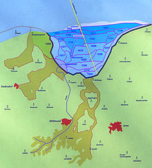
The Harlebucht or Harle Bay was originally a bay approximately 15 kilometers wide that reached about 10 kilometers inland north of Wittmund in today's East Frisia. (A more appropriate translation of bucht here might be Bight; the German word can mean either.)
The water encroachments into the hinterland in the Grote Mandrenke (Second Marcellus Flood) in 1362, which reached as far as the Geest near Jever, gave rise to side bays and greatly enlarged the Harlebucht. Around 1550 began a period of building dikes and polders, draining the Harlebucht and turning it into farmland.[1] Piece by piece, fertile farmland was created from what had been marsh and bay, until in 1894 the Elisabethgroden section was completed.
References
- ^ "Harlebucht und Goldene Linie". Nordwestreisemagazin. Retrieved 6 October 2012.
53°42′N 7°48′E / 53.700°N 7.800°E / 53.700; 7.800
Look up bight in Wiktionary, the free dictionary.
- v
- t
- e
Bays and former bays on the East Frisian Peninsula
- Dollart
- Bay of Campen
- Bay of Sielmönken
- Leybucht
- Hilgenried Bay
- Nessmer Bay
- Dornum Bay
- Harlebucht
- Crildum Bay
- Maadebucht
- Jade Bight
- Schwarzes Brack

 | This East Frisia article is a stub. You can help Wikipedia by expanding it. |
- v
- t
- e
 | This Lower Saxony location article is a stub. You can help Wikipedia by expanding it. |
- v
- t
- e


