Haastrecht
Town in South Holland, Netherlands

Flag

Coat of arms
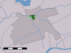
The town centre (dark green) and the statistical district (light green) of Haastrecht in the former municipality of Vlist.
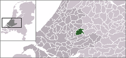
Haastrecht is a town on the Hollandse IJssel river in the Dutch province of South Holland. It is a part of the municipality of Krimpenerwaard, and lies about 5 km east of Gouda.
In 2001, the town of Haastrecht had 3302 inhabitants. The built-up area of the town was 0.58 km², and contained 1325 residences.[1] The statistical area "Haastrecht", which also can include the peripheral parts of the village, as well as the surrounding countryside, has a population of around 2330.[2]
Haastrecht received city rights in 1396. It remained a separate municipality until 1985, when it became part of Vlist.[3]
References
- ^ Statistics Netherlands (CBS), Bevolkingskernen in Nederland 2001 Archived 2007-01-24 at the Wayback Machine. (Statistics are for the continuous built-up area).
- ^ Statistics Netherlands (CBS), Statline: Kerncijfers wijken en buurten 2003-2005. As of 1 January 2005.
- ^ Ad van der Meer and Onno Boonstra, Repertorium van Nederlandse gemeenten, KNAW, 2011.
Wikimedia Commons has media related to Haastrecht.
Authority control databases | |
|---|---|
| International |
|
| National |
|
- v
- t
- e


