Grade I and II* listed buildings in the London Borough of Croydon
Map all coordinates using OpenStreetMap
Download coordinates as:
- KML
- GPX (all coordinates)
- GPX (primary coordinates)
- GPX (secondary coordinates)
There are over 9,000 Grade I listed buildings and 20,000 Grade II* listed buildings in England. This page is a list of these buildings in the London Borough of Croydon.
Grade I
| Name | Location | Type | Completed [note 1] | Date designated | Grid ref.[note 2] Geo-coordinates | Entry number [note 3] | Image |
|---|---|---|---|---|---|---|---|
| Church of All Saints | Sanderstead | Parish church | Late 13th century | 20 May 1954 | TQ3413861485 51°20′12″N 0°04′33″W / 51.33664°N 0.07577°W / 51.33664; -0.07577 (Church of All Saints) | 1079341 |  More images |
| Church of St John the Evangelist | Coulsdon | Church | 1250 | 20 May 1954 | TQ3127358187 51°18′28″N 0°07′05″W / 51.307669°N 0.118088°W / 51.307669; -0.118088 (Church of St John the Evangelist) | 1188464 | 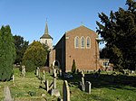 More images |
| Church of St Mary Addington | Croydon | Church | 1080 | 29 January 1951 | TQ3710463991 51°21′30″N 0°01′56″W / 51.358453°N 0.032254°W / 51.358453; -0.032254 (Church of St Mary Addington) | 1079343 |  More images |
| Hospital of the Holy Trinity (Whitgift Hospital) | Croydon | Almshouses | 1599 | 29 January 1951 | TQ3232565584 51°22′26″N 0°06′01″W / 51.373901°N 0.100258°W / 51.373901; -0.100258 (Hospital of the Holy Trinity (Whitgift Hospital)) | 1188846 |  More images |
| Old Palace School (Croydon Palace) | Croydon | Archbishop's palace | 15th century | 29 January 1951 | TQ3197065392 51°22′20″N 0°06′20″W / 51.372258°N 0.105427°W / 51.372258; -0.105427 (Old Palace School (Croydon Palace)) | 1079296 |  More images |
| Parish Church of St John the Baptist | Croydon | Parish church | 15th century | 29 January 1951 | TQ3193665440 51°22′22″N 0°06′21″W / 51.372697°N 0.105897°W / 51.372697; -0.105897 (Parish Church of St John the Baptist) | 1079319 |  More images |
| Parish Church of St Michael and All Angels | Croydon | Parish church | 1880–85 | 20 May 1954 | TQ3226366068 51°22′42″N 0°06′03″W / 51.378265°N 0.100968°W / 51.378265; -0.100968 (Parish Church of St Michael and All Angels) | 1079297 |  More images |
Grade II*
| Name | Location | Type | Completed [note 1] | Date designated | Grid ref.[note 2] Geo-coordinates | Entry number [note 3] | Image |
|---|---|---|---|---|---|---|---|
| Addington Palace (Royal School of Church Music) | Croydon | House | 1772 | 29 January 1951 | TQ3636963609 51°21′19″N 0°02′35″W / 51.355197°N 0.04295°W / 51.355197; -0.04295 (Addington Palace (Royal School of Church Music)) | 1358819 |  More images |
| Airport House | Croydon | Airport terminal | 1928 | 1 August 1978 | TQ3116663615 51°21′23″N 0°07′03″W / 51.356474°N 0.11762828°W / 51.356474; -0.11762828 (Airport House) | 1188970 |  More images |
| Church of St Augustine | Croydon | Church | 1881–84 | 29 October 1976 | TQ3242463237 51°21′10″N 0°05′59″W / 51.352786°N 0.09971°W / 51.352786; -0.09971 (Church of St Augustine) | 1079301 | 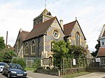 More images |
| Church of St James | Croydon | Church | 1829 | 29 October 1976 | TQ3266766451 51°22′54″N 0°05′42″W / 51.381613°N 0.095024°W / 51.381613; -0.095024 (Church of St James) | 1294484 |  More images |
| St John the Evangelist | Upper Norwood | Church | 1878–87 | 29 October 1976 | TQ3360969805 51°24′42″N 0°04′49″W / 51.411533°N 0.080235°W / 51.411533; -0.080235 (St John the Evangelist) | 1079275 |  More images |
| Church of St Mary Magdalene | Addiscombe | Church | 1868 | 29 October 1976 | TQ3353166011 51°22′39″N 0°04′58″W / 51.377456°N 0.082782°W / 51.377456; -0.082782 (Church of St Mary Magdalene) | 1358794 | 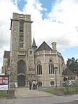 More images |
| Church of the Holy Innocents, and boundary wall | Croydon | Church | 1894–95 | 29 November 1976 | TQ3369768196 51°23′49″N 0°04′46″W / 51.397053°N 0.079576°W / 51.397053; -0.079576 (Church of the Holy Innocents, and boundary wall) | 1079303 |  More images |
| Wrencote House | Croydon | House | Late 17th century | 29 January 1951 | TQ3238265149 51°22′12″N 0°05′59″W / 51.369978°N 0.099602°W / 51.369978; -0.099602 (Wrencote House) | 1079291 |  More images |
| Croydon War Memorial | Croydon | War memorial | 1921 | 19 November 1973 | TQ3239265405 51°22′20″N 0°05′58″W / 51.372277°N 0.099362791°W / 51.372277; -0.099362791 (Croydon War Memorial) | 1268438 |  More images |
Notes
- ^ a b The date given is the date used by Historic England as significant for the initial building or that of an important part in the structure's description.
- ^ a b Sometimes known as OSGB36, the grid reference is based on the British national grid reference system used by the Ordnance Survey.
- ^ a b The "List Entry Number" is a unique number assigned to each listed building and scheduled monument by Historic England.
External links
 Media related to Grade I listed buildings in the London Borough of Croydon at Wikimedia Commons
- Media related to Grade II* listed buildings in the London Borough of Croydon at Wikimedia Commons
- v
- t
- e
- Addington
- Addiscombe
- Beddington
- Broad Green
- Coombe
- Coulsdon
- Croydon
- Crystal Palace
- Forestdale
- Hamsey Green
- Kenley
- Monks Orchard
- New Addington
- Norbury
- Norwood New Town
- Old Coulsdon
- Old Town
- Pollards Hill
- Purley
- Russell Hill
- Sanderstead
- Selhurst
- Selsdon
- Shirley (Including Shirley Oaks and Upper Shirley)
- South Croydon
- South Norwood
- Spring Park
- Thornton Heath
- Upper Norwood
- Waddon
- Woodcote
- Woodside
- Whyteleafe


open spaces
- Addington Hills
- Addington Park
- Addington Vale
- Addiscombe Railway Park
- Addiscombe Recreation Ground
- Apsley Road Playground
- Ashburton Park
- Ashburton Playing Fields
- Beaulieu Heights
- Bramley Bank
- Brickfields Meadow
- Coombe Wood
- Cotelands
- Croham Hurst
- Duppas Hill
- Farthing Downs
- Foxley Wood
- Grangewood Park
- Great North Wood
- Happy Valley Park
- Heathfield House
- Heavers Meadow
- Hutchinson's Bank
- Kenley Common
- Littleheath Woods
- Lloyd Park
- Mitcham Common
- Norwood Grove
- Park Hill
- Pollards Hill
- Queen's Gardens
- Riddlesdown Common
- Roundshaw
- Selsdon Wood
- South Norwood Country Park
- South Norwood Lake and Grounds
- South Norwood Recreation Ground
- Spa Wood
- Wandle Park
- Woodside Green
- Croydon South
- Croydon Central
- Croydon North
- Addiscombe East
- Addiscombe West
- Bensham Manor
- Broad Green
- Coulsdon Town
- Crystal Palace & Upper Norwood
- Fairfield
- Kenley
- New Addington North
- New Addington South
- Norbury & Pollards Hill
- Norbury Park
- Old Coulsdon
- Park Hill & Whitgift
- Purley & Woodcote
- Purley Oaks & Riddlesdown
- Sanderstead
- Selhurst
- Selsdon & Addington Village
- Selsdon Vale & Forestdale
- Shirley North
- Shirley South
- South Croydon
- South Norwood
- Thornton Heath
- Waddon
- West Thornton
- Woodside
and tram stops
- Addington Village
- Addiscombe
- Ampere Way
- Arena
- Blackhorse Lane
- Centrale
- Church Street
- Coombe Lane
- Coulsdon South
- Coulsdon Town
- East Croydon
- Fieldway
- George Street
- Gravel Hill
- Harrington Road
- Kenley
- King Henry's Drive
- Lebanon Road
- Lloyd Park
- New Addington
- Norbury
- Norwood Junction
- Purley Oaks
- Purley
- Reedham
- Reeves Corner
- Riddlesdown
- Sanderstead
- Sandilands
- Selhurst
- South Croydon
- Thornton Heath
- Waddon
- Waddon Marsh
- Wandle Park
- Wellesley Road
- West Croydon
- Woodmansterne
- Woodside
- Croydon Vision 2020
- Grade I and II* listed buildings
- Public art
- Tallest buildings and structures
 Category
- Commons

Portals:
 London
 Architecture


