Fossli Provincial Park
Provincial park on Vancouver Island in British Columbia, Canada


Fossli Provincial Park is a provincial park in British Columbia, Canada, located on Stirling Arm of Sproat Lake on Vancouver Island. The 52-hectare park, west of Port Alberni, is accessible by water or private logging road. It has few services, but has a 30-minute hiking trail to an old homestead site.[1] The homestead belonged to Helen and Armour Ford, who donated the land for the park to the province in 1974. Saint Andrew's Creek runs through the park, and is a fall spawning ground for coho salmon.[2]
Name origin
The name of the park derives from local names conferred by an early Norwegian Canadian immigrant after his home village in the Eidfjord region of Norway. The name means "waterfall in the valley".[3]
Gallery
-
 Sign for Fossli Trail rises above a salal bush
 -
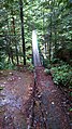 Footbridge on trail
 -
 Giant bigleaf maple covered in moss
 -
 Moss-covered alders rise from a floor of sword fern
 -
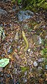 Banana slug along the trail on wet day
 -
 Waterfall on the creek in the park


See also
References
External links
- BC Parks. Fossli Provincial Park
49°15′00″N 124°57′00″W / 49.25000°N 124.95000°W / 49.25000; -124.95000
- v
- t
- e


