East Berbice-Corentyne
Region of Guyana
Administrative Region in New Amsterdam, Guyana
East Berbice-Corentyne Region 6 | |
|---|---|
Administrative Region | |
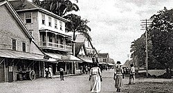 Strand, New Amsterdam (before 1900) | |
 Flag | |
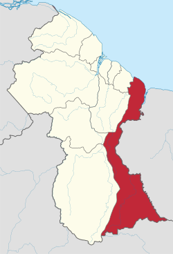 Map of Guyana showing East Berbice-Corentyne region | |
| Country | Guyana |
| Regional Capital | New Amsterdam |
| Area | |
| • Total | 36,234 km2 (13,990 sq mi) |
| Population (2012 census) | |
| • Total | 109,431 |
| • Density | 3.0/km2 (7.8/sq mi) |
| [1] | |
East Berbice-Corentyne (Region 6) is one of ten regions in Guyana covering the whole of the east of the country. It borders the Atlantic Ocean to the north, the Nickerie District and Sipaliwini District of Suriname to the east, Brazil to the south and the regions of Mahaica-Berbice, Upper Demerara-Berbice, Potaro-Siparuni and Upper Takutu-Upper Essequibo to the west.
Towns in the region include New Amsterdam, Corriverton and Rose Hall.
The Corentyne River forms the whole of the eastern border with Suriname, though the southernmost section is claimed by Suriname and is known as the Tigri Area.
Population
The Government of Guyana has administered three official censuses since the 1980 administrative reforms, in 1980, 1991 and 2002.[2] In 2012, the population of East Berbice-Corentyne was recorded at 109,431 people.[3] Official census records for the population of East Berbice-Corentyne are as follows:
- 2012 : 109,431
- 2002 : 123,695
- 1991 : 142,541
- 1980 : 152,386
Communities
(including name variants):[4]
- Adventure
- Albion
- Alness (Alnes)
- Ankerville - Port Mourant
- Baracara (Barakara Mission/Wel te Vreeden)
- Belvedere
- Bloomfield
- Bound Yard - Port Mourant
- Brighton
- Bush Lot (Bush Lot Village)
- Canefield
- Chesney
- Clifton Settlement - Port Mourant
- Corriverton
- Crabwood Creek
- Cumberland ( birthplace of Hetmyer}.
- Epira (Epira Mission, Espera)
- Friendship (Friendship Village, Corentyne)
- Free Yard - Port Mourant
- Fyrish (Fyrish Village)
- Gangaram
- Haswell - Port Mourant
- Johns Settlement - Port Mourant
- Kasuela )Cashew Island)
- Kumaka
- Lancaster (Lancaster Village)
- Leeds
- Letter Kenny
- Lesbeholden
- Limlair
- Liverpool
- Manchester
- Mibikuri
- Miss Phoebe North And South- Port Mourant
- Moleson Creek
- New Amsterdam
- New Hampshire
- Number 43 (Joppa)
- Number 46
- Number 48 (Floyd Ward)
- Number 55
- Number 59
- Number 60
- Number 61
- Number 62
- Number 63 (Benab)
- Number 64 (Babylon)
- Number 67
- Number 68 (Carnarvon)
- Number 69 (Friendship)
- Number 70 (Massiah)
- Nurney
- Orealla (Oreala, Orealla Mission)
- Port Mourant (Port Mourant Village)
- Portuguese Quarters - Port Mourant
- Reliance
- Rising (Rising Sun, Number 47)
- Rose Hall
- Skeldon (Skeldon Place)
- Smythfield
- Springlands (Springlands Place, Eliza and Mary)
- Stanleytown
- Tain Settlement - Port Mourant
- Tain Resource - Port Mourant
- Train Line Dam - Port Mourant
- Ulverston
- Whim
- Williamsburg
- Yakusari
See also
 Geography portal

References
- ^ Macmillan Publishers (2009). "Administrative Regions - 5 and 6". Macmillan Junior Atlas: Guyana. Oxford: Macmillan Caribbean. p. 35. ISBN 9780333934173.
- ^ Beaie, Sonkarley Tiatun (19 September 2007). "Chapter 3: National Redistribution and Internal Migration" (PDF). 2002 Population and Housing Census - Guyana National Report. Bureau of Statistics. p. 51. Archived from the original (PDF) on 17 February 2012. Retrieved 29 August 2012.
- ^ Beaie, Sonkarley Tiatun (19 September 2007). "National Population Trends: Size, Growth and Distribution". 2002 Population and Housing Census - Guyana National Report. Bureau of Statistics. p. 25. Archived from the original (PDF Download) on 9 September 2012. Retrieved 29 August 2012.
- ^ "2012 Population by Village". Statistics Guyana. Retrieved 8 December 2021.
- v
- t
- e

4°06′29″N 58°11′00″W / 4.107943°N 58.18337°W / 4.107943; -58.18337


