Croixanvec
Commune in Brittany, France
Part of Saint-Gérand-Croixanvec in Brittany, France
Croixanvec Kroeshañveg | |
|---|---|
Part of Saint-Gérand-Croixanvec | |
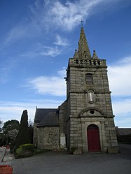 The Saint-Samson-et-Saint-Maurice church in Croixanvec | |
Location of Croixanvec  | |
48°08′25″N 2°52′05″W / 48.1403°N 2.8681°W / 48.1403; -2.8681 | |
| Country | France |
| Region | Brittany |
| Department | Morbihan |
| Arrondissement | Pontivy |
| Canton | Pontivy |
| Commune | Saint-Gérand-Croixanvec |
| Area 1 | 6.09 km2 (2.35 sq mi) |
| Population (2019)[1] | 173 |
| • Density | 28/km2 (74/sq mi) |
| Time zone | UTC+01:00 (CET) |
| • Summer (DST) | UTC+02:00 (CEST) |
| Postal code | 56920 |
| Elevation | 108–162 m (354–531 ft) |
| 1 French Land Register data, which excludes lakes, ponds, glaciers > 1 km2 (0.386 sq mi or 247 acres) and river estuaries. | |
Croixanvec (French pronunciation: [kʁwasɑ̃vɛk]; Breton: Kroeshañveg) is a former commune in the Morbihan department of Brittany in north-western France.[2] On 1 January 2022, it was merged into the new commune Saint-Gérand-Croixanvec.[3]
Demographics
Inhabitants of Croixanvec are called in French Croixanvequois.
See also
References
External links
Wikimedia Commons has media related to Croixanvec.
- Base Mérimée: Search for heritage in the commune, Ministère français de la Culture. (in French)
| Authority control databases: National |
|
|---|
- v
- t
- e


