Cricqueville-en-Bessin
You can help expand this article with text translated from the corresponding article in French. (December 2008) Click [show] for important translation instructions.
- View a machine-translated version of the French article.
- Machine translation, like DeepL or Google Translate, is a useful starting point for translations, but translators must revise errors as necessary and confirm that the translation is accurate, rather than simply copy-pasting machine-translated text into the English Wikipedia.
- Do not translate text that appears unreliable or low-quality. If possible, verify the text with references provided in the foreign-language article.
- You must provide copyright attribution in the edit summary accompanying your translation by providing an interlanguage link to the source of your translation. A model attribution edit summary is
Content in this edit is translated from the existing French Wikipedia article at [[:fr:Cricqueville-en-Bessin]]; see its history for attribution. - You may also add the template
{{Translated|fr|Cricqueville-en-Bessin}}to the talk page. - For more guidance, see Wikipedia:Translation.
Commune in Normandy, France
Cricqueville-en-Bessin | ||
|---|---|---|
Commune | ||
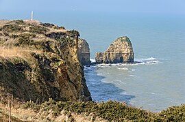 La Pointe du Hoc | ||
Location of Cricqueville-en-Bessin  | ||
(2022–2026) Pascale Vibet[1] | | |
| Area 1 | 8.55 km2 (3.30 sq mi) | |
| Population (2021)[2] | 170 | |
| • Density | 20/km2 (51/sq mi) | |
| Time zone | UTC+01:00 (CET) | |
| • Summer (DST) | UTC+02:00 (CEST) | |
| INSEE/Postal code | 14204 /14450 | |
| Elevation | 0–39 m (0–128 ft) (avg. 50 m or 160 ft) | |
| 1 French Land Register data, which excludes lakes, ponds, glaciers > 1 km2 (0.386 sq mi or 247 acres) and river estuaries. | ||
Cricqueville-en-Bessin (French pronunciation: [kʁikvil ɑ̃ bɛsɛ̃] ⓘ, literally Cricqueville in Bessin) is a commune in the Calvados department in the Normandy region in northwestern France.
The municipality takes its name from its deep-water creek that forms a natural harbor, from Crycavilla.
History
World War II
Just outside Cricqueville, the United States Army Air Forces established an airfield shortly after D-Day on 9 June 1944, just three days after the Allied landings in France. The airfield was one of the first established in the liberated area of Normandy. Known as Advanced Landing Ground "A-2" (Cricqueville), it was used from early June though September 1944. After the Americans moved east into Central France, the airfield was dismantled and the land returned to agricultural use.[3][4]
Population
| Year | Pop. | ±% |
|---|---|---|
| 1962 | 197 | — |
| 1968 | 200 | +1.5% |
| 1975 | 190 | −5.0% |
| 1982 | 157 | −17.4% |
| 1990 | 171 | +8.9% |
| 1999 | 182 | +6.4% |
| 2008 | 186 | +2.2% |
See also
- Communes of the Calvados department
- Pointe du Hoc, a point of attack by the United States Army during the Battle of Normandy
References
- ^ "Répertoire national des élus: les maires" (in French). data.gouv.fr, Plateforme ouverte des données publiques françaises. 6 June 2023.
- ^ "Populations légales 2021". The National Institute of Statistics and Economic Studies. 28 December 2023.
- ^ AAF Airfields in France, Belgium, Netherlands, Luxembourg Archived January 6, 2009, at the Wayback Machine
- ^ Air Force History Index
Wikimedia Commons has media related to Cricqueville-en-Bessin.
- v
- t
- e
 Communes of the Calvados department
- Ablon
- Agy
- Amayé-sur-Orne
- Amayé-sur-Seulles
- Amfreville
- Angerville
- Anisy
- Annebault
- Arganchy
- Argences
- Arromanches-les-Bains
- Asnelles
- Asnières-en-Bessin
- Auberville
- Aubigny
- Audrieu
- Aure sur Mer
- Aurseulles
- Authie
- Les Authieux-sur-Calonne
- Auvillars
- Avenay
- Balleroy-sur-Drôme
- Banneville-la-Campagne
- Banville
- Barbery
- Barbeville
- Barneville-la-Bertran
- Baron-sur-Odon
- Barou-en-Auge
- Basly
- Basseneville
- Bavent
- Bayeuxsubpr
- Bazenville
- La Bazoque
- Beaufour-Druval
- Beaumais
- Beaumesnil
- Beaumont-en-Auge
- Bellengreville
- Belle Vie en Auge
- Benerville-sur-Mer
- Bénouville
- Bény-sur-Mer
- Bernesq
- Bernières-d'Ailly
- Bernières-sur-Mer
- Beuvillers
- Beuvron-en-Auge
- Biéville-Beuville
- Blainville-sur-Orne
- Blangy-le-Château
- Blay
- Blonville-sur-Mer
- Le Bô
- La Boissière
- Bonnebosq
- Bonnemaison
- Bonneville-la-Louvet
- Bonneville-sur-Touques
- Bonnœil
- Bons-Tassilly
- Bougy
- Boulon
- Bourgeauville
- Bourguébus
- Branville
- Brémoy
- Bretteville-le-Rabet
- Bretteville-sur-Laize
- Bretteville-sur-Odon
- Le Breuil-en-Auge
- Le Breuil-en-Bessin
- Le Brévedent
- Bréville-les-Monts
- Bricqueville
- Brucourt
- Bucéels
- Le Bû-sur-Rouvres
- Cabourg
- Caenpref
- Cagny
- Cahagnes
- Cahagnolles
- La Caine
- Cairon
- La Cambe
- Cambes-en-Plaine
- Cambremer
- Campagnolles
- Campigny
- Canapville
- Canchy
- Canteloup
- Carcagny
- Cardonville
- Carpiquet
- Cartigny-l'Épinay
- Le Castelet
- Castillon
- Castillon-en-Auge
- Castine-en-Plaine
- Caumont-sur-Aure
- Cauvicourt
- Cauville
- Cernay
- Cesny-aux-Vignes
- Cesny-les-Sources
- Chouain
- Cintheaux
- Clarbec
- Clécy
- Cléville
- Colleville-Montgomery
- Colleville-sur-Mer
- Colombelles
- Colombières
- Colombiers-sur-Seulles
- Colomby-Anguerny
- Combray
- Commes
- Condé-en-Normandie
- Condé-sur-Ifs
- Condé-sur-Seulles
- Coquainvilliers
- Cordebugle
- Cordey
- Cormelles-le-Royal
- Cormolain
- Cossesseville
- Cottun
- Courcy
- Courseulles-sur-Mer
- Courtonne-la-Meurdrac
- Courtonne-les-Deux-Églises
- Courvaudon
- Crépon
- Cresserons
- Cresseveuille
- Creully sur Seulles
- Cricquebœuf
- Cricqueville-en-Auge
- Cricqueville-en-Bessin
- Cristot
- Crocy
- Croisilles
- Crouay
- Culey-le-Patry
- Cussy
- Cuverville
- Damblainville
- Danestal
- Deauville
- Démouville
- Le Détroit
- Deux-Jumeaux
- Dialan sur Chaîne
- Dives-sur-Mer
- Donnay
- Douville-en-Auge
- Douvres-la-Délivrande
- Dozulé
- Drubec
- Ducy-Sainte-Marguerite
- Ellon
- Émiéville
- Englesqueville-en-Auge
- Englesqueville-la-Percée
- Épaney
- Épinay-sur-Odon
- Épron
- Équemauville
- Eraines
- Ernes
- Escoville
- Espins
- Esquay-Notre-Dame
- Esquay-sur-Seulles
- Esson
- Estrées-la-Campagne
- Éterville
- Étréham
- Évrecy
- Falaise
- Fauguernon
- Le Faulq
- Feuguerolles-Bully
- Fierville-les-Parcs
- Firfol
- Fleury-sur-Orne
- La Folie
- La Folletière-Abenon
- Fontaine-Étoupefour
- Fontaine-Henry
- Fontaine-le-Pin
- Fontenay-le-Marmion
- Fontenay-le-Pesnel
- Formentin
- Formigny La Bataille
- Foulognes
- Fourches
- Fourneaux-le-Val
- Le Fournet
- Fourneville
- Frénouville
- Le Fresne-Camilly
- Fresné-la-Mère
- Fresney-le-Puceux
- Fresney-le-Vieux
- Fumichon
- Gavrus
- Géfosse-Fontenay
- Genneville
- Gerrots
- Giberville
- Glanville
- Glos
- Gonneville-en-Auge
- Gonneville-sur-Honfleur
- Gonneville-sur-Mer
- Goustranville
- Gouvix
- Grainville-Langannerie
- Grainville-sur-Odon
- Grandcamp-Maisy
- Grangues
- Graye-sur-Mer
- Grentheville
- Grimbosq
- Guéron
- Hermanville-sur-Mer
- Hermival-les-Vaux
- Hérouville-Saint-Clair
- Hérouvillette
- Heuland
- La Hoguette
- Honfleur
- L'Hôtellerie
- Hotot-en-Auge
- Hottot-les-Bagues
- La Houblonnière
- Houlgate
- Ifs
- Isigny-sur-Mer
- Les Isles-Bardel
- Janville
- Jort
- Juaye-Mondaye
- Juvigny-sur-Seulles
- Laize-Clinchamps
- Landelles-et-Coupigny
- Landes-sur-Ajon
- Langrune-sur-Mer
- Léaupartie
- Leffard
- Lessard-et-le-Chêne
- Lingèvres
- Lion-sur-Mer
- Lisieuxsubpr
- Lison
- Lisores
- Litteau
- Livarot-Pays-d'Auge
- Les Loges
- Les Loges-Saulces
- Longues-sur-Mer
- Longueville
- Longvillers
- Loucelles
- Louvagny
- Louvigny
- Luc-sur-Mer
- Magny-en-Bessin
- Maisoncelles-Pelvey
- Maisoncelles-sur-Ajon
- Maisons
- Maizet
- Maizières
- Malherbe-sur-Ajon
- Maltot
- Mandeville-en-Bessin
- Manerbe
- Manneville-la-Pipard
- Le Manoir
- Manvieux
- Le Marais-la-Chapelle
- Marolles
- Martainville
- Martigny-sur-l'Ante
- Mathieu
- May-sur-Orne
- Merville-Franceville-Plage
- Méry-Bissières-en-Auge
- Meslay
- Le Mesnil-au-Grain
- Le Mesnil-Eudes
- Le Mesnil-Guillaume
- Le Mesnil-Robert
- Le Mesnil-Simon
- Le Mesnil-sur-Blangy
- Le Mesnil-Villement
- Meuvaines
- Mézidon Vallée d'Auge
- Le Molay-Littry
- Les Monceaux
- Monceaux-en-Bessin
- Mondeville
- Mondrainville
- Monfréville
- Montfiquet
- Montigny
- Montillières-sur-Orne
- Montreuil-en-Auge
- Monts-en-Bessin
- Les Monts d'Aunay
- Morteaux-Coulibœuf
- Mosles
- Mouen
- Moulines
- Moulins en Bessin
- Moult-Chicheboville
- Les Moutiers-en-Auge
- Les Moutiers-en-Cinglais
- Moyaux
- Mutrécy
- Nonant
- Norolles
- Noron-l'Abbaye
- Noron-la-Poterie
- Norrey-en-Auge
- Notre-Dame-de-Livaye
- Notre-Dame-d'Estrées-Corbon
- Noues de Sienne
- Olendon
- Orbec
- Osmanville
- Ouézy
- Ouffières
- Ouilly-du-Houley
- Ouilly-le-Tesson
- Ouilly-le-Vicomte
- Ouistreham
- Parfouru-sur-Odon
- Pennedepie
- Périers-en-Auge
- Périers-sur-le-Dan
- Périgny
- Perrières
- Pertheville-Ners
- Petiville
- Pierrefitte-en-Auge
- Pierrefitte-en-Cinglais
- Pierrepont
- Le Pin
- Planquery
- Plumetot
- La Pommeraye
- Pont-Bellanger
- Pont-d'Ouilly
- Pontécoulant
- Pont-Farcy
- Pont-l'Évêque
- Port-en-Bessin-Huppain
- Ponts sur Seulles
- Potigny
- Préaux-Bocage
- Le Pré-d'Auge
- Prêtreville
- Putot-en-Auge
- Quetteville
- Ranchy
- Ranville
- Rapilly
- Repentigny
- Reux
- Reviers
- La Rivière-Saint-Sauveur
- La Roque-Baignard
- Rocques
- Rosel
- Rots
- Rouvres
- Rubercy
- Rumesnil
- Ryes
- Saint-André-d'Hébertot
- Saint-André-sur-Orne
- Saint-Arnoult
- Saint-Aubin-d'Arquenay
- Saint-Aubin-des-Bois
- Saint-Aubin-sur-Mer
- Saint-Benoît-d'Hébertot
- Saint-Côme-de-Fresné
- Saint-Contest
- Saint-Denis-de-Mailloc
- Saint-Denis-de-Méré
- Saint-Désir
- Sainte-Croix-sur-Mer
- Sainte-Honorine-de-Ducy
- Sainte-Honorine-du-Fay
- Sainte-Marguerite-d'Elle
- Sainte-Marie-Outre-l'Eau
- Saint-Étienne-la-Thillaye
- Saint-Gatien-des-Bois
- Saint-Germain-de-Livet
- Saint-Germain-du-Pert
- Saint-Germain-la-Blanche-Herbe
- Saint-Germain-Langot
- Saint-Germain-le-Vasson
- Saint-Hymer
- Saint-Jean-de-Livet
- Saint-Jouin
- Saint-Julien-sur-Calonne
- Saint-Lambert
- Saint-Laurent-de-Condel
- Saint-Laurent-sur-Mer
- Saint-Léger-Dubosq
- Saint-Louet-sur-Seulles
- Saint-Loup-Hors
- Saint-Manvieu-Norrey
- Saint-Marcouf
- Saint-Martin-aux-Chartrains
- Saint-Martin-de-Bienfaite-la-Cressonnière
- Saint-Martin-de-Blagny
- Saint-Martin-de-Fontenay
- Saint-Martin-de-la-Lieue
- Saint-Martin-de-Mailloc
- Saint-Martin-de-Mieux
- Saint-Martin-des-Entrées
- Saint-Omer
- Saint-Ouen-du-Mesnil-Oger
- Saint-Ouen-le-Pin
- Saint-Pair
- Saint-Paul-du-Vernay
- Saint-Philbert-des-Champs
- Saint-Pierre-Azif
- Saint-Pierre-Canivet
- Saint-Pierre-des-Ifs
- Saint-Pierre-du-Bû
- Saint-Pierre-du-Fresne
- Saint-Pierre-du-Jonquet
- Saint-Pierre-du-Mont
- Saint-Pierre-en-Auge
- Saint-Rémy
- Saint-Samson
- Saint-Sylvain
- Saint-Vaast-en-Auge
- Saint-Vaast-sur-Seulles
- Saint-Vigor-le-Grand
- Sallen
- Sallenelles
- Sannerville
- Saon
- Saonnet
- Sassy
- Seulline
- Soignolles
- Soliers
- Sommervieu
- Soulangy
- Souleuvre en Bocage
- Soumont-Saint-Quentin
- Subles
- Sully
- Surrain
- Surville
- Terres de Druance
- Tessel
- Thaon
- Le Theil-en-Auge
- Thue et Mue
- Thury-Harcourt-le-Hom
- Tilly-sur-Seulles
- Le Torquesne
- Touffréville
- Touques
- Tour-en-Bessin
- Tourgéville
- Tournières
- Tourville-en-Auge
- Tourville-sur-Odon
- Tracy-Bocage
- Tracy-sur-Mer
- Tréprel
- Trévières
- Troarn
- Le Tronquay
- Trouville-sur-Mer
- Trungy
- Urville
- Ussy
- Vacognes-Neuilly
- Valambray
- Valdallière
- Val d'Arry
- Val de Drôme
- Val-de-Vie
- Valorbiquet
- Valsemé
- Varaville
- Vaucelles
- Vauville
- Vaux-sur-Aure
- Vaux-sur-Seulles
- Vendes
- Vendeuvre
- Versainville
- Verson
- Ver-sur-Mer
- La Vespière-Friardel
- Le Vey
- Vicques
- Victot-Pontfol
- Vienne-en-Bessin
- Vierville-sur-Mer
- Vieux
- Vieux-Bourg
- Vignats
- Villers-Bocage
- Villers-Canivet
- Villers-sur-Mer
- Villerville
- La Villette
- Villons-les-Buissons
- Villy-Bocage
- Villy-lez-Falaise
- Vimont
- Vire Normandiesubpr
- pref: prefecture
- subpr: subprefecture
| Authority control databases: National |
|
|---|
 | This Calvados geographical article is a stub. You can help Wikipedia by expanding it. |
- v
- t
- e


