Cartography of Sri Lanka
The cartography of Sri Lanka is the history of the surveying and creation of maps of Sri Lanka. A list of maps of Sri Lanka in chronological order is shown below.
Maps
| Date | Carto- grapher | Description | Image |
|---|---|---|---|
| 1st century CE | 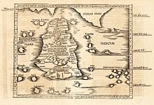 | ||
| 1482 |  | ||
| 1595 | Petrus Plancius | Left–right is north–south. |  |
| 1681 | Robert Knox |  | |
| 17th century; after 1681 | Nicolaes Visscher II | 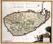 | |
| 1686 | Alain Manesson Mallet |  | |
| 17th century | Robert Morden |  | |
| 1789 |  | ||
| late-19th century |  | ||
| c. 1914 |  |
Small-scale maps
| Date | Title | Carto- grapher | Description | Image |
|---|---|---|---|---|
| 1815 | Sketch map of Kandy and environ in 1815 |  | ||
| 1914 | Map of Kandy and environs |  |
References
- v
- t
- e
Cartography topics
- The World
- Africa
- Asia
- Europe
- China
- France
- India
- Jamaica
- New Zealand
- Palestine
- Switzerland
- Ukraine
- United States
| Ancient age |
|
|---|---|
| Middle age |
|
| Early Modern age |
|
| Contemporary age | |
| See also |


