Cairo Metro Line 2
4 ft 8+1⁄2 in)Electrification Third rail, 750 V DC[5] Operating speed 100 km/h (62 mph) Line 1 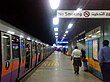
Line 2 Line 3
Cairo Metro Line 2 is the second line of the Cairo Metro in Cairo, Egypt.
History
Cairo's metro network was greatly expanded in the mid-1990s with the building of Line 2 (red), from Shubra Al Khaimah to Cairo University, with an extension to Giza.
It is the first line in history to have a tunnel going under the Nile.[6][7] The tunnel under the Nile is 8.35 m (27 ft 5 in) in internal diameter and was constructed using two Herenknecht bentonite slurry shield TBMs, which are 9.43 m (30 ft 11 in) in diameter.[6] Extending 21.5 kilometres (13 mi) with 20 stations, it is sometimes called the "Japanese-Built Line".[citation needed] It is mostly in bored tunnel, with two exceptions: a short section at the northern end approaching Shubra El-Kheima which is elevated, and a section just south of this by cut-and-cover. The main difference between Lines 1 and 2 is that Line 1 uses an overhead line while Line 2 uses the third-rail system.[citation needed] The construction of the line was finished in October 2000 and was later extended to El Mounib.[6] The communication for line 2 was provided by Alcatel in 2005.[8]
Total project cost was 761 million euros.
After the 2011 Egyptian revolution, the station "Mubarak" has been renamed and is now called "Al-Shohadaa" (Arabic for "martyrs").
- October 1996 Shobra - Mubarak (now:"Al-Shohadaa"), 8 kilometres (5 mi)[9]
- Sept 1998: Mubarak (now:"Al-Shohadaa") - Sadat, 3 kilometres (2 mi)[9]
- April 19, 1999: Sadat - Cairo University, 5.5 kilometres (3 mi) (including crossing of the Nile)[9]
- October 8, 2000: Cairo University - Giza Suburban 2.7 kilometres (2 mi)[9]
- January 17, 2005: Omm el Misryeen - Monib 2.5 kilometres (2 mi)[9]
Connections
To other Metro lines
Line 2 connects to Line 1 at Al-Shohadaa and Sadat stations and with Line 3 at Cairo University and Attaba stations.
To other forms of transit
Because the line often run parallelly with the railway, a few stations are near to the train stations, including:
- Shohadaa station is immediately next to Ramses Station, providing access to Egyptian National Railways long-haul and short-haul domestic passenger service.
- Shubra El-Kheima station is next to the train station of the same name.
- Giza train station is located next to Um Al Masriyeen station.
Cairo Transport Authority buses and private microbus services are also nearby.
Access to Cairo International Airport is expected via transfer to Line 3 upon completion of Phase 4 in early 2020.[10]
See also
References
- ^ "TWINNING PROJECT FICHE - Assistance to the Egyptian Metro Company (ECM) in Reforming Railway Safety Regulations, Procedures and Practices" (PDF). Retrieved 4 August 2014.
- ^ "About Company". Cairo Metro. Archived from the original on 17 August 2014. Retrieved 31 July 2014.
- ^ "The Development of Passenger Traffic for The Two metro lines since inauguration (the first 87/88, the second 96/97) Until 2009/2010" (in Arabic). Cairo Metro. Archived from the original on 2012-03-23. Retrieved 2014-08-04.
- ^ a b "Line 2". National Authority for Tunnels. Archived from the original on 16 September 2019. Retrieved 3 August 2014.
- ^ Banerjee, M.K.; El Hoda, N. (October 1998). "Review of the automatic train control system for Cairo Metro line 2". Power Engineering Journal. 12 (5). IET: 217–228. doi:10.1049/pe:19980506. ISSN 0950-3366.
- ^ a b c "Greater Cairo Metro Network". Egyptian Tunneling Society. 2007-04-15. Retrieved 2008-10-20.
- ^ "Cairo's metro goes under Nile". World: Middle East. BBC News. 1999-04-19. Retrieved 2008-10-28.
- ^ "Alcatel extends the communications infrastructure of Cairo's metro line 2". Paris: Alcatel Lucent. 2005-04-26. Archived from the original on 2005-10-23. Retrieved 2008-10-27.
- ^ a b c d e "CAIRO". urbanrail.net. Retrieved 4 August 2014.
- ^ "النقل تعلن موعد انتهاء محطات المرحلة الرابعة بالخط الثالث للمترو". Masrawy. 24 July 2019. Retrieved 7 July 2023.
- v
- t
- e

- New Marg
- El-Marg
- Ezbet El-Nakhl
- Ain Shams
- El-Matareyya
- Helmeyet El-Zaitoun
- Hadayeq El-Zaitoun
- Saray El-Qobba
- Hammamat El-Qobba
- Kobri El-Qobba
- Manshiet El-Sadr
- El-Demerdash
- Ghamra
- Al-Shohadaa
- Orabi
- Nasser
- Sadat
- Saad Zaghloul
- Al-Sayeda Zeinab
- El-Malek El-Saleh
- Mar Girgis
- El-Zahraa
- Dar El-Salam
- Hadayeq El-Maadi
- Maadi
- Sakanat El-Maadi
- Tora El-Balad
- Kozzika
- Tura El-Esmant
- Elmasraa
- Hadayek Helwan
- Wadi Hof
- Helwan University
- Ain Helwan
- Helwan

- Shubra Al Khaimah
- Koliet El-Zeraa
- Mezallat
- Khalafawy
- St. Teresa
- Rod El-Farag
- Masarra
- Al-Shohadaa
- Attaba
- Mohamed Naguib
- Sadat
- Opera
- Dokki
- El Bohoth
- Cairo University
- Faisal
- Giza
- Omm El-Masryeen
- Sakiat Mekky
- El Monib
- Adly Mansour
- Haykestep
- Omar Ibn El Khattab
- Qubaa
- Hesham Barakat
- El Nozha
- El Shams Club
- Alf Masken
- Heliopolis
- Haroun
- Al-Ahram
- Koleyet El-Banat
- Stadium
- Abbassiya
- Fair Zone
- Abdou Pasha
- El-Geish
- Bab El Shaariya
- Attaba
- Nasser
- Maspero
- Safaa Hijazy
- Kit-Kat
- Sudan
- Imbaba
- El-Bohy
- El-Qawmia
- Ring Road
- Rod El Farag Corridor
- Tawfikia
- Wadi El Nile
- Gamet El Dowal
- Boulak El Dakrour
- Cairo University
| Authority control databases: Geographic |
|
|---|


