Céu Azul
Municipality in Southern, Brazil
Céu Azul-Paraná Céu Azul-Paraná | |
|---|---|
Municipality | |
 Flag  Seal | |
| Nickname: Céu Azul-Paraná | |
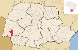 Location of Céu Azul in Paraná | |
| 25°8′49″S 53°50′56″W / 25.14694°S 53.84889°W / -25.14694; -53.84889 | |
| Country |  Brazil Brazil |
| Region | Southern |
| State | Paraná |
| Mesoregion | Oeste Paranaense |
| Government | |
| • Mayor | Jaime Basso |
| Area | |
| • Total | 455.4 sq mi (1,179.5 km2) |
| Population (2020 [1]) | |
| • Total | 11,819 |
| • Density | 24.2/sq mi (9.35/km2) |
| Time zone | UTC−3 (BRT) |
Céu Azul is a municipality in the state of Paraná in the Southern Region of Brazil.[2]
Céu Azul covers 1,179.5 square kilometres (455.4 sq mi), has a population of 11,819, and population density of 9.35 resident per square kilometer. 852 square kilometres (329 sq mi) of the city is preserved as Atlantic Forest and is part of Iguaçu National Park.[2][3]
The western region of Paraná was the target of logging companies in the 1950s. The company Pinho e Terras Ltda. installed a colony in the area in 1952 and brought workers, mainly from the state of Rio Grande do Sul. The first residents were primarily of German and Italian origin.[3]
See also
References
- ^ IBGE 2020
- ^ a b "Paraná: Céu Azul" (in Portuguese). Instituto Brasileiro de Geografia e Estatística. 2016. Retrieved 2016-07-25.
- ^ a b "História do município" (in Portuguese). Retrieved 2016-07-25.
- v
- t
- e

Capital: Curitiba
Centro Ocidental Paranaense | |||||
|---|---|---|---|---|---|
| |||||

Centro Oriental Paranaense | |||||||
|---|---|---|---|---|---|---|---|
| |||||||
Centro-Sul Paranaense | |||||||
|---|---|---|---|---|---|---|---|
| |||||||
Metropolitana de Curitiba | |||||||||||
|---|---|---|---|---|---|---|---|---|---|---|---|
| |||||||||||
Norte Central Paranaense | |||||||||||||||||
|---|---|---|---|---|---|---|---|---|---|---|---|---|---|---|---|---|---|
| |||||||||||||||||
Norte Pioneiro Paranaense | |||||||||||
|---|---|---|---|---|---|---|---|---|---|---|---|
| |||||||||||
Oeste Paranaense | |||||||
|---|---|---|---|---|---|---|---|
| |||||||
Sudeste Paranaense | |||||||||
|---|---|---|---|---|---|---|---|---|---|
| |||||||||
Sudoeste Paranaense | |||||||
|---|---|---|---|---|---|---|---|
| |||||||
25°08′49″S 53°50′56″W / 25.1469°S 53.8489°W / -25.1469; -53.8489
 | This Paraná, Brazil location article is a stub. You can help Wikipedia by expanding it. |
- v
- t
- e


