Bonnie Doon, Victoria
Town in Victoria, Australia
37°01′S 145°51′E / 37.017°S 145.850°E / -37.017; 145.850- 168 km (104 mi) NE of Melbourne
- 22 km (14 mi) NE of Alexandra
- 21.1 km (13 mi) W of Mansfield
Bonnie Doon is a town in Victoria, Australia. It is located on the Maroondah Highway, in the Shire of Mansfield. Bonnie Doon is 168 kilometres north-east from Melbourne. At the 2021 census, Bonnie Doon township had a population of 666.[1]
History
The township was established subsequent to gold discoveries in the area. It was originally named Doon after the town of that name in Ireland. The Post Office opened on 1 October 1866 and was renamed Bonnie Doon in 1891 coinciding with the arrival of the railway.[2]
Much of the original town of Bonnie Doon was flooded by the construction of Lake Eildon in the 1950s. The township was relocated; some buildings were picked up and moved, whilst others were able to remain in their original site, such as the churches.
Tourism

Lake Eildon makes Bonnie Doon a minor tourist town for water activities, and the surrounds of Bonnie Doon, which has a rail trail, are somewhat popular for weekend holidaymakers. This popularity was satirised in the Australian comedy, The Castle, with popular quotes such as "How's the serenity?" and its catch-phrase song "We're going to Bonnie Doon".

Lake
-
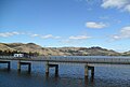 Lake Eildon and bridge, Bonnie Doon
 -
 Lake Eildon near Maroondah Hwy.


References
- ^ a b "2021 Census Bonnie Doon". Australian Bureau of Statistics. Retrieved 29 September 2023.
- ^ Phoenix Auctions History, Post Office List, retrieved 20 January 2021
External links
Wikimedia Commons has media related to Bonnie Doon, Victoria.
- Bonnie Doon Community
- Great Victorian Rail Trail
- Australian Places - Bonnie Doon
- Goulburn River High Country Rail Trail
- v
- t
- e
Localities in the Shire of Mansfield
- Barwite
- Bonnie Doon
- Goughs Bay
- Jamieson
- Maindample
- Mansfield
- Merrijig
- Merton^
- Mount Buller^
- Tolmie^

- Ancona
- Barjarg
- Boorolite
- Bridge Creek^
- Creek Junction^
- Delatite
- Enochs Point^
- Gaffneys Creek
- Howes Creek
- Howqua
- Howqua Hills
- Howqua Inlet
- Kanumbra^
- Kevington
- Knockwood
- Lake Eildon
- Macs Cove
- Matlock^
- Mirimbah^
- Mountain Bay
- Piries
- Reynard^
- Sawmill Settlement
- Woodfield
- Woods Point
^ - Territory divided with another LGA


