Boca Chica Key
Island in the lower Florida Keys
24°34′39″N 81°41′36″W / 24.5774°N 81.6933°W / 24.5774; -81.6933
 United States
Boca Chica Key is an island in the lower Florida Keys, about a mile (1.6 km) east of the island of Key West at its closest point. Its name is Spanish for "small mouth". It is mostly covered by salt marshes and mangrove trees, and is the home of the largest Naval Air Station (NAS Key West) in south Florida. U.S. 1, the Overseas Highway, crosses the key at approximately mile markers 6.5—8, east of Key West.,[1] near the NAS and Boca Chica Beach (aka Geiger Beach) on Boca Chica Road.[2][3]

Gallery
-
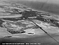 Boca Chica Key, April 1940
 -
 Boca Chica Key, April 1940


References
- v
- t
- e
Florida Keys
- Soldier
- Ragged
- Boca Chita
- Sands
- Elliott
- Adams
- Caesar's Rock
- Meig's
- Rubicon
- Reid
- Porgy
- Totten
- Old Rhodes
- Islandia
- Pigeon
- Money
- Little Duck
- Missouri
- Ohio
- Sunshine
- Bahia Honda
- Spanish Harbor
- Scout (West Summerland)
- No Name
- Big Pine
- Torch
- Ramrod
- Summerland
- Knockemdown
- Cudjoe
- Sugarloaf
- Park
- Lower Sugarloaf
- Saddlebunch
- Shark
- Geiger
- Big Coppitt
- East Rockland
- Rockland
- Boca Chica
- Raccoon
- Stock Island
- Key West
- Sigsbee
- Fleming
- Sunset
- Wisteria
- Florida Bay
- Dry Tortugas National Park
- Florida Keys National Marine Sanctuary
- National Key Deer Refuge
- John Pennekamp Coral Reef State Park
- Biscayne Bay
- Biscayne National Park
- Key West National Wildlife Refuge
- Great White Heron National Wildlife Refuge
- Crocodile Lake National Wildlife Refuge
- Florida Reef
 | This Monroe County, Florida location article is a stub. You can help Wikipedia by expanding it. |
- v
- t
- e


