Babang Township, Sichuan
Township in Sichuan, China
Babang 八邦乡 | |
|---|---|
Township | |
| Palpung | |
 View of traditional log homes along the Pal Chu (river) in Babang Township | |
31°38′36″N 98°47′49″E / 31.64333°N 98.79694°E / 31.64333; 98.79694 | |
| Country | China |
| Province | Sichuan |
| Prefecture | Garzê Tibetan Autonomous Prefecture |
| County | Dêgê County |
| Area | |
| • Total | 555.2 km2 (214.4 sq mi) |
| Elevation | 3,720 m (12,200 ft) |
| Population (2010)[1] | |
| • Total | 2,638 |
| Time zone | UTC+8 (CST) |
Babang (Tibetan: Palpung; Chinese: 八邦乡; pinyin: Bābāng Xiāng) is a rural Tibetan township in Dêgê County, Garzê Prefecture, Sichuan, China.[1] The township is primarily concentrated around the Pal Chu (Chinese: 白曲; pinyin: Bái Qū) river in the western reaches of the Chola Mountains on the east side of the Jinsha River.[2] The township contains significant remaining tracts of the Hengduan conifer forests.
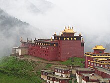
Babang is known for the 18th-century Palpung Monastery located on a ridge approximately 160 m (520 ft) above the centre of the township.
See also
References
- ^ a b c "BĀBĀNG XIĀNG". City Population. www.citypopulation.de. Retrieved 3 January 2022.
- ^ McCue, Gary (2010). Trekking Tibet: A Traveler's Guide. Seattle, WA: The Mountaineer's Books. ISBN 9781594852664.
- v
- t
- e


- Lucheng
- Batang Town
- Zhaggo
- Xindu
- Garba
- Garzê
- Hekou
- Rulong
- Jianshe
- Derge (Goinqên)
- Axu Town
- Litang Town
- Shambala
- Nyongxar
- Jinzhu
- Sêrkog
- Luqiao
- Lengqi
- Xinglong
- Moxi
- Lan'an
- Pengba
- Tianba
- Chuni
- Jiajun
- Dewei
- Xinxing
- Detuo
- Sangmai
- Bumser
- Dzagyel
- Junyung
- Jowo
- Kabshi
- Kyangma
- Pathul
- Kyewu
- Sershul Town
- Tseboum Soumdo
- Tsemkhog
- Wombo
- Sêrxü County
- Danba County
- Mount Gongga
- Dadu River


