Altmühl Valley Nature Park
48°49′04″N 11°13′37″E / 48.81782°N 11.22707°E / 48.81782; 11.22707Area 2,962 km2 (1,144 sq mi)[1] Designation NP-00016 Established 1969 
The Altmühl Valley Nature Park (German: Naturpark Altmühltal) is a nature park, 2,962 km²[1] in area, in the south German state of Bavaria. The area of the park is almost coextensive with that of the natural region major unit of the Southern Franconian Jura (Südliche Frankenalb). It lies immediately north of the city of Ingolstadt on the River Danube and is divided into a southern and northern Altmühl Valley.[2][3]
Description
The nature park was established on 25 July 1969[4] in Pappenheim by society formed for the purpose, the Naturpark Altmühltal (Südliche Frankenalb) ("Altmühl Valley Nature Park (Southern Franconian Jura)"). It is the fourth largest nature park in Germany after the Central/North Black Forest Nature Park, Bergstraße-Odenwald Nature Park and Southern Black Forest Nature Park.
-
 Arnsberger Leite
 -
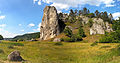 Burgstein
 -
 Zwölf Apostel
 -
 Weltenburger Enge
 -
 Danube at Weltenburger Enge
 -
 Villages and valleys
 -
 Arzberg
 -
 Sinter terraces
 -
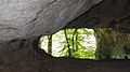 Cave-systems
 -
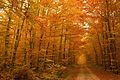 Autumn in Harburger Karab forest
 -
 Autumn at Galgenberg
 -
 Figurenfeld sculpture park
 -
 Nature park sign


See also
References
- ^ a b Area of the nature park:
– 2962 km²: Liste der Naturparke (Association of German Nature Parks), retrieved 20 August 2014, at naturparke.de
according to other sources:
– 2967 km²: Der Naturpark Altmühltal, retrieved 12 October 2016, at naturpark-altmuehltal.de (pdf; 67.16 KB) - ^ Map services of the Federal Agency for Nature Conservation
- Map Service Landschaften shows the boundaries of individual sub-regions and produces landscape fact files with areas (82xxx=Südliche Frankenalb) clickable (JavaScript required, very restricted browser compatibility)
- Map Service Schutzgebiete shows hill heights down to TK 25;
nature reserves, special areas of conservation, nature parks (with areas), major units and communal boundaries are displayable (flash player required)
- ^ Naturpark Altmühltal, retrieved 24 April 2014, at openstreetmap.org
- ^ Der Naturpark Altmühltal, retrieved 12 October 2016, at naturpark-altmuehltal.de (pdf; 67.16 KB)
Literature
- Das Tal der Uraltmühl, 144 Seiten, Tümmels, Nuremberg, ISBN 3-921590-98-1
- Das Urdonautal der Altmühl, 132 Seiten, Tümmels, Nuremberg, ISBN 3-921590-88-4
External links
Wikimedia Commons has media related to Altmühl Valley Nature Park.
Wikivoyage has a travel guide for Altmühl Valley Nature Park.
- Altmühl Valley Nature Park, at naturpark-altmuehltal.de
- v
- t
- e
Nature parks in Bavaria
- Altmühl Valley
- Augsburg-Western Woods
- Bavarian Rhön
- Bavarian Forest
- Bergstraße-Odenwald
- Fichtel Mountains
- Frankenhöhe
- Franconian Forest
- Franconian Switzerland-Veldenstein Forest
- Haßberge
- Hirschwald
- Nagelfluhkette
- Northern Upper Palatinate Forest
- Upper Bavarian Forest
- Upper Palatinate Forest
- Spessart
- Steigerwald
- Steinwald

Authority control databases | |
|---|---|
| International |
|
| National |
|


