|
|
| Localització |
|---|
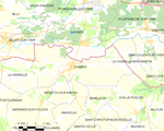  |  | | 47° 15′ 18″ N, 1° 39′ 12″ E / 47.255°N,1.6533°E / 47.255; 1.6533 |
|
|
|
| Estat | França |
| Entitat territorial administrativa | França Europea |
| Regió | Centre-Vall del Loira |
| Departament | Indre |
| Districte | Districte d'Issoudun |
| Cantó | Cantó de Saint-Christophe-en-Bazelle |
| |
| |
| Població humana |
|---|
| Població | 2.764 (2021) (67,05 hab./km²) |
|---|
| Geografia |
|---|
| Entitat estadística | àrea de concentració metropolitana de Romorantin-Lanthenay |
|---|
| Superfície | 41,22 km² |
|---|
| Banyat per | Riu Cher |
|---|
| Altitud | 72 m |
|---|
| Limita amb | Dun-le-Poëlier La Vernelle La Chapelle-Montmartin Gièvres Val-Fouzon Parpeçay Sembleçay Menetou-sur-Nahon Selles-sur-Cher |
|---|
| Identificador descriptiu |
|---|
| Codi postal | 36210 |
|---|
|
|
| Lloc web | chabris.fr |
|---|
 |


 Municipis de l'Indre


